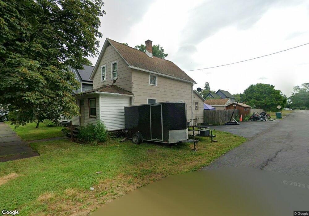
1 2nd Ave North Tonawanda, NY 14120
Estimated Value: $117,000 - $162,000
2
Beds
1
Bath
1,360
Sq Ft
$103/Sq Ft
Est. Value
About This Home
This home is located at 1 2nd Ave, North Tonawanda, NY 14120 and is currently estimated at $140,499, approximately $103 per square foot. 1 2nd Ave is a home located in Niagara County with nearby schools including North Tonawanda Intermediate School and St Matthew Lutheran School.
Ownership History
Date
Name
Owned For
Owner Type
Purchase Details
Closed on
Jan 9, 2006
Sold by
Citifinancial Mtg Co Inc
Bought by
Kanouff Mary
Current Estimated Value
Purchase Details
Closed on
Jun 25, 2004
Sold by
Citifinancial Mortgage Company
Bought by
Kanouff Mary
Purchase Details
Closed on
Feb 27, 2004
Sold by
Simon Dominick
Bought by
Citifinancial Mortgage Co
Purchase Details
Closed on
Jan 20, 2004
Sold by
Simon Dominick
Bought by
Citifinanacial Mortgage Co
Purchase Details
Closed on
May 9, 1997
Sold by
Tierney Martha
Bought by
Simon Dominick G and Simon Darlene M
Create a Home Valuation Report for This Property
The Home Valuation Report is an in-depth analysis detailing your home's value as well as a comparison with similar homes in the area
Home Values in the Area
Average Home Value in this Area
Purchase History
| Date | Buyer | Sale Price | Title Company |
|---|---|---|---|
| Kanouff Mary | -- | C Kenneth Foit | |
| Citifinancial Mtg Co Inc | -- | Steven Baum | |
| Kanouff Mary | $14,000 | Kenneth C Foit | |
| Citifinancial Mortgage Co | -- | Steven J Baum | |
| Citifinanacial Mortgage Co | $27,400 | Steven Baum | |
| Simon Dominick G | $48,000 | -- |
Source: Public Records
Tax History Compared to Growth
Tax History
| Year | Tax Paid | Tax Assessment Tax Assessment Total Assessment is a certain percentage of the fair market value that is determined by local assessors to be the total taxable value of land and additions on the property. | Land | Improvement |
|---|---|---|---|---|
| 2024 | $1,672 | $49,000 | $10,100 | $38,900 |
| 2023 | $1,672 | $49,000 | $10,100 | $38,900 |
| 2022 | $1,648 | $49,000 | $10,100 | $38,900 |
| 2021 | $1,636 | $49,000 | $10,100 | $38,900 |
| 2020 | $1,595 | $49,000 | $10,100 | $38,900 |
| 2019 | $1,495 | $46,000 | $10,100 | $35,900 |
| 2018 | $1,518 | $46,000 | $10,100 | $35,900 |
| 2017 | $1,495 | $46,000 | $10,100 | $35,900 |
| 2016 | $1,469 | $46,000 | $10,100 | $35,900 |
| 2015 | -- | $46,000 | $10,100 | $35,900 |
| 2014 | -- | $46,000 | $10,100 | $35,900 |
Source: Public Records
Map
Nearby Homes
- 51 Ritchie Lot #2 Ave
- 512 Oliver St
- 34 Center Ave
- 19 5th Ave
- 123 N Marion St
- 415 Oliver St
- 65 6th Ave
- 3941 Wheatfield St
- 3947 Wheatfield St
- 3911 Wheatfield St
- 699 Oliver St
- 114 Keil St
- 125 7th Ave
- 196 Robinson St
- 120 7th Ave
- 233 Lindsay Place
- 148 Schenck St
- 178 Schenck St
- 223 Schenck St
- 421 Stanley St