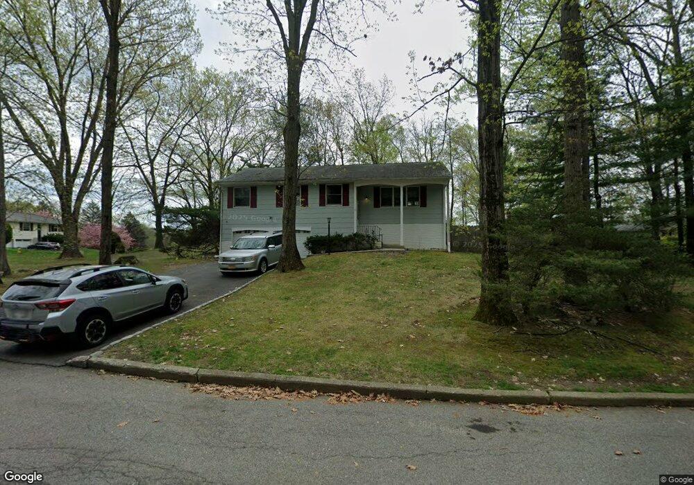
1 Aspen Ct Ossining, NY 10562
North Ossining NeighborhoodEstimated Value: $727,000 - $760,000
3
Beds
2
Baths
1,717
Sq Ft
$435/Sq Ft
Est. Value
About This Home
This home is located at 1 Aspen Ct, Ossining, NY 10562 and is currently estimated at $746,390, approximately $434 per square foot. 1 Aspen Ct is a home located in Westchester County with nearby schools including Park School, Claremont School, and Brookside Elementary School.
Ownership History
Date
Name
Owned For
Owner Type
Purchase Details
Closed on
Feb 2, 2021
Sold by
Goldman Andrew and Maltby Andrew
Bought by
Tisbury Llc
Current Estimated Value
Purchase Details
Closed on
May 4, 2000
Sold by
Goldman Marshall S and Maltby John
Bought by
Goldman Andrew and Maltby Andrew
Purchase Details
Closed on
Aug 2, 1999
Sold by
Millward David
Bought by
Goldman Marshall S and Maltby John
Create a Home Valuation Report for This Property
The Home Valuation Report is an in-depth analysis detailing your home's value as well as a comparison with similar homes in the area
Home Values in the Area
Average Home Value in this Area
Purchase History
| Date | Buyer | Sale Price | Title Company |
|---|---|---|---|
| Tisbury Llc | $51,562 | None Available | |
| Goldman Andrew | $298,800 | -- | |
| Goldman Marshall S | $300,000 | Commonwealth Land Title Ins |
Source: Public Records
Tax History Compared to Growth
Tax History
| Year | Tax Paid | Tax Assessment Tax Assessment Total Assessment is a certain percentage of the fair market value that is determined by local assessors to be the total taxable value of land and additions on the property. | Land | Improvement |
|---|---|---|---|---|
| 2024 | -- | $541,100 | $186,600 | $354,500 |
| 2023 | $8,779 | $502,000 | $186,600 | $315,400 |
| 2022 | $6,389 | $456,700 | $186,600 | $270,100 |
| 2021 | $6,389 | $411,500 | $186,600 | $224,900 |
| 2020 | $6,211 | $411,500 | $186,600 | $224,900 |
| 2019 | $7,831 | $392,900 | $207,300 | $185,600 |
| 2018 | $6,037 | $392,900 | $207,300 | $185,600 |
| 2017 | $2,818 | $389,100 | $207,300 | $181,800 |
| 2016 | $52,223 | $381,400 | $207,300 | $174,100 |
| 2015 | $6,279 | $24,040 | $6,300 | $17,740 |
| 2014 | $6,279 | $24,040 | $6,300 | $17,740 |
| 2013 | $6,279 | $24,040 | $6,300 | $17,740 |
Source: Public Records
Map
Nearby Homes
- 13 Reeback Dr
- 47 Stormytown Rd
- 11 Knollwood Dr
- 126 Whitetail Cir
- 113 Antler Ridge Unit 113
- 14 Steven Dr
- 2 Briarcliff Dr S Unit 3
- 70 Cedar Ln
- 283 Horse Shoe Cir
- 10 Nicole Cir Unit 12
- 15 Steven Dr Unit 4
- 7 Briarcliff Dr S Unit 13
- 8 Hudson Watch Dr
- 63 Cedar Ln
- 14 Pond View Ln
- 9 Gualtiere Ln
- 7 Hawkes Ave
- 9 High Ridge Rd
- 200 Route 9a
- 101 Eagle Bay Dr Unit 101