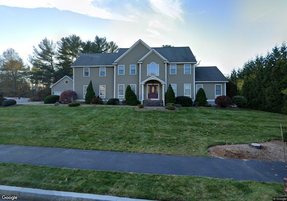
1 Berridge Way North Reading, MA 01864
Estimated Value: $1,241,716 - $1,540,000
4
Beds
4
Baths
4,000
Sq Ft
$355/Sq Ft
Est. Value
About This Home
This home is located at 1 Berridge Way, North Reading, MA 01864 and is currently estimated at $1,419,429, approximately $354 per square foot. 1 Berridge Way is a home located in Middlesex County with nearby schools including J Turner Hood, North Reading Middle School, and North Reading High School.
Ownership History
Date
Name
Owned For
Owner Type
Purchase Details
Closed on
Nov 21, 2007
Sold by
Upton Lynne M
Bought by
Wold Richard A and Roig Zulmarie
Current Estimated Value
Home Financials for this Owner
Home Financials are based on the most recent Mortgage that was taken out on this home.
Original Mortgage
$692,000
Outstanding Balance
$438,738
Interest Rate
6.42%
Mortgage Type
Purchase Money Mortgage
Estimated Equity
$980,691
Purchase Details
Closed on
Jun 29, 2006
Sold by
Catlado Christine and Cataldo Dennis E
Bought by
Upton Lynne M
Home Financials for this Owner
Home Financials are based on the most recent Mortgage that was taken out on this home.
Original Mortgage
$736,000
Interest Rate
6.58%
Mortgage Type
Purchase Money Mortgage
Purchase Details
Closed on
Jul 24, 2003
Sold by
Club Rt
Bought by
Cataldo Dennis E and Cataldo Christine
Create a Home Valuation Report for This Property
The Home Valuation Report is an in-depth analysis detailing your home's value as well as a comparison with similar homes in the area
Home Values in the Area
Average Home Value in this Area
Purchase History
| Date | Buyer | Sale Price | Title Company |
|---|---|---|---|
| Wold Richard A | $865,000 | -- | |
| Upton Lynne M | $920,000 | -- | |
| Cataldo Dennis E | $704,900 | -- |
Source: Public Records
Mortgage History
| Date | Status | Borrower | Loan Amount |
|---|---|---|---|
| Open | Wold Richard A | $692,000 | |
| Previous Owner | Upton Lynne M | $736,000 |
Source: Public Records
Tax History Compared to Growth
Tax History
| Year | Tax Paid | Tax Assessment Tax Assessment Total Assessment is a certain percentage of the fair market value that is determined by local assessors to be the total taxable value of land and additions on the property. | Land | Improvement |
|---|---|---|---|---|
| 2025 | $14,503 | $1,110,500 | $449,700 | $660,800 |
| 2024 | $14,128 | $1,069,500 | $408,700 | $660,800 |
| 2023 | $13,526 | $966,800 | $371,600 | $595,200 |
| 2022 | $12,779 | $851,900 | $340,900 | $511,000 |
| 2021 | $8,232 | $844,200 | $344,700 | $499,500 |
Source: Public Records
Map
Nearby Homes
- 7 Greenbriar Dr Unit 304
- 6 Greenbriar Dr Unit 110
- 6 Greenbriar Dr Unit 209
- 5 Greenbriar Dr Unit 107
- 18 Burroughs Rd
- 45 Lowell Rd
- 3 Greenbriar Dr Unit 303
- 11 Cogswell Rd
- 10 Hillside Rd
- 12 Parkview Terrace
- 320 Martins Landing Unit 311
- 320 Martins Landing Unit 108
- 320 Martins Landing Unit 109
- 320 Martins Landing Unit 110
- 320 Martins Landing Unit 303
- 320 Martins Landing Unit 102
- 320 Martins Landing Unit 103
- 320 Martins Landing Unit 2410
- 320 Martins Landing Unit 403
- 320 Martins Landing Unit 107