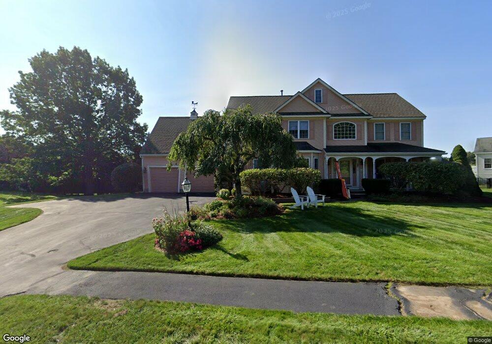
1 Birchwood Dr Westford, MA 01886
Estimated Value: $1,282,242 - $1,496,000
4
Beds
3
Baths
3,272
Sq Ft
$429/Sq Ft
Est. Value
About This Home
This home is located at 1 Birchwood Dr, Westford, MA 01886 and is currently estimated at $1,402,061, approximately $428 per square foot. 1 Birchwood Dr is a home located in Middlesex County with nearby schools including Abbot Elementary School, Nabnasset Elementary, and Stony Brook School.
Ownership History
Date
Name
Owned For
Owner Type
Purchase Details
Closed on
Nov 22, 2019
Sold by
Shah Rajiv and Shah Neha
Bought by
Shah Ft and Shah
Current Estimated Value
Purchase Details
Closed on
Aug 18, 2004
Sold by
Mccarthy James W and Mccarthy Lora L
Bought by
Shah Neha and Shah Rajiv
Purchase Details
Closed on
Sep 28, 2000
Sold by
Harrington Thomas M and Harrington Jane C
Bought by
Mccarthy James W and Mccarthy Lora L
Purchase Details
Closed on
Nov 20, 1996
Sold by
Route 40 Dev Corp
Bought by
Harrington Thomas M and Harrington Jane C
Create a Home Valuation Report for This Property
The Home Valuation Report is an in-depth analysis detailing your home's value as well as a comparison with similar homes in the area
Home Values in the Area
Average Home Value in this Area
Purchase History
| Date | Buyer | Sale Price | Title Company |
|---|---|---|---|
| Shah Ft | -- | -- | |
| Shah Neha | $766,000 | -- | |
| Mccarthy James W | $562,500 | -- | |
| Harrington Thomas M | $393,695 | -- | |
| Shah Neha | $766,000 | -- | |
| Mccarthy James W | $562,500 | -- | |
| Harrington Thomas M | $393,695 | -- |
Source: Public Records
Mortgage History
| Date | Status | Borrower | Loan Amount |
|---|---|---|---|
| Previous Owner | Harrington Thomas M | $408,000 | |
| Previous Owner | Harrington Thomas M | $417,000 |
Source: Public Records
Tax History Compared to Growth
Tax History
| Year | Tax Paid | Tax Assessment Tax Assessment Total Assessment is a certain percentage of the fair market value that is determined by local assessors to be the total taxable value of land and additions on the property. | Land | Improvement |
|---|---|---|---|---|
| 2025 | $17,149 | $1,273,100 | $499,900 | $773,200 |
| 2024 | $15,958 | $1,158,900 | $417,100 | $741,800 |
| 2023 | $15,476 | $1,048,500 | $397,300 | $651,200 |
| 2022 | $15,346 | $952,000 | $328,100 | $623,900 |
| 2021 | $14,234 | $855,400 | $328,100 | $527,300 |
| 2020 | $13,634 | $834,900 | $328,100 | $506,800 |
| 2019 | $13,183 | $796,100 | $328,100 | $468,000 |
| 2018 | $12,881 | $796,100 | $328,100 | $468,000 |
| 2017 | $12,242 | $746,000 | $328,100 | $417,900 |
| 2016 | $11,954 | $733,400 | $312,700 | $420,700 |
| 2015 | $11,774 | $725,000 | $303,200 | $421,800 |
| 2014 | $11,487 | $692,000 | $301,100 | $390,900 |
Source: Public Records
Map
Nearby Homes
- 3 Loon Way
- 9 Loon Way
- 8 Loon Way
- 55 Lawson Rd
- 427 Groton Rd
- 2 Alder Point Unit 2
- 5 Fawn Rd
- 16 Shipley Cir
- 1 Appian Way
- 36 Elm Rd
- 3 Blue Heron Dr
- 10 Gassett Rd
- 26 N Hill Rd
- 6 Lady Constance Way
- 6 Lady Constance Way Unit 21
- 239 Groton Rd
- 4 Lady Constance Way Unit 20
- Copley Plan at Wendell Place
- Williamstown Plan at Wendell Place
- 8 Hammock Dr Unit 8