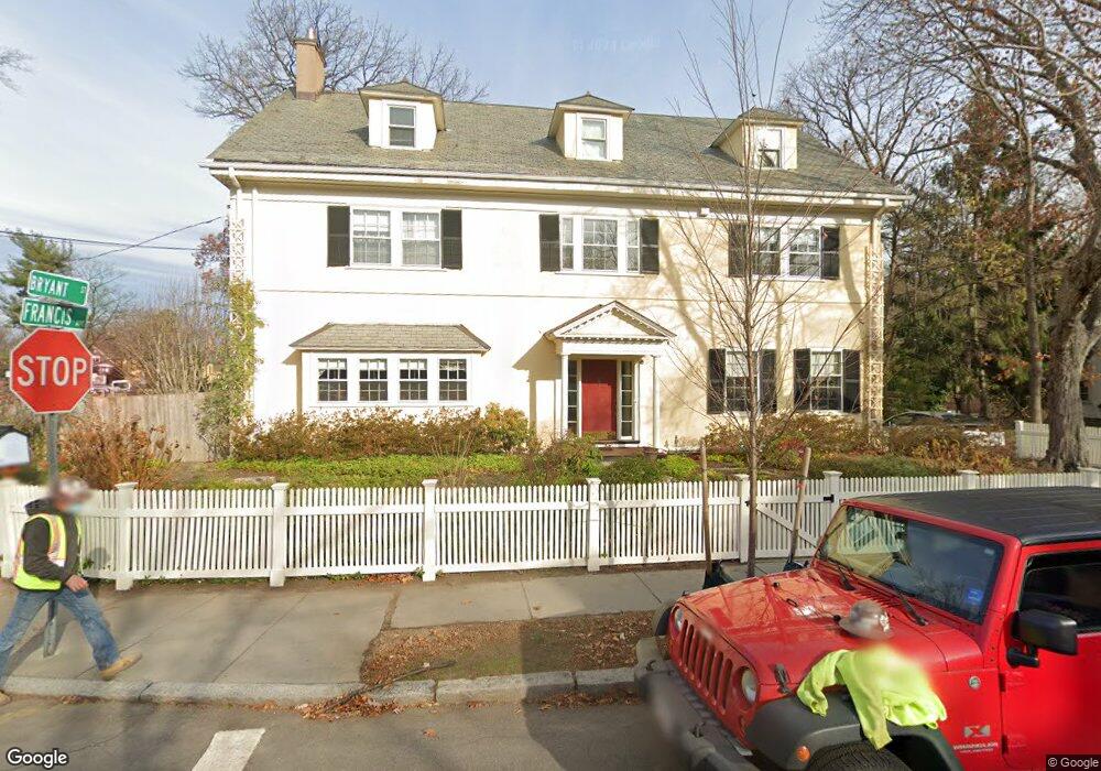
1 Bryant St Cambridge, MA 02138
Baldwin NeighborhoodEstimated Value: $4,597,000 - $5,525,723
6
Beds
5
Baths
5,946
Sq Ft
$869/Sq Ft
Est. Value
About This Home
This home is located at 1 Bryant St, Cambridge, MA 02138 and is currently estimated at $5,167,241, approximately $869 per square foot. 1 Bryant St is a home located in Middlesex County with nearby schools including Saint Theresa School and Saint Paul's Choir School.
Ownership History
Date
Name
Owned For
Owner Type
Purchase Details
Closed on
Dec 23, 2014
Sold by
Mcelroy Michael B and Mcelroy Angela V
Bought by
Angela V Mcelroy Ret
Current Estimated Value
Purchase Details
Closed on
Jul 3, 1986
Bought by
Mcelroy Angela
Create a Home Valuation Report for This Property
The Home Valuation Report is an in-depth analysis detailing your home's value as well as a comparison with similar homes in the area
Home Values in the Area
Average Home Value in this Area
Purchase History
| Date | Buyer | Sale Price | Title Company |
|---|---|---|---|
| Angela V Mcelroy Ret | -- | -- | |
| Mcelroy Angela | $760,000 | -- |
Source: Public Records
Mortgage History
| Date | Status | Borrower | Loan Amount |
|---|---|---|---|
| Previous Owner | Mcelroy Angela | $347,910 | |
| Previous Owner | Mcelroy Angela | $325,000 | |
| Previous Owner | Mcelroy Angela | $400,000 |
Source: Public Records
Tax History Compared to Growth
Tax History
| Year | Tax Paid | Tax Assessment Tax Assessment Total Assessment is a certain percentage of the fair market value that is determined by local assessors to be the total taxable value of land and additions on the property. | Land | Improvement |
|---|---|---|---|---|
| 2025 | $28,391 | $4,471,100 | $2,191,400 | $2,279,700 |
| 2024 | $26,017 | $4,394,700 | $2,212,700 | $2,182,000 |
| 2023 | $24,209 | $4,131,200 | $2,244,800 | $1,886,400 |
| 2022 | $22,066 | $3,727,400 | $2,057,600 | $1,669,800 |
| 2021 | $20,890 | $3,571,000 | $2,018,800 | $1,552,200 |
| 2020 | $19,635 | $3,414,700 | $1,945,000 | $1,469,700 |
| 2019 | $17,733 | $2,985,300 | $1,641,200 | $1,344,100 |
| 2018 | $18,039 | $2,867,900 | $1,616,700 | $1,251,200 |
| 2017 | $17,745 | $2,734,200 | $1,543,300 | $1,190,900 |
| 2016 | $17,463 | $2,498,300 | $1,357,000 | $1,141,300 |
| 2015 | $17,925 | $2,292,200 | $1,273,800 | $1,018,400 |
| 2014 | $18,682 | $2,229,300 | $1,224,800 | $1,004,500 |
Source: Public Records
Map
Nearby Homes
- 55 Museum St
- 55 Museum St Unit 55
- 82 Sacramento St
- 74 Oxford St
- 74 Oxford St Unit 3
- 72 Oxford St Unit 72
- 72 Oxford St
- 37 Mellen St
- 43 Park St Unit 18
- 35 Mellen St
- 89 Kirkland St Unit 89
- 31-33 Mellen St
- 31 Roberts Rd
- 13 Roberts Rd
- 1657 Cambridge St
- 555 Somerville Ave Unit 1
- 555 Somerville Ave Unit 3
- 555 Somerville Ave Unit 2
- 33 Line St Unit 1
- 22 Lowell St Unit 3
- 1 Bryant St Unit 2
- 1 Bryant St Unit 1A
- 4 Bryant St
- 109 Irving St
- 30 Francis Ave
- 30 Francis Ave Unit 30
- 23 Francis Ave
- 107 Irving St
- 107 Irving St Unit 107
- 60 Francis Ave
- 24 Francis Ave
- 133 Irving St
- 21 Francis Ave
- 53 Francis Ave
- 114 Irving St
- 105 Irving St Unit Top
- 105 Irving St
- 105 Irving St Unit 3
- 64 Francis Ave
- 57 Francis Ave