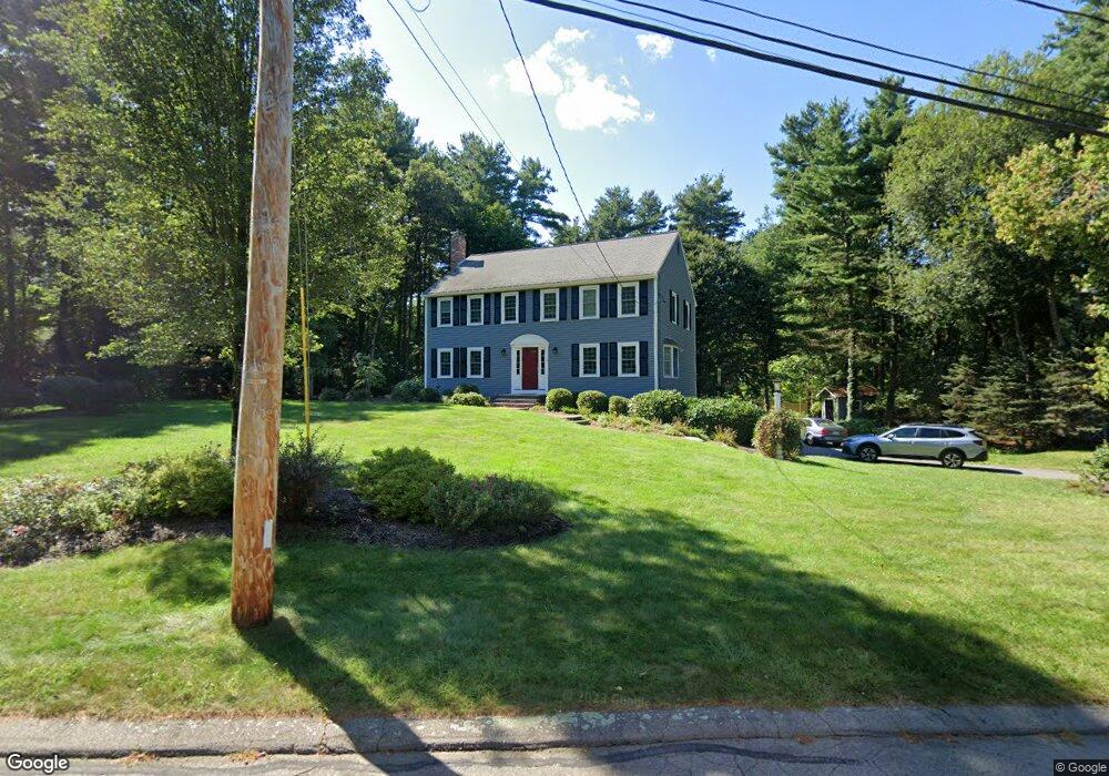
1 Chickadee Dr Norfolk, MA 02056
Estimated Value: $774,567 - $1,301,000
4
Beds
3
Baths
2,240
Sq Ft
$414/Sq Ft
Est. Value
About This Home
This home is located at 1 Chickadee Dr, Norfolk, MA 02056 and is currently estimated at $928,142, approximately $414 per square foot. 1 Chickadee Dr is a home located in Norfolk County with nearby schools including H. Olive Day School and Freeman-Kennedy School.
Ownership History
Date
Name
Owned For
Owner Type
Purchase Details
Closed on
Oct 17, 2012
Sold by
Silvestri Elizabeth M and Silvestri Joseph N
Bought by
Silvestri Elizabeth M
Current Estimated Value
Home Financials for this Owner
Home Financials are based on the most recent Mortgage that was taken out on this home.
Original Mortgage
$250,000
Outstanding Balance
$41,537
Interest Rate
3.57%
Mortgage Type
New Conventional
Estimated Equity
$886,605
Purchase Details
Closed on
Apr 2, 1996
Sold by
Hill Craig R and Hill Nadine M
Bought by
Silvestri Joseph N and Silvestri Elizabeth M
Purchase Details
Closed on
Mar 23, 1987
Sold by
Davis Raymond R
Bought by
Hill Craig R
Create a Home Valuation Report for This Property
The Home Valuation Report is an in-depth analysis detailing your home's value as well as a comparison with similar homes in the area
Home Values in the Area
Average Home Value in this Area
Purchase History
| Date | Buyer | Sale Price | Title Company |
|---|---|---|---|
| Silvestri Elizabeth M | -- | -- | |
| Silvestri Elizabeth M | -- | -- | |
| Silvestri Joseph N | $253,000 | -- | |
| Silvestri Elizabeth M | -- | -- | |
| Silvestri Joseph N | $253,000 | -- | |
| Hill Craig R | $256,000 | -- |
Source: Public Records
Mortgage History
| Date | Status | Borrower | Loan Amount |
|---|---|---|---|
| Open | Silvestri Elizabeth M | $250,000 | |
| Closed | Hill Craig R | $250,000 |
Source: Public Records
Tax History
| Year | Tax Paid | Tax Assessment Tax Assessment Total Assessment is a certain percentage of the fair market value that is determined by local assessors to be the total taxable value of land and additions on the property. | Land | Improvement |
|---|---|---|---|---|
| 2025 | $10,096 | $632,200 | $192,800 | $439,400 |
| 2024 | $9,572 | $614,800 | $196,400 | $418,400 |
| 2023 | $9,163 | $558,400 | $196,400 | $362,000 |
| 2022 | $8,698 | $477,900 | $184,400 | $293,500 |
| 2021 | $8,747 | $486,200 | $190,400 | $295,800 |
| 2020 | $8,940 | $479,600 | $191,500 | $288,100 |
| 2019 | $8,615 | $471,000 | $191,500 | $279,500 |
| 2018 | $8,467 | $454,700 | $200,900 | $253,800 |
| 2017 | $8,343 | $457,900 | $200,900 | $257,000 |
| 2016 | $8,282 | $458,100 | $206,100 | $252,000 |
| 2015 | $7,977 | $451,700 | $196,400 | $255,300 |
| 2014 | $7,715 | $442,600 | $196,400 | $246,200 |
Source: Public Records
Map
Nearby Homes
- 23 Fredrickson Rd
- 8 Ridgefield Rd
- 45 Joshua Rd
- 246 Forest Grove Ave
- 7 Keeney Pond Rd
- 0 W Birch Rd
- 19 Waites Crossing
- 13 Waites Crossing
- 0 Toils End Rd
- 50 Reed Fulton Ave Unit Lot 61
- 287 Park St
- 16 Keeney Pond Rd
- 292 Main St
- 14 Waites Crossing
- 9 Elliot Mills Unit 5
- 8 Elliot Mills Unit 30
- 5 Elliot Mills Unit 3
- 7 Elliot Mills Unit 4
- 10 Elliot Mills Unit 29
- 45 Meetinghouse Rd Unit 45
Your Personal Tour Guide
Ask me questions while you tour the home.