
Seller's Agent in 2026
Jeannine Harrington
The Brown Group Realty
(401) 932-7844
16 in this area
61 Total Sales

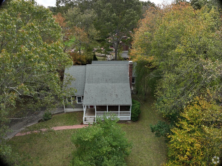
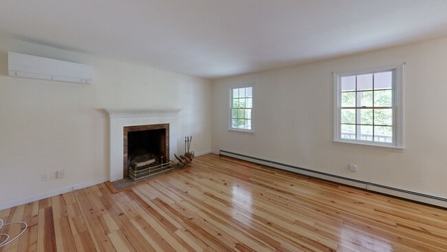


Step inside this charming & spacious Cape Cod home, located just a short drive from one of the most beautiful coastlines in New England! Westerly is renowned for its stunning beaches, seaside golf courses, historic Watch Hill, upscale restaurants, & vibrant downtown. More than just a vacation destination, if offers a unique lifestyle where you can hop on Amtrak to NYC, stroll through historic Wilcox Park, sip elegant cocktails by the carousel, & indulge while enjoying live music along the Pawcatuck River. This home features a versatile layout with multiple living spaces & two main floor primary suites, making it ideal for multigenerational families, or guests. The bonus wing offers a slider to a brand-new deck, its own entrance & parking, enhancing its investment potential. A full enclosed pantry highlights the kitchen, while walk-in closets provide ample storage options. Cozy up to the wood-burning fireplace during the cooler months, & stay comfortable w the mini-split. You'll be impressed by the incredible heated workshop & integrated garage that would delight any handy person. Nestled on 2/3 acre in a desirable Potter Hill neighborhood, this home provides plenty of outdoor space for gardening, entertaining, or simply enjoying the fresh air. Take a moment to embrace the peace & quiet of this tucked-away location that's just minutes from lively downtown Westerly. Don't miss the opportunity to experience the perfect blend of comfort, convenience, and coastal living!
Last Agent to Sell the Property
The Brown Group Realty License #REB.0019028 Listed on: 12/09/2025
Last Buyer's Agent
The Brown Group Realty License #REB.0019028 Listed on: 12/09/2025
| Date | Type | Sale Price | Title Company |
|---|---|---|---|
| Deed | $625,000 | -- | |
| Quit Claim Deed | -- | -- | |
| Quit Claim Deed | -- | None Available | |
| Quit Claim Deed | -- | None Available | |
| Quit Claim Deed | -- | None Available | |
| Warranty Deed | $172,000 | -- | |
| Warranty Deed | $172,000 | -- |
| Date | Status | Loan Amount | Loan Type |
|---|---|---|---|
| Open | $545,000 | New Conventional | |
| Previous Owner | $135,000 | No Value Available | |
| Previous Owner | $212,000 | No Value Available | |
| Previous Owner | $177,000 | No Value Available |
| Date | Event | Price | List to Sale | Price per Sq Ft |
|---|---|---|---|---|
| 01/08/2026 01/08/26 | Sold | $625,000 | -14.3% | $223 / Sq Ft |
| 12/27/2025 12/27/25 | Pending | -- | -- | -- |
| 12/09/2025 12/09/25 | Price Changed | $729,000 | -1.4% | $261 / Sq Ft |
| 12/09/2025 12/09/25 | For Sale | $739,000 | -- | $264 / Sq Ft |
| Year | Tax Paid | Tax Assessment Tax Assessment Total Assessment is a certain percentage of the fair market value that is determined by local assessors to be the total taxable value of land and additions on the property. | Land | Improvement |
|---|---|---|---|---|
| 2025 | $5,017 | $644,900 | $187,200 | $457,700 |
| 2024 | $5,400 | $516,700 | $133,800 | $382,900 |
| 2023 | $5,250 | $516,700 | $133,800 | $382,900 |
| 2022 | $5,219 | $516,700 | $133,800 | $382,900 |
| 2021 | $4,969 | $412,000 | $116,300 | $295,700 |
| 2020 | $4,882 | $412,000 | $116,300 | $295,700 |
| 2019 | $4,837 | $412,000 | $116,300 | $295,700 |
| 2018 | $4,400 | $356,300 | $116,300 | $240,000 |
| 2017 | $4,276 | $356,300 | $116,300 | $240,000 |
| 2016 | $4,276 | $356,300 | $116,300 | $240,000 |
| 2015 | $4,256 | $379,000 | $118,600 | $260,400 |
| 2014 | $4,188 | $379,000 | $118,600 | $260,400 |
Seller's Agent in 2026
Jeannine Harrington
The Brown Group Realty
(401) 932-7844
16 in this area
61 Total Sales
Source: State-Wide MLS
MLS Number: 1401510
APN: WEST-000019-000049L
Disclaimer: Certain information contained herein is derived from information provided by parties other than Homes.com. All information provided is deemed reliable, but is not guaranteed to be accurate and should be independently verified.
![]() IDX information is provided exclusively for personal, non-commercial use, and may not be used for any purpose other than to identify prospective properties consumers may be interested in purchasing. Information is deemed reliable but not guaranteed.
IDX information is provided exclusively for personal, non-commercial use, and may not be used for any purpose other than to identify prospective properties consumers may be interested in purchasing. Information is deemed reliable but not guaranteed.
Copyright © 2026 State-Wide MLS, Inc. All rights reserved.
Ask me questions while you tour the home.