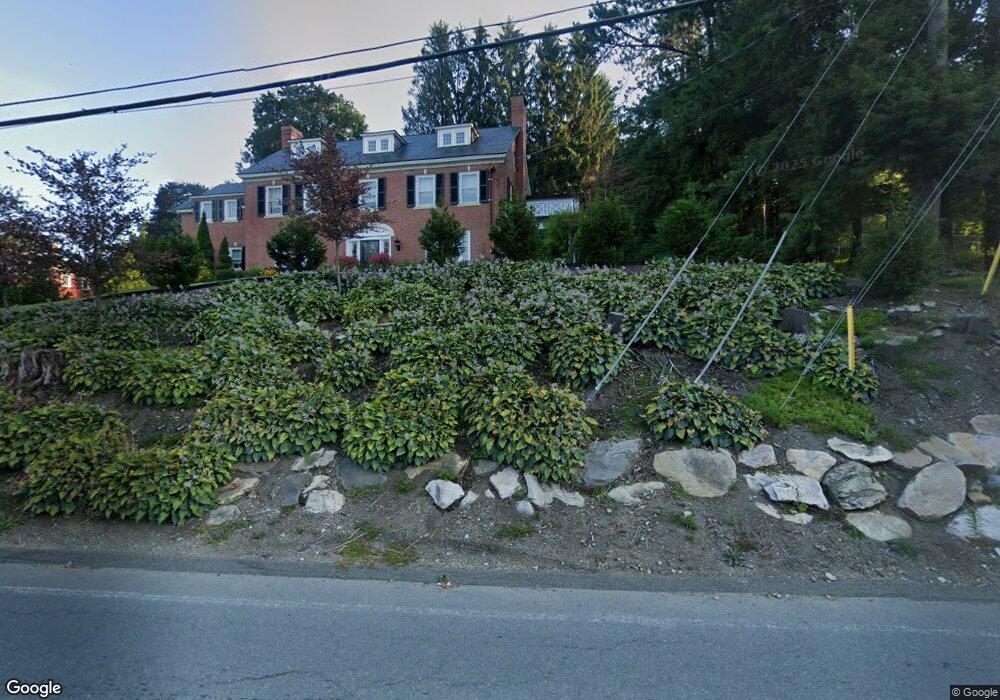
1 Crofut St Pittsfield, MA 01201
Estimated Value: $881,542 - $1,105,000
7
Beds
6
Baths
5,000
Sq Ft
$206/Sq Ft
Est. Value
About This Home
This home is located at 1 Crofut St, Pittsfield, MA 01201 and is currently estimated at $1,030,886, approximately $206 per square foot. 1 Crofut St is a home located in Berkshire County with nearby schools including Egremont Elementary School, Theodore Herberg Middle School, and Pittsfield High School.
Ownership History
Date
Name
Owned For
Owner Type
Purchase Details
Closed on
May 31, 2005
Sold by
French Diana
Bought by
Dobelle Evan S and Dobelle Edith J
Current Estimated Value
Home Financials for this Owner
Home Financials are based on the most recent Mortgage that was taken out on this home.
Original Mortgage
$440,000
Outstanding Balance
$232,362
Interest Rate
5.94%
Mortgage Type
Purchase Money Mortgage
Estimated Equity
$798,524
Purchase Details
Closed on
Aug 17, 1999
Sold by
Ciborski Patricia A
Bought by
French Diana
Purchase Details
Closed on
Jul 30, 1997
Sold by
Regan Edward J and Reagan Louise M
Bought by
Ciborski Patricia A
Purchase Details
Closed on
Apr 18, 1996
Sold by
Beautyman William and Beautyman Daphne R
Bought by
Reagan Edward J and Reagan Louise M
Create a Home Valuation Report for This Property
The Home Valuation Report is an in-depth analysis detailing your home's value as well as a comparison with similar homes in the area
Home Values in the Area
Average Home Value in this Area
Purchase History
| Date | Buyer | Sale Price | Title Company |
|---|---|---|---|
| Dobelle Evan S | $550,000 | -- | |
| Dobelle Evan S | $550,000 | -- | |
| Dobelle Evan S | $550,000 | -- | |
| French Diana | $420,000 | -- | |
| French Diana | $420,000 | -- | |
| Ciborski Patricia A | $327,500 | -- | |
| Ciborski Patricia A | $327,500 | -- | |
| Reagan Edward J | $297,000 | -- | |
| Reagan Edward J | $297,000 | -- |
Source: Public Records
Mortgage History
| Date | Status | Borrower | Loan Amount |
|---|---|---|---|
| Open | Reagan Edward J | $66,700 | |
| Open | Dobelle Evan S | $440,000 | |
| Closed | Dobelle Evan S | $440,000 |
Source: Public Records
Tax History Compared to Growth
Tax History
| Year | Tax Paid | Tax Assessment Tax Assessment Total Assessment is a certain percentage of the fair market value that is determined by local assessors to be the total taxable value of land and additions on the property. | Land | Improvement |
|---|---|---|---|---|
| 2025 | $18,937 | $1,055,600 | $76,200 | $979,400 |
| 2024 | $16,808 | $911,000 | $76,200 | $834,800 |
| 2023 | $15,328 | $836,700 | $76,200 | $760,500 |
| 2022 | $13,677 | $736,900 | $76,200 | $660,700 |
| 2021 | $12,072 | $627,100 | $76,200 | $550,900 |
| 2020 | $11,990 | $608,300 | $76,200 | $532,100 |
| 2019 | $12,306 | $633,700 | $76,200 | $557,500 |
| 2018 | $12,272 | $613,300 | $76,200 | $537,100 |
| 2017 | $11,894 | $605,900 | $81,200 | $524,700 |
| 2016 | $11,382 | $606,700 | $81,200 | $525,500 |
| 2015 | $10,957 | $606,700 | $81,200 | $525,500 |
Source: Public Records
Map
Nearby Homes
- 68 Colt Rd
- 89 Crofut St
- 247 South St
- 31 Henry Ave
- 96 Boylston St
- 261 Pomeroy Ave
- 121 Wendell Ave
- 133 Pomeroy Ave
- 18 Velma Ave
- 20, 26, 30 E Housatonic St
- 32 Velma Ave
- 92 W Housatonic St
- 50 W Housatonic St
- 79 Center St
- 200 W Housatonic St Unit 16
- 127 Gamwell Ave
- 61 Pomeroy Ave
- 55 Pomeroy Ave Unit 6
- 71 S Church St Unit S102
- 174 Cole Ave