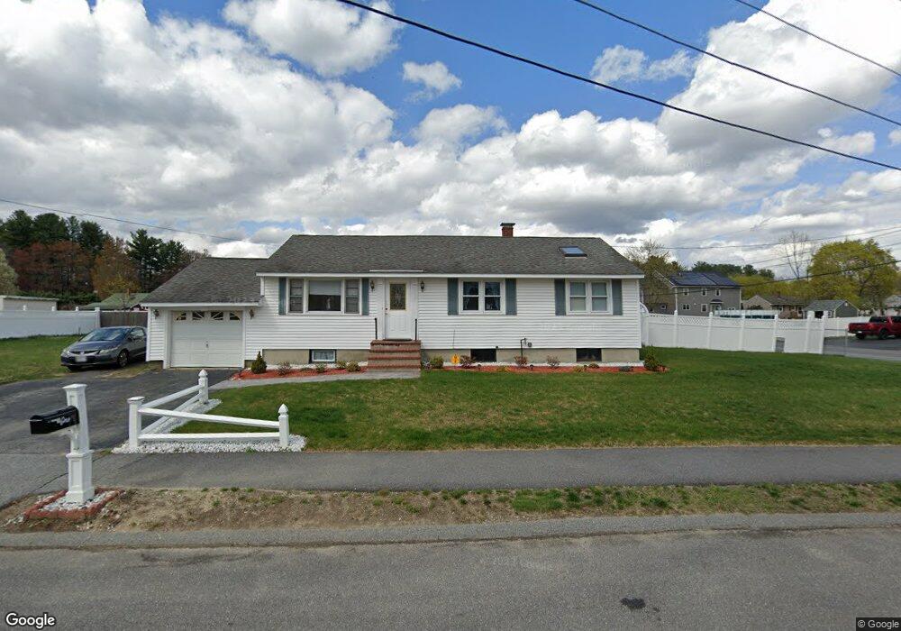
1 David Rd Billerica, MA 01821
Estimated Value: $598,910 - $634,000
3
Beds
2
Baths
1,652
Sq Ft
$369/Sq Ft
Est. Value
About This Home
This home is located at 1 David Rd, Billerica, MA 01821 and is currently estimated at $608,978, approximately $368 per square foot. 1 David Rd is a home located in Middlesex County with nearby schools including Billerica Memorial High School and Knowledge Beginnings South.
Ownership History
Date
Name
Owned For
Owner Type
Purchase Details
Closed on
Jun 14, 2017
Sold by
Cole Karen L
Bought by
Kearney Paul W
Current Estimated Value
Purchase Details
Closed on
May 6, 2005
Sold by
Cole Karen L and Kearney Paul W
Bought by
Cole Karen L and Kearney Paul W
Purchase Details
Closed on
Jun 30, 1993
Sold by
Terpstra Timothy J and Lodi Peter
Bought by
Kearney Paul and Cole Karen
Home Financials for this Owner
Home Financials are based on the most recent Mortgage that was taken out on this home.
Original Mortgage
$112,800
Interest Rate
7.46%
Mortgage Type
Purchase Money Mortgage
Purchase Details
Closed on
Jun 30, 1989
Sold by
Weiss Joseph
Bought by
Terpstra Timothy
Home Financials for this Owner
Home Financials are based on the most recent Mortgage that was taken out on this home.
Original Mortgage
$136,800
Interest Rate
10.56%
Mortgage Type
Purchase Money Mortgage
Create a Home Valuation Report for This Property
The Home Valuation Report is an in-depth analysis detailing your home's value as well as a comparison with similar homes in the area
Home Values in the Area
Average Home Value in this Area
Purchase History
| Date | Buyer | Sale Price | Title Company |
|---|---|---|---|
| Kearney Paul W | $165,000 | -- | |
| Cole Karen L | -- | -- | |
| Kearney Paul | $141,000 | -- | |
| Terpstra Timothy | $152,000 | -- |
Source: Public Records
Mortgage History
| Date | Status | Borrower | Loan Amount |
|---|---|---|---|
| Previous Owner | Terpstra Timothy | $112,800 | |
| Previous Owner | Terpstra Timothy | $136,800 |
Source: Public Records
Tax History Compared to Growth
Tax History
| Year | Tax Paid | Tax Assessment Tax Assessment Total Assessment is a certain percentage of the fair market value that is determined by local assessors to be the total taxable value of land and additions on the property. | Land | Improvement |
|---|---|---|---|---|
| 2025 | $5,509 | $484,500 | $285,400 | $199,100 |
| 2024 | $5,260 | $465,900 | $276,400 | $189,500 |
| 2023 | $5,192 | $437,400 | $251,500 | $185,900 |
| 2022 | $4,744 | $375,300 | $214,900 | $160,400 |
| 2021 | $116,611 | $342,000 | $188,700 | $153,300 |
| 2020 | $20 | $334,600 | $181,300 | $153,300 |
| 2019 | $4,345 | $322,300 | $181,300 | $141,000 |
| 2018 | $4,102 | $289,100 | $161,200 | $127,900 |
| 2017 | $3,900 | $276,800 | $159,500 | $117,300 |
| 2016 | $3,862 | $273,100 | $155,800 | $117,300 |
| 2015 | $3,757 | $267,600 | $151,100 | $116,500 |
| 2014 | $3,783 | $264,700 | $146,400 | $118,300 |
Source: Public Records
Map
Nearby Homes
- 6 Magnolia Ave
- 9 Jenkins Dr
- 79 Bridle Rd
- 7 Bridge St Unit 11
- 19 Shedd Rd
- 12 Stoney Dr
- 21 Shedd Rd
- 15 Blades Cir
- 37 Trifiro Rd
- 23 Salem Rd
- 175 Pollard St
- 140 Pollard St
- Map29-14-1 Rangeway Rd
- 216 Rangeway Rd Unit 192
- 14 Elsie Ave
- 20 Pollard St
- 13 Parker St
- 218 Rangeway Rd Unit 261
- 405 Boston Rd Unit 2
- 48 Old Elm St