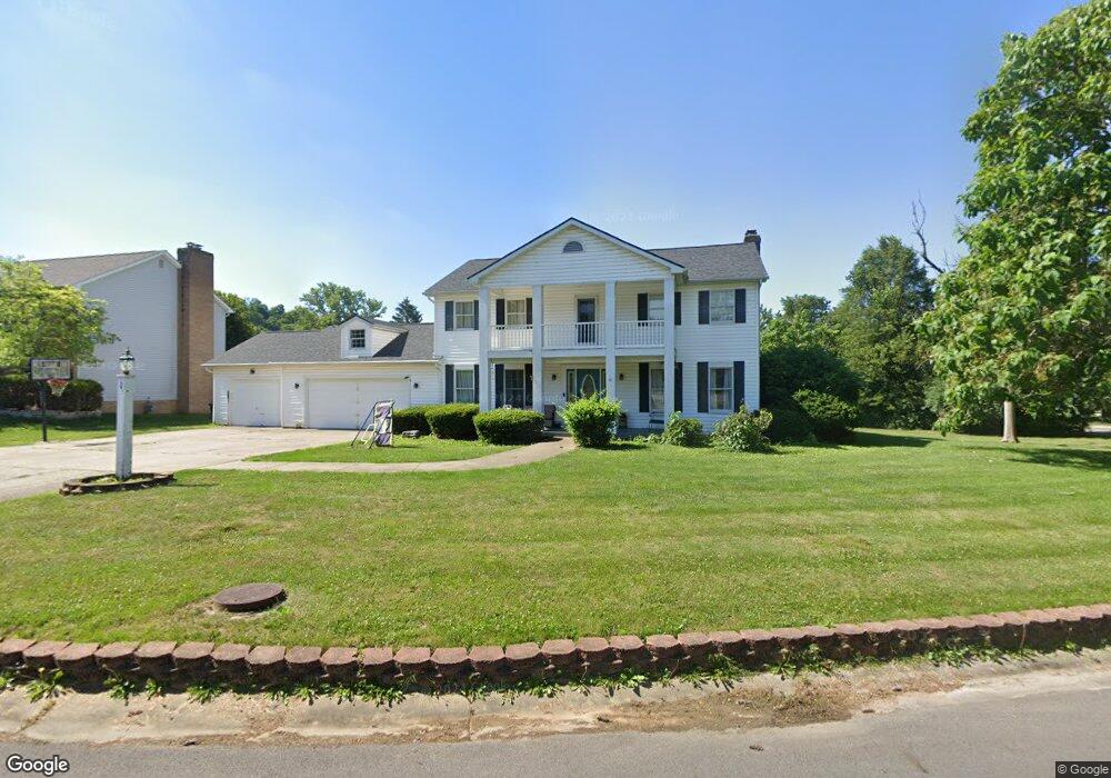
1 Falcon Dr Chillicothe, OH 45601
Estimated Value: $403,410 - $474,000
4
Beds
4
Baths
2,496
Sq Ft
$178/Sq Ft
Est. Value
About This Home
This home is located at 1 Falcon Dr, Chillicothe, OH 45601 and is currently estimated at $443,103, approximately $177 per square foot. 1 Falcon Dr is a home located in Ross County with nearby schools including Unioto Elementary School, Unioto Middle School, and Unioto High School.
Ownership History
Date
Name
Owned For
Owner Type
Purchase Details
Closed on
May 24, 2016
Sold by
Thompson Troy L
Bought by
Doughty Kelly J and Doughty Johnny R
Current Estimated Value
Home Financials for this Owner
Home Financials are based on the most recent Mortgage that was taken out on this home.
Original Mortgage
$185,576
Outstanding Balance
$147,345
Interest Rate
3.58%
Mortgage Type
New Conventional
Estimated Equity
$295,758
Purchase Details
Closed on
Oct 16, 2007
Sold by
Thompson Sherry L
Bought by
Thompson Troy L
Create a Home Valuation Report for This Property
The Home Valuation Report is an in-depth analysis detailing your home's value as well as a comparison with similar homes in the area
Home Values in the Area
Average Home Value in this Area
Purchase History
| Date | Buyer | Sale Price | Title Company |
|---|---|---|---|
| Doughty Kelly J | $189,000 | Northwest Title Family Of Co | |
| Thompson Troy L | -- | None Available |
Source: Public Records
Mortgage History
| Date | Status | Borrower | Loan Amount |
|---|---|---|---|
| Open | Doughty Kelly J | $185,576 |
Source: Public Records
Tax History
| Year | Tax Paid | Tax Assessment Tax Assessment Total Assessment is a certain percentage of the fair market value that is determined by local assessors to be the total taxable value of land and additions on the property. | Land | Improvement |
|---|---|---|---|---|
| 2024 | $4,616 | $123,940 | $14,670 | $109,270 |
| 2023 | $4,616 | $123,940 | $14,670 | $109,270 |
| 2022 | $4,708 | $123,940 | $14,670 | $109,270 |
| 2021 | $3,376 | $88,110 | $10,710 | $77,400 |
| 2020 | $3,394 | $88,110 | $10,710 | $77,400 |
| 2019 | $3,346 | $88,110 | $10,710 | $77,400 |
| 2018 | $3,460 | $89,120 | $9,720 | $79,400 |
| 2017 | $3,391 | $89,120 | $9,720 | $79,400 |
| 2016 | $3,415 | $89,120 | $9,720 | $79,400 |
| 2015 | $3,261 | $85,150 | $9,720 | $75,430 |
| 2014 | $3,186 | $85,150 | $9,720 | $75,430 |
| 2013 | $3,202 | $85,150 | $9,720 | $75,430 |
Source: Public Records
Map
Nearby Homes
- 239 Almahurst Dr
- 5 Shawnee Dr
- 4 Ridge Dr
- 18 Ridge Dr
- 44 Banyas Blvd
- 53 Fruithill Dr
- 53 Fruit Hill Dr
- 4 Becky Ln
- 26 Tecumseh Dr
- 1310 Western Ave
- 15 Windsor Dr
- 1295 Randall Ct
- 240 Independence Dr Unit B10
- 231 Saint Claire Dr
- 1271 Porter Dr
- 222 Saint Claire Dr
- 1210 Dolphin St
- 320 Summerhill Dr
- 1041 Edgewood Dr
- 622 Seminole Rd
Your Personal Tour Guide
Ask me questions while you tour the home.