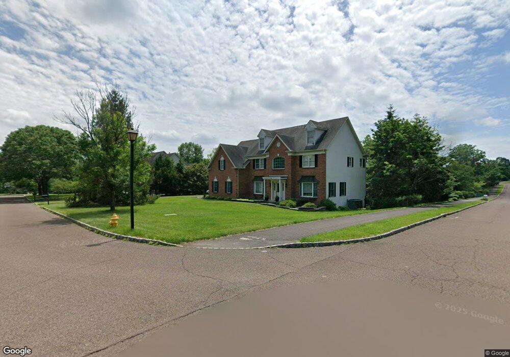
1 Flint Cir Doylestown, PA 18901
Estimated Value: $1,121,564 - $1,228,000
4
Beds
4
Baths
4,205
Sq Ft
$279/Sq Ft
Est. Value
About This Home
This home is located at 1 Flint Cir, Doylestown, PA 18901 and is currently estimated at $1,173,641, approximately $279 per square foot. 1 Flint Cir is a home located in Bucks County with nearby schools including Kutz Elementary School, Lenape Middle School, and Central Bucks High School-West.
Ownership History
Date
Name
Owned For
Owner Type
Purchase Details
Closed on
Jun 12, 2001
Sold by
The Cutler Group Inc
Bought by
Beach William F and Beach Lynn G Brosius
Current Estimated Value
Home Financials for this Owner
Home Financials are based on the most recent Mortgage that was taken out on this home.
Original Mortgage
$355,000
Outstanding Balance
$135,819
Interest Rate
7.2%
Estimated Equity
$1,037,822
Create a Home Valuation Report for This Property
The Home Valuation Report is an in-depth analysis detailing your home's value as well as a comparison with similar homes in the area
Home Values in the Area
Average Home Value in this Area
Purchase History
| Date | Buyer | Sale Price | Title Company |
|---|---|---|---|
| Beach William F | $459,175 | -- |
Source: Public Records
Mortgage History
| Date | Status | Borrower | Loan Amount |
|---|---|---|---|
| Open | Beach William F | $355,000 |
Source: Public Records
Tax History Compared to Growth
Tax History
| Year | Tax Paid | Tax Assessment Tax Assessment Total Assessment is a certain percentage of the fair market value that is determined by local assessors to be the total taxable value of land and additions on the property. | Land | Improvement |
|---|---|---|---|---|
| 2025 | $11,892 | $67,200 | $7,120 | $60,080 |
| 2024 | $11,892 | $67,200 | $7,120 | $60,080 |
| 2023 | $11,339 | $67,200 | $7,120 | $60,080 |
| 2022 | $11,213 | $67,200 | $7,120 | $60,080 |
| 2021 | $10,982 | $67,200 | $7,120 | $60,080 |
| 2020 | $10,932 | $67,200 | $7,120 | $60,080 |
| 2019 | $10,814 | $67,200 | $7,120 | $60,080 |
| 2018 | $10,781 | $67,200 | $7,120 | $60,080 |
| 2017 | $10,697 | $67,200 | $7,120 | $60,080 |
| 2016 | $10,629 | $67,200 | $7,120 | $60,080 |
| 2015 | -- | $67,200 | $7,120 | $60,080 |
| 2014 | -- | $67,200 | $7,120 | $60,080 |
Source: Public Records
Map
Nearby Homes
- 137 Wells Rd
- 222 Windsor Way
- 82 Avalon Ct Unit 2005
- 60 Quarry Rd
- 1101 Deerfield Ln
- 20 Woodstone Dr
- 125 Edison Furlong Rd
- 9 Mill Creek Dr
- 78 Tower Hill Rd
- 137 Pebble Woods Dri Pebble Woods Dr
- 114 Progress Dr
- 259 W Ashland St
- 403 S Main St Unit S201
- 612 Bethel Ln Unit THE ROOSEVELT PLAN
- 195 Lafayette St
- 45 Bedford Ave
- 422 Fordhook Rd
- 450 Ford Hook Rd
- 432 Ford Hook Rd
- 2320 Turk Rd