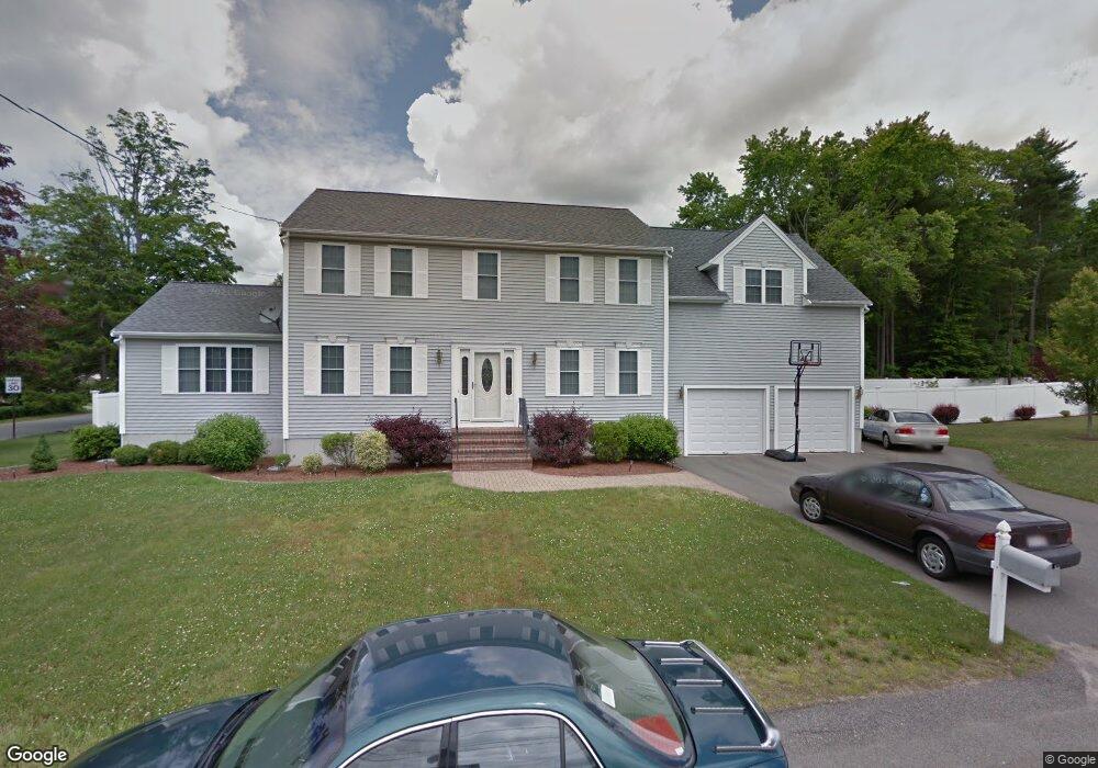
1 Fox Way Whitman, MA 02382
Estimated Value: $774,000 - $837,000
4
Beds
3
Baths
2,796
Sq Ft
$286/Sq Ft
Est. Value
About This Home
This home is located at 1 Fox Way, Whitman, MA 02382 and is currently estimated at $800,939, approximately $286 per square foot. 1 Fox Way is a home located in Plymouth County with nearby schools including St Bridget School.
Ownership History
Date
Name
Owned For
Owner Type
Purchase Details
Closed on
Mar 22, 2005
Sold by
R & R Home Constr Corp
Bought by
Meyers Jeffrey S and Meyers Anna M
Current Estimated Value
Purchase Details
Closed on
Feb 28, 2005
Sold by
Coles Matthew R and Collins-Coles Jennifer
Bought by
R & R Home Constr Corp
Purchase Details
Closed on
Jun 1, 2004
Sold by
R & R Home Constr Corp
Bought by
Coles Matthew R and Collins-Coles Jennifer
Purchase Details
Closed on
Apr 1, 2003
Sold by
Stone Aletta A
Bought by
R & R Home Constr Corp
Create a Home Valuation Report for This Property
The Home Valuation Report is an in-depth analysis detailing your home's value as well as a comparison with similar homes in the area
Home Values in the Area
Average Home Value in this Area
Purchase History
| Date | Buyer | Sale Price | Title Company |
|---|---|---|---|
| Meyers Jeffrey S | $435,000 | -- | |
| R & R Home Constr Corp | -- | -- | |
| Coles Matthew R | -- | -- | |
| R & R Home Constr Corp | $360,000 | -- |
Source: Public Records
Tax History
| Year | Tax Paid | Tax Assessment Tax Assessment Total Assessment is a certain percentage of the fair market value that is determined by local assessors to be the total taxable value of land and additions on the property. | Land | Improvement |
|---|---|---|---|---|
| 2025 | $9,159 | $698,100 | $238,600 | $459,500 |
| 2024 | $8,129 | $638,100 | $231,000 | $407,100 |
| 2023 | $8,066 | $594,400 | $210,400 | $384,000 |
| 2022 | $7,989 | $548,700 | $190,900 | $357,800 |
| 2021 | $7,976 | $514,600 | $159,400 | $355,200 |
| 2020 | $7,852 | $495,400 | $151,800 | $343,600 |
| 2019 | $7,530 | $489,600 | $151,800 | $337,800 |
| 2018 | $7,046 | $440,100 | $143,100 | $297,000 |
| 2017 | $6,638 | $440,200 | $143,100 | $297,100 |
| 2016 | $6,577 | $421,900 | $135,600 | $286,300 |
| 2015 | $6,331 | $405,600 | $119,300 | $286,300 |
Source: Public Records
Map
Nearby Homes
- 214 Winter St
- 10 Proud Foot Way
- 289 Commercial St
- 170 Pleasant St
- 147 South Ave
- 74 Benson St
- 22 Old Coach Rd
- 48 Day St
- 110 South Ave
- 61 Suffolk St
- 8 Laurel St
- 291 Raynor Ave
- 608 Plymouth St
- 22 Howland Trail Unit 34
- 10 Birch Bottom Cir
- 7 Hayford Trail Unit 12
- 5 Hayford Trail Unit 11
- 17 Hayford Trail Unit 12
- 159 Auburn St
- 157 Auburn St Unit 157
- 2 Fox Way
- 272 Winter St
- 294 Franklin St
- 294 Franklin St Unit 2
- 318 Franklin St
- 284 Franklin St
- 3 Fox Way
- 262 Winter St
- 262 Winter St Unit 1
- 6 Fox Way
- 315 Franklin St
- 4 Fox Way
- 265 Winter St
- 324 Franklin St
- 322 Franklin St
- 299 Franklin St
- 289 Franklin St
- 272 Franklin St
- 272 Franklin St Unit 1
- 273 Franklin St
Your Personal Tour Guide
Ask me questions while you tour the home.