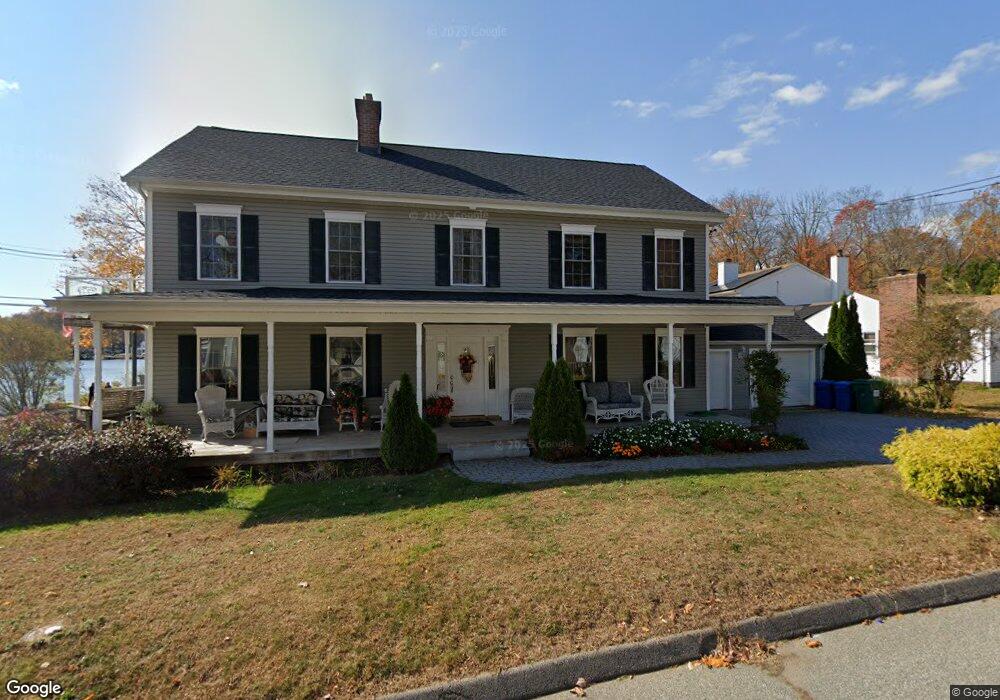
1 Hale Rd East Hampton, CT 06424
Estimated Value: $565,000 - $1,078,000
3
Beds
4
Baths
2,568
Sq Ft
$290/Sq Ft
Est. Value
About This Home
This home is located at 1 Hale Rd, East Hampton, CT 06424 and is currently estimated at $744,698, approximately $289 per square foot. 1 Hale Rd is a home located in Middlesex County with nearby schools including Memorial School, Center Elementary School, and East Hampton Middle School.
Ownership History
Date
Name
Owned For
Owner Type
Purchase Details
Closed on
Jan 3, 2024
Sold by
Tanner Sue A
Bought by
Sue Tanner Ret and Tanner
Current Estimated Value
Purchase Details
Closed on
Oct 19, 2005
Sold by
2-Twenty Llc
Bought by
Tanner Dennis D and Tanner Sue A
Home Financials for this Owner
Home Financials are based on the most recent Mortgage that was taken out on this home.
Original Mortgage
$150,000
Interest Rate
5.72%
Mortgage Type
Purchase Money Mortgage
Create a Home Valuation Report for This Property
The Home Valuation Report is an in-depth analysis detailing your home's value as well as a comparison with similar homes in the area
Home Values in the Area
Average Home Value in this Area
Purchase History
| Date | Buyer | Sale Price | Title Company |
|---|---|---|---|
| Sue Tanner Ret | -- | None Available | |
| Sue Tanner Ret | -- | None Available | |
| Tanner Dennis D | $580,000 | -- | |
| Tanner Dennis D | $580,000 | -- |
Source: Public Records
Mortgage History
| Date | Status | Borrower | Loan Amount |
|---|---|---|---|
| Previous Owner | Tanner Dennis D | $150,000 |
Source: Public Records
Tax History
| Year | Tax Paid | Tax Assessment Tax Assessment Total Assessment is a certain percentage of the fair market value that is determined by local assessors to be the total taxable value of land and additions on the property. | Land | Improvement |
|---|---|---|---|---|
| 2025 | $9,578 | $241,200 | $52,060 | $189,140 |
| 2024 | $9,175 | $241,200 | $52,060 | $189,140 |
| 2023 | $8,698 | $241,200 | $52,060 | $189,140 |
| 2022 | $8,360 | $241,200 | $52,060 | $189,140 |
| 2021 | $8,329 | $241,200 | $52,060 | $189,140 |
| 2020 | $7,600 | $229,330 | $35,860 | $193,470 |
| 2019 | $7,922 | $239,050 | $40,490 | $198,560 |
| 2018 | $7,487 | $239,050 | $40,490 | $198,560 |
| 2017 | $7,487 | $239,050 | $40,490 | $198,560 |
| 2016 | $7,038 | $239,050 | $40,490 | $198,560 |
| 2015 | $7,000 | $251,990 | $47,640 | $204,350 |
| 2014 | $6,091 | $251,990 | $47,640 | $204,350 |
Source: Public Records
Map
Nearby Homes
- 2 Hale Rd
- 4 Hale Rd
- 5 Hale Rd
- 0 Mott Hill Rd Unit G684312
- 0 Mott Hill Rd Unit G684899
- 0 Mott Hill Rd Unit G10036196
- 0 Mott Hill Rd Unit G10036172
- 85 Lake Dr
- 6 Hale Rd
- 6 Hale Rd Unit 6
- C-66 Boulder Rd
- 2 Boulder Rd
- 10 Hale Rd
- 11 Hale Rd
- 91 Lake Dr
- 6 Mott Hill Rd
- 7 Candlewood Dr
- 93 Lake Dr
- 13 Hale Rd
- 81 Lake Dr
Your Personal Tour Guide
Ask me questions while you tour the home.