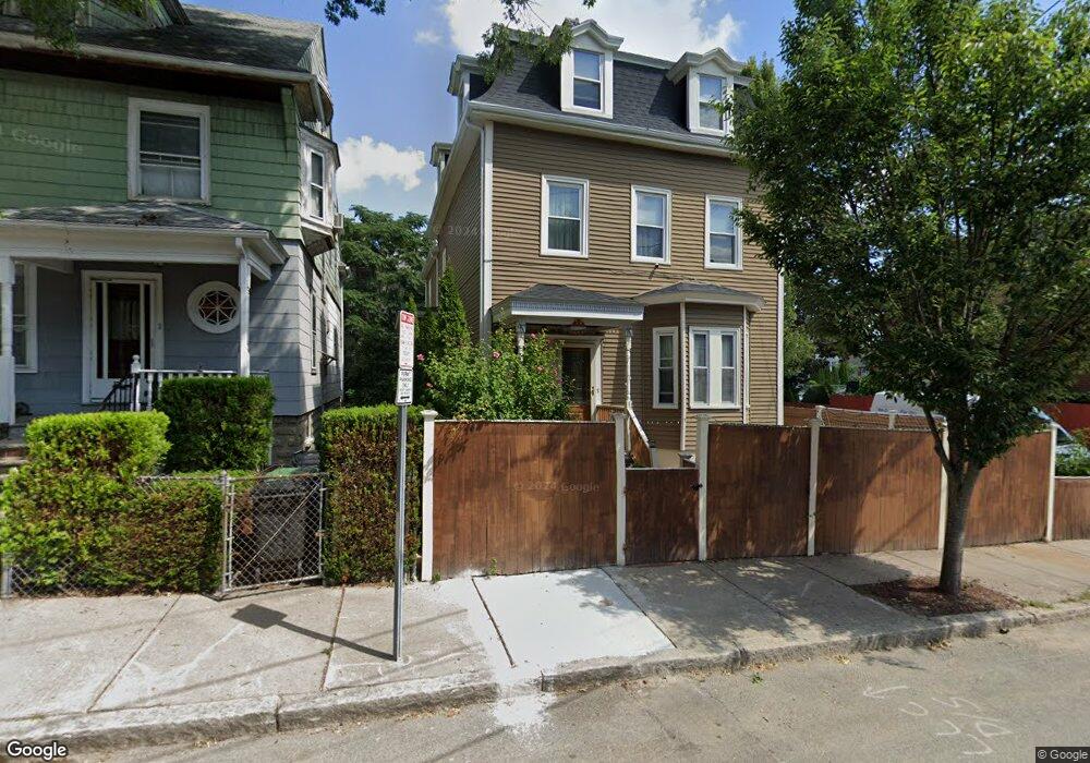
1 Howe St Somerville, MA 02145
Winter Hill NeighborhoodEstimated Value: $959,000 - $1,474,000
5
Beds
4
Baths
2,852
Sq Ft
$420/Sq Ft
Est. Value
About This Home
This home is located at 1 Howe St, Somerville, MA 02145 and is currently estimated at $1,197,638, approximately $419 per square foot. 1 Howe St is a home located in Middlesex County with nearby schools including Somerville High School, Prospect Hill Academy Upper Elementary Campus, and Bright Future Educare Center.
Ownership History
Date
Name
Owned For
Owner Type
Purchase Details
Closed on
Oct 19, 2006
Sold by
Koustomiris Irini G
Bought by
Koustomiris Joanna
Current Estimated Value
Purchase Details
Closed on
Oct 11, 2006
Sold by
Koustomiris George
Bought by
Koustomiris Irini G
Create a Home Valuation Report for This Property
The Home Valuation Report is an in-depth analysis detailing your home's value as well as a comparison with similar homes in the area
Home Values in the Area
Average Home Value in this Area
Purchase History
| Date | Buyer | Sale Price | Title Company |
|---|---|---|---|
| Koustomiris Joanna | $300,000 | -- | |
| Koustomiris Irini G | -- | -- |
Source: Public Records
Tax History
| Year | Tax Paid | Tax Assessment Tax Assessment Total Assessment is a certain percentage of the fair market value that is determined by local assessors to be the total taxable value of land and additions on the property. | Land | Improvement |
|---|---|---|---|---|
| 2025 | $11,166 | $1,023,500 | $400,800 | $622,700 |
| 2024 | $10,393 | $987,900 | $400,800 | $587,100 |
| 2023 | $10,109 | $977,700 | $400,800 | $576,900 |
| 2022 | $9,447 | $928,000 | $381,700 | $546,300 |
| 2021 | $8,856 | $869,100 | $363,500 | $505,600 |
| 2020 | $8,345 | $827,100 | $349,500 | $477,600 |
| 2019 | $7,920 | $736,100 | $296,700 | $439,400 |
| 2018 | $7,392 | $653,600 | $286,200 | $367,400 |
| 2017 | $7,050 | $604,100 | $266,800 | $337,300 |
| 2016 | $6,960 | $555,500 | $230,800 | $324,700 |
| 2015 | $6,658 | $528,000 | $205,800 | $322,200 |
Source: Public Records
Map
Nearby Homes
- 7 Stickney Ave
- 15 Stickney Ave Unit A
- 185 School St
- 13 Richdale Ave Unit 2
- 232 Pearl St
- 59 Dartmouth St Unit A
- 12 Montgomery Ave
- 115 Thurston St Unit I
- 49 Tennyson St Unit 2
- 49 Tennyson St
- 74 Gilman St Unit 1
- 19 Fenwick St Unit 4
- 36 Everett Ave
- 11 Macarthur St Unit B
- 11 Macarthur St Unit A
- 124 Highland Ave Unit 204
- 25 Browning Rd
- 66 Grant St Unit 1
- 19 Everett Ave
- 34 Putnam St
- 1 Howe St Unit 2
- 3 Howe St
- 66C Marshall St Unit 66-C
- 66C Marshall St
- 61 Marshall St
- 7 Howe St
- 66A Marshall St
- 66B Marshall St
- 66 Marshall St Unit 66-C
- 66 Marshall St Unit A
- 66 Marshall St Unit B
- 66 Marshall St Unit C
- 66 Marshall St
- 69 Marshall St Unit 4
- 69 Marshall St Unit 3
- 69 Marshall St Unit 2
- 69 Marshall St Unit 1
- 59 Marshall St Unit 2
- 59 Marshall St Unit 2,1
- 59 Marshall St Unit 59
Your Personal Tour Guide
Ask me questions while you tour the home.