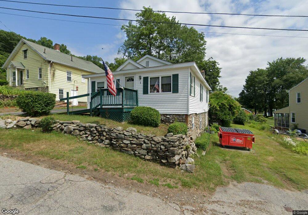
1 Manor Rd Millbury, MA 01527
Estimated Value: $306,000 - $421,000
2
Beds
2
Baths
1,054
Sq Ft
$343/Sq Ft
Est. Value
About This Home
This home is located at 1 Manor Rd, Millbury, MA 01527 and is currently estimated at $361,742, approximately $343 per square foot. 1 Manor Rd is a home located in Worcester County with nearby schools including Elmwood Street Elementary School, Raymond E. Shaw Elementary School, and Millbury Junior/Senior High School.
Ownership History
Date
Name
Owned For
Owner Type
Purchase Details
Closed on
Dec 14, 2004
Sold by
Burke Dorothy J and Burke Irving R
Bought by
Burke James I
Current Estimated Value
Purchase Details
Closed on
Aug 16, 1996
Sold by
Burke James I
Bought by
Burke Dorothy and Burke Irving
Create a Home Valuation Report for This Property
The Home Valuation Report is an in-depth analysis detailing your home's value as well as a comparison with similar homes in the area
Home Values in the Area
Average Home Value in this Area
Purchase History
| Date | Buyer | Sale Price | Title Company |
|---|---|---|---|
| Burke James I | $93,128 | -- | |
| Burke James I | $93,128 | -- | |
| Burke Dorothy | $45,000 | -- | |
| Burke Dorothy | $45,000 | -- |
Source: Public Records
Mortgage History
| Date | Status | Borrower | Loan Amount |
|---|---|---|---|
| Previous Owner | Burke Dorothy | $99,400 | |
| Previous Owner | Burke Dorothy | $100,000 | |
| Previous Owner | Burke Dorothy | $31,000 |
Source: Public Records
Tax History
| Year | Tax Paid | Tax Assessment Tax Assessment Total Assessment is a certain percentage of the fair market value that is determined by local assessors to be the total taxable value of land and additions on the property. | Land | Improvement |
|---|---|---|---|---|
| 2025 | $4,285 | $320,000 | $97,500 | $222,500 |
| 2024 | $3,931 | $297,100 | $90,200 | $206,900 |
| 2023 | $3,620 | $250,500 | $63,200 | $187,300 |
| 2022 | $3,449 | $229,900 | $63,200 | $166,700 |
| 2021 | $3,441 | $223,000 | $63,200 | $159,800 |
| 2020 | $3,271 | $213,400 | $63,200 | $150,200 |
| 2019 | $3,560 | $224,600 | $57,500 | $167,100 |
| 2018 | $1,732 | $194,000 | $57,500 | $136,500 |
| 2017 | $3,074 | $187,100 | $57,500 | $129,600 |
| 2016 | $2,953 | $179,400 | $57,500 | $121,900 |
| 2015 | $2,917 | $177,200 | $61,100 | $116,100 |
| 2014 | $2,686 | $157,100 | $61,100 | $96,000 |
Source: Public Records
Map
Nearby Homes
- 2 Wilson Rd Unit B
- 2 Wilson Rd Unit A
- 25 Upton St
- 48 Macarthur Dr
- 2 Diane St
- 2 Riverlin Pkwy
- 300 Millbury Ave
- 8 Nightview Place
- 12 Irene Ct
- 8 Lincoln Ave
- 17 Lincoln Ave
- 7 Canal St
- 7 Barbara St
- 37-39 Main St
- 457 Granite St
- 0 Worcester Providence Turnpike
- 1459 Grafton Rd
- 11 Maplewood Rd
- 5 Ann Dr Unit 5
- 20 Woodridge Rd
- 5 Manor Rd
- 182 Millbury Ave
- 184 Millbury Ave
- 180 Millbury Ave
- 4 Manor Rd
- 4 Manor Rd
- 7 Manor Rd
- 178 Millbury Ave
- 185 Millbury Ave
- 9 Manor Rd
- 181 Millbury Ave
- 186 Millbury Ave
- 187 Millbury Ave
- 13 Wilson Rd
- 177 Millbury Ave
- 1 Ford Rd
- 11 Wilson Rd
- 188 Millbury Ave
- 188 Millbury Ave Unit 1
- 189 Millbury Ave Unit C
Your Personal Tour Guide
Ask me questions while you tour the home.