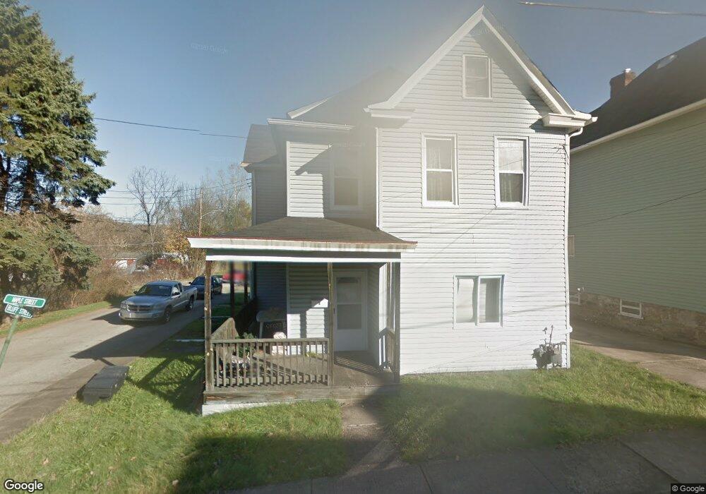
1 Maple St Trafford, PA 15085
Estimated Value: $144,805 - $206,000
3
Beds
1
Bath
1,732
Sq Ft
$98/Sq Ft
Est. Value
About This Home
This home is located at 1 Maple St, Trafford, PA 15085 and is currently estimated at $170,451, approximately $98 per square foot. 1 Maple St is a home located in Allegheny County with nearby schools including Penn Trafford High School.
Ownership History
Date
Name
Owned For
Owner Type
Purchase Details
Closed on
Mar 17, 2023
Sold by
Westmoreland County Tax Claim Bureau Trs
Bought by
New Hmstd Develop Co and Shields
Current Estimated Value
Purchase Details
Closed on
Feb 22, 2023
Sold by
Shields Stanley S
Bought by
New Homestead Development Company
Purchase Details
Closed on
Feb 14, 2017
Sold by
Decenzo Jean and Dicenzo Michael
Bought by
Decenzo Jean and Dicenzo Michael
Purchase Details
Closed on
Feb 10, 2000
Sold by
Shields Stanley S and Shields Donna L
Bought by
Shields Stanley S
Create a Home Valuation Report for This Property
The Home Valuation Report is an in-depth analysis detailing your home's value as well as a comparison with similar homes in the area
Home Values in the Area
Average Home Value in this Area
Purchase History
| Date | Buyer | Sale Price | Title Company |
|---|---|---|---|
| New Homestead Development Company | $1,875 | -- | |
| Decenzo Jean | -- | None Available | |
| Shields Stanley S | -- | -- | |
| New Hmstd Develop Co | -- | -- |
Source: Public Records
Tax History Compared to Growth
Tax History
| Year | Tax Paid | Tax Assessment Tax Assessment Total Assessment is a certain percentage of the fair market value that is determined by local assessors to be the total taxable value of land and additions on the property. | Land | Improvement |
|---|---|---|---|---|
| 2025 | $4,237 | $84,500 | $30,100 | $54,400 |
| 2024 | $4,237 | $84,500 | $30,100 | $54,400 |
| 2023 | $3,341 | $66,500 | $30,100 | $36,400 |
| 2022 | $3,412 | $66,500 | $30,100 | $36,400 |
| 2021 | $315 | $66,500 | $30,100 | $36,400 |
| 2020 | $3,439 | $66,500 | $30,100 | $36,400 |
| 2019 | $3,458 | $66,500 | $30,100 | $36,400 |
| 2018 | $315 | $66,500 | $30,100 | $36,400 |
| 2017 | $3,335 | $66,500 | $30,100 | $36,400 |
| 2016 | $315 | $66,500 | $30,100 | $36,400 |
| 2015 | $315 | $84,500 | $30,100 | $54,400 |
| 2014 | $400 | $84,500 | $30,100 | $54,400 |
Source: Public Records
Map
Nearby Homes
- 107 Cavitt Ave
- 230 Cavitt Ave
- 204 2nd St
- 514 Cavitt Ave
- 522 Cavitt Ave
- 601 Brinton Ave
- 403 Gilmore Ave
- 811 5th St
- 1870 Haymaker Rd
- 670 Division St
- 642 Irwin St
- 582 Forest Oaks Trail
- 200 Timber Dr
- 419 Bellvue St
- 1718 Howell St
- 320 Penn Lear Ct
- . Old Ramsey Rd
- 876 Sylvan Ave
- 2047 Haymaker Rd
- 103 Jeanine Ct