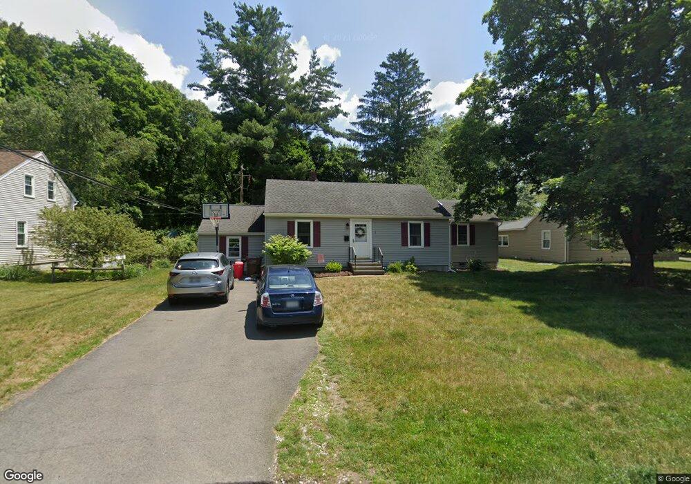
1 Marion Rd Delmar, NY 12054
Estimated Value: $296,000 - $340,000
2
Beds
1
Bath
1,000
Sq Ft
$313/Sq Ft
Est. Value
About This Home
This home is located at 1 Marion Rd, Delmar, NY 12054 and is currently estimated at $312,751, approximately $312 per square foot. 1 Marion Rd is a home located in Albany County with nearby schools including St. Thomas the Apostle School and Mt. Moriah Academy.
Ownership History
Date
Name
Owned For
Owner Type
Purchase Details
Closed on
Jul 28, 2009
Sold by
Hall Paul
Bought by
Sparks Trevor I and Sparks Maria C
Current Estimated Value
Home Financials for this Owner
Home Financials are based on the most recent Mortgage that was taken out on this home.
Original Mortgage
$166,920
Interest Rate
5.31%
Purchase Details
Closed on
Oct 14, 2004
Sold by
Lowenski Catherine S
Bought by
Hall Paul
Purchase Details
Closed on
Mar 30, 2002
Sold by
Est Sullivan William J Jr
Bought by
Lowenski Catherine S
Create a Home Valuation Report for This Property
The Home Valuation Report is an in-depth analysis detailing your home's value as well as a comparison with similar homes in the area
Home Values in the Area
Average Home Value in this Area
Purchase History
| Date | Buyer | Sale Price | Title Company |
|---|---|---|---|
| Sparks Trevor I | $170,000 | None Available | |
| Hall Paul | -- | Samuel Whiting | |
| Lowenski Catherine S | -- | -- |
Source: Public Records
Mortgage History
| Date | Status | Borrower | Loan Amount |
|---|---|---|---|
| Previous Owner | Sparks Trevor I | $166,920 |
Source: Public Records
Tax History Compared to Growth
Tax History
| Year | Tax Paid | Tax Assessment Tax Assessment Total Assessment is a certain percentage of the fair market value that is determined by local assessors to be the total taxable value of land and additions on the property. | Land | Improvement |
|---|---|---|---|---|
| 2024 | $5,082 | $170,000 | $60,500 | $109,500 |
| 2023 | $4,887 | $170,000 | $60,500 | $109,500 |
| 2022 | $4,737 | $170,000 | $60,500 | $109,500 |
| 2021 | $4,761 | $170,000 | $60,500 | $109,500 |
| 2020 | $4,731 | $170,000 | $60,500 | $109,500 |
| 2019 | $4,627 | $170,000 | $60,500 | $109,500 |
| 2018 | $4,615 | $170,000 | $60,500 | $109,500 |
| 2017 | $4,535 | $170,000 | $60,500 | $109,500 |
| 2016 | $4,535 | $170,000 | $60,500 | $109,500 |
| 2015 | -- | $170,000 | $60,500 | $109,500 |
| 2014 | -- | $170,000 | $60,500 | $109,500 |
Source: Public Records
Map
Nearby Homes
- 7 Merrifield Place
- 484 Kenwood Ave
- 20 Gardner Terrace
- 114 North St
- 15 Roweland Ave
- 358 Kenwood Ave
- 21 Roweland Ave
- 481 Huron Rd
- 64 Winne Rd
- 515 Delaware Ave
- 29 Bennett Terrace
- 531 Delaware Ave
- 19 Orchard St
- 5 Morningside Dr
- 47 Oldox Rd
- 532 Wayne Place
- 616 Kenwood Ave
- 618 Kenwood Ave
- 10 Lincoln Ave
- 122 Marlboro Rd