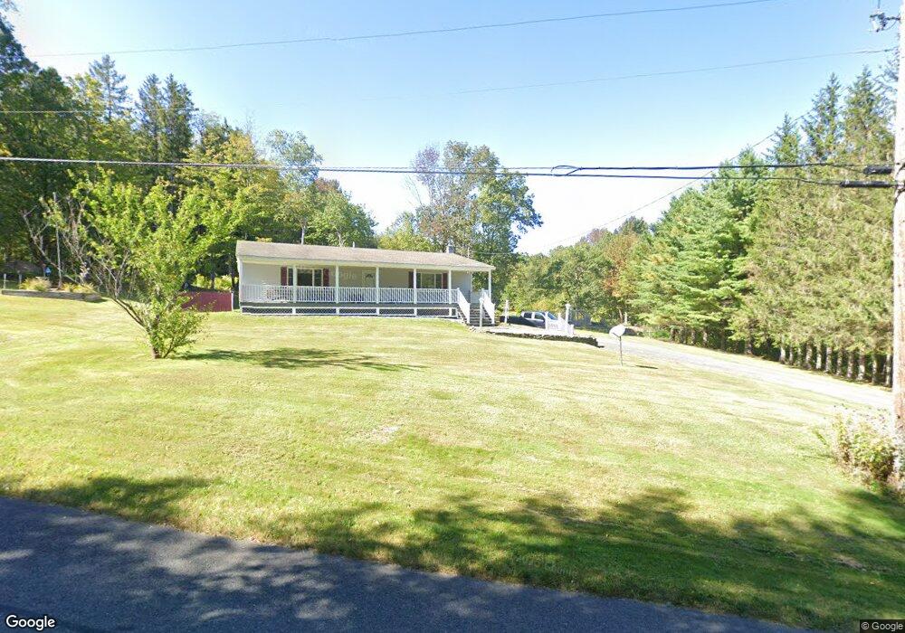
1 Monroe Rd Drury, MA 01343
Estimated Value: $244,000 - $306,781
2
Beds
2
Baths
1,200
Sq Ft
$222/Sq Ft
Est. Value
About This Home
This home is located at 1 Monroe Rd, Drury, MA 01343 and is currently estimated at $266,945, approximately $222 per square foot. 1 Monroe Rd is a home located in Berkshire County with nearby schools including Gabriel Abbott Memorial School.
Ownership History
Date
Name
Owned For
Owner Type
Purchase Details
Closed on
Jun 19, 2020
Sold by
Moriarty Patrick T
Bought by
White James R and White Pamela J
Current Estimated Value
Purchase Details
Closed on
Mar 12, 2010
Sold by
Schaffer Nancy A
Bought by
White James R and White Pamela J
Home Financials for this Owner
Home Financials are based on the most recent Mortgage that was taken out on this home.
Original Mortgage
$10,000
Interest Rate
5.02%
Mortgage Type
Purchase Money Mortgage
Purchase Details
Closed on
Oct 31, 2002
Sold by
Washington Mutual Bank
Bought by
White James R
Home Financials for this Owner
Home Financials are based on the most recent Mortgage that was taken out on this home.
Original Mortgage
$66,000
Interest Rate
6.09%
Mortgage Type
Purchase Money Mortgage
Purchase Details
Closed on
Mar 27, 2002
Sold by
Blair Douglas H and Blair Dina L
Bought by
Washington Mutual Bank
Purchase Details
Closed on
Apr 30, 1996
Sold by
Cilfone Joseph D and Dwyer Allen R
Bought by
Blair Douglas H
Home Financials for this Owner
Home Financials are based on the most recent Mortgage that was taken out on this home.
Original Mortgage
$78,900
Interest Rate
7.81%
Mortgage Type
Purchase Money Mortgage
Create a Home Valuation Report for This Property
The Home Valuation Report is an in-depth analysis detailing your home's value as well as a comparison with similar homes in the area
Home Values in the Area
Average Home Value in this Area
Purchase History
| Date | Buyer | Sale Price | Title Company |
|---|---|---|---|
| White James R | $30,000 | None Available | |
| White James R | -- | -- | |
| Schaffer Nancy A | -- | -- | |
| White James R | $78,500 | -- | |
| Washington Mutual Bank | $95,385 | -- | |
| Blair Douglas H | $78,900 | -- |
Source: Public Records
Mortgage History
| Date | Status | Borrower | Loan Amount |
|---|---|---|---|
| Previous Owner | Blair Douglas H | $60,000 | |
| Previous Owner | Schaffer Nancy A | $10,000 | |
| Previous Owner | Blair Douglas H | $66,000 | |
| Previous Owner | Blair Douglas H | $78,900 |
Source: Public Records
Tax History
| Year | Tax Paid | Tax Assessment Tax Assessment Total Assessment is a certain percentage of the fair market value that is determined by local assessors to be the total taxable value of land and additions on the property. | Land | Improvement |
|---|---|---|---|---|
| 2025 | $1,655 | $213,000 | $50,900 | $162,100 |
| 2023 | $1,489 | $176,000 | $43,200 | $132,800 |
| 2022 | $1,446 | $164,000 | $38,500 | $125,500 |
| 2021 | $1,385 | $162,700 | $37,200 | $125,500 |
| 2019 | $1,510 | $155,300 | $36,700 | $118,600 |
| 2018 | $1,614 | $155,300 | $36,700 | $118,600 |
| 2017 | $1,440 | $151,100 | $35,100 | $116,000 |
| 2016 | $1,408 | $151,100 | $35,100 | $116,000 |
| 2015 | $1,351 | $151,100 | $35,100 | $116,000 |
Source: Public Records
Map
Nearby Homes
- 214 Mohawk Trail
- 70 Mohawk Trail
- 140 Strykers Rd
- 0 Central Shaft Rd
- 0 Tunnel Rd
- 0 Strykers Rd
- 7 Poirot Rd
- 477 Mohawk Trail
- 0 Manley Phelps Rd Unit 246215
- 0 Oak Hill Unit 237953
- 0 Daniels Rd
- 350 Mohawk Trail
- 100 Autumn Dr
- 624 River Rd
- 87 North Rd
- 8 Thayer Rd
- 0 Beaver St
- 0 Mohawk Trail
- 77 Carson Ave
- 67 Carson Ave
Your Personal Tour Guide
Ask me questions while you tour the home.