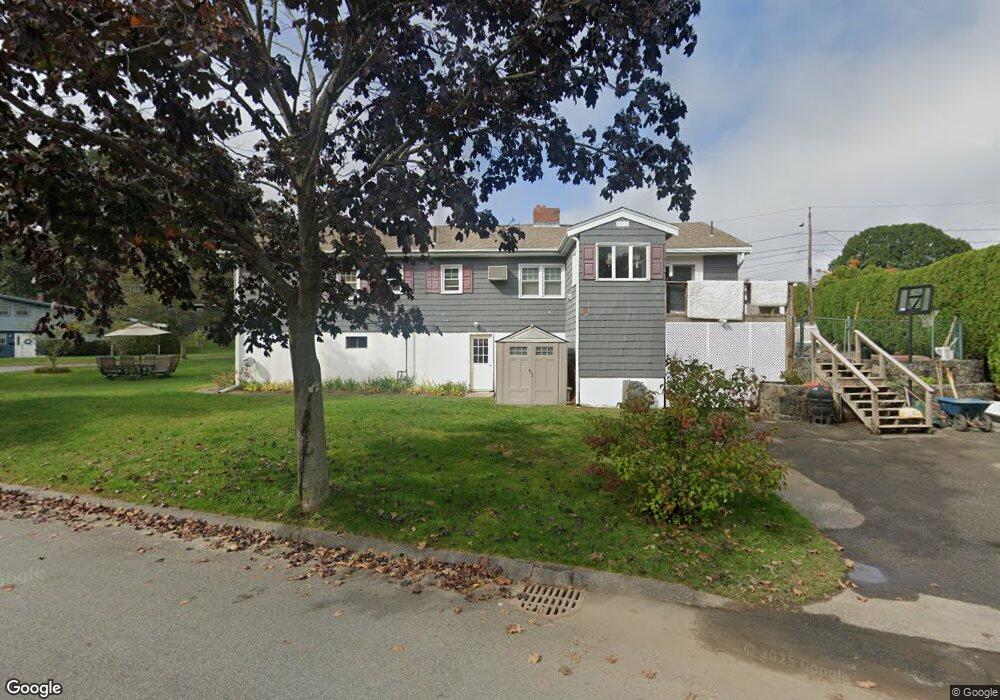
1 Morningside Dr Swampscott, MA 01907
Estimated Value: $745,101 - $898,000
3
Beds
2
Baths
1,883
Sq Ft
$435/Sq Ft
Est. Value
About This Home
This home is located at 1 Morningside Dr, Swampscott, MA 01907 and is currently estimated at $819,775, approximately $435 per square foot. 1 Morningside Dr is a home located in Essex County with nearby schools including Swampscott Middle School and Swampscott High School.
Ownership History
Date
Name
Owned For
Owner Type
Purchase Details
Closed on
Jul 7, 2000
Sold by
Katz Rita Est and Katz
Bought by
Legere Michael D and Legere Donna A
Current Estimated Value
Home Financials for this Owner
Home Financials are based on the most recent Mortgage that was taken out on this home.
Original Mortgage
$130,000
Outstanding Balance
$46,237
Interest Rate
8.55%
Mortgage Type
Purchase Money Mortgage
Estimated Equity
$773,538
Create a Home Valuation Report for This Property
The Home Valuation Report is an in-depth analysis detailing your home's value as well as a comparison with similar homes in the area
Home Values in the Area
Average Home Value in this Area
Purchase History
| Date | Buyer | Sale Price | Title Company |
|---|---|---|---|
| Legere Michael D | $275,000 | -- | |
| Legere Michael D | $275,000 | -- |
Source: Public Records
Mortgage History
| Date | Status | Borrower | Loan Amount |
|---|---|---|---|
| Open | Legere Michael D | $130,000 | |
| Closed | Legere Michael D | $130,000 |
Source: Public Records
Tax History
| Year | Tax Paid | Tax Assessment Tax Assessment Total Assessment is a certain percentage of the fair market value that is determined by local assessors to be the total taxable value of land and additions on the property. | Land | Improvement |
|---|---|---|---|---|
| 2025 | $7,207 | $628,300 | $349,700 | $278,600 |
| 2024 | $7,024 | $611,300 | $334,100 | $277,200 |
| 2023 | $6,829 | $581,700 | $313,200 | $268,500 |
| 2022 | $6,167 | $480,700 | $261,000 | $219,700 |
| 2021 | $6,003 | $435,000 | $234,900 | $200,100 |
| 2020 | $6,163 | $431,000 | $234,900 | $196,100 |
| 2019 | $6,234 | $410,100 | $214,000 | $196,100 |
| 2018 | $6,562 | $410,100 | $214,000 | $196,100 |
| 2017 | $6,462 | $370,300 | $187,900 | $182,400 |
| 2016 | $6,145 | $354,600 | $172,200 | $182,400 |
| 2015 | $6,081 | $354,600 | $172,200 | $182,400 |
| 2014 | $5,773 | $308,700 | $146,100 | $162,600 |
Source: Public Records
Map
Nearby Homes
- 3 Didio Dr
- 50 Mountwood Rd
- 51 Mountwood Rd
- 445 Essex St Unit 304
- 441 Essex St Unit 302
- 178 Norfolk Ave
- 64 Stetson Ave
- 46 Stetson Ave
- 71 Walnut Rd
- 1 Bond St
- 106 Norfolk Ave
- 1004 Paradise Rd Unit 1L
- 1002 Paradise Rd Unit PHE
- 80 Norfolk Ave Unit 1
- 49 Weatherly Dr
- 30 Weatherly Dr
- 11 Weatherly Dr
- 75 Bay View Dr
- 10 Arbutus Rd
- 49 Blaney St
- 2 Morningside Dr
- 1 Merrymount Dr
- 5 Plymouth Ln
- 4 Morningside Dr
- 4 Merrymount Dr
- 95 Plymouth Ave
- 3 Merrymount Dr
- 91 Plymouth Ave
- 11 Summit View Dr
- 68 Worcester Ave
- 10 Belleair Dr
- 9 Belleair Dr
- 11 Plymouth Ln
- 5 Morningside Dr
- 9 Summit View Dr
- 64 Worcester Ave Unit 1
- 64 Worcester Ave
- 64 Worcester Ave
- 64 Worcester Ave
- 5 Merrymount Dr
Your Personal Tour Guide
Ask me questions while you tour the home.