
1 Nostrand Rd Cranbury, NJ 08512
Estimated payment $10,835/month
Highlights
- In Ground Pool
- Sitting Area In Primary Bedroom
- Colonial Architecture
- Town Center Elementary School Rated A
- Dual Staircase
- Deck
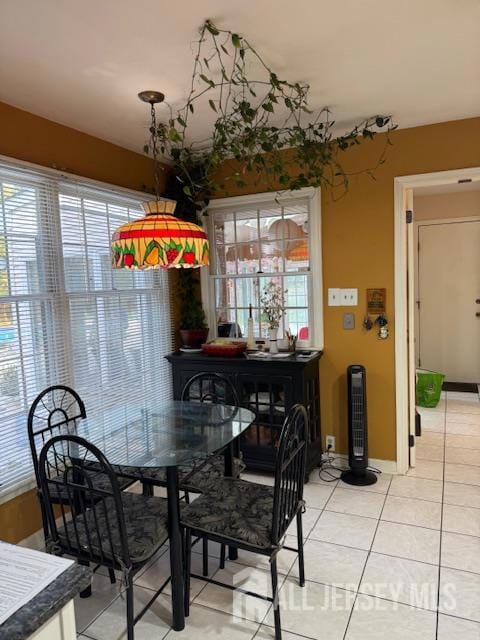
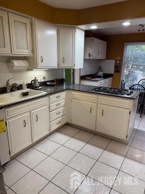
About This Home
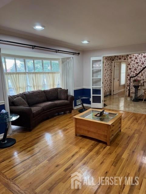
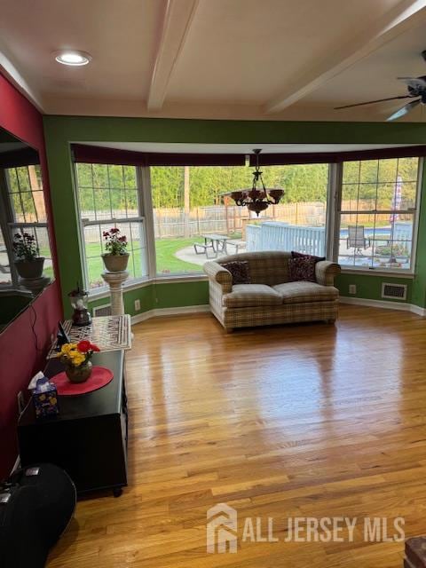
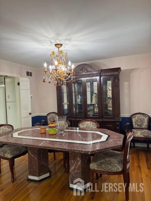
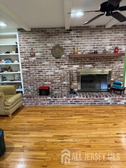
Beautiful corner lot in Plainsboro with stunning heated pool, large yard and an oversized patio. The charming home boasts hardwood flooring, custom molding and large, unique windows throughout. Recent upgrades have been made to bathrooms and pool. Brand new HVAC system, AC and hot water units have been installed. A grand, airy foyer welcomes you through French doors to the formal living room with a gas fireplace and dramatic floor-to-ceiling window, and a formal dining room large enough for your favorite holiday celebrations. Opposite the foyer, work and study in peace in a huge library and office with beautiful built-in bookshelves. A large bedroom with a powder room and full bath is also tucked away on this quieter side of the house for guests. The Tuscan-feel kitchen features granite countertops, ample cabinets, wood-paneled appliances and a dining nook that opens to a sun-drenched family room with cozy exposed brick with another gas fireplace and a door to the back deck. An understated side entrance leads to the mud room and laundry area with quick access to the basement, a heated sunroom that serves as a gateway to the backyard and pool, and another staircase to the 2nd floor bedrooms. A side-facing oversized garage completes the first floor. Upstairs, the owner's suite includes two luxurious bathrooms and two large closets. Three more generously sized rooms along with several closets and an additional full bathroom are widely spaced along the second level. The third is perfect as a play or office space to suit your needs as your family evolves. All bedrooms are rear- or side-facing for privacy and tranquility. This home is zoned to award-winning West Windsor-Plainsboro schools. Train station with express trains to NYC and Philadelphia and Princeton Medical Center are a quick drive. Here's your chance to own luxury real estate perfectly equipped for creating new memories with your family. Grab a book or board game from the library and curl up by a roaring fireplace. Host barbecues and soak in the hot tub while the kids perfect their cannonball. This home is not just a residence but a lifestyle choice, offering the very best of New Jersey living.
Home Details
Home Type
- Single Family
Est. Annual Taxes
- $23,559
Year Built
- Built in 1991
Lot Details
- 0.73 Acre Lot
- Lot Dimensions are 215.00 x 0.00
- Northeast Facing Home
- Fenced
- Corner Lot
- Wooded Lot
- Private Yard
- Property is zoned R150
Parking
- 3 Car Garage
- Garage Door Opener
- Circular Driveway
- Gravel Driveway
- Additional Parking
- On-Street Parking
- Open Parking
Home Design
- Colonial Architecture
- Asphalt Roof
Interior Spaces
- 4,348 Sq Ft Home
- 2-Story Property
- Dual Staircase
- Vaulted Ceiling
- Skylights
- 2 Fireplaces
- Gas Fireplace
- Blinds
- Great Room
- Family Room
- Formal Dining Room
- Library
- Attic
Kitchen
- Eat-In Kitchen
- Breakfast Bar
- Gas Oven or Range
- Self-Cleaning Oven
- Range
- Microwave
- Dishwasher
- Kitchen Island
- Granite Countertops
- Trash Compactor
Flooring
- Wood
- Marble
- Ceramic Tile
Bedrooms and Bathrooms
- 5 Bedrooms
- Sitting Area In Primary Bedroom
- Primary Bedroom on Main
- Cedar Closet
- Walk-In Closet
- Dressing Area
- Primary Bathroom is a Full Bathroom
- Dual Sinks
- Bathtub and Shower Combination in Primary Bathroom
- Soaking Tub
- Walk-in Shower
Laundry
- Laundry Room
- Dryer
- Washer
Basement
- Basement Fills Entire Space Under The House
- Basement Storage
- Natural lighting in basement
Home Security
- Intercom
- Storm Screens
Outdoor Features
- In Ground Pool
- Deck
- Enclosed Patio or Porch
Location
- Property is near public transit
- Property is near shops
Utilities
- Forced Air Heating and Cooling System
- Vented Exhaust Fan
- Water Filtration System
- Well
- Gas Water Heater
- Septic Tank
- Cable TV Available
Map
Home Values in the Area
Average Home Value in this Area
Tax History
| Year | Tax Paid | Tax Assessment Tax Assessment Total Assessment is a certain percentage of the fair market value that is determined by local assessors to be the total taxable value of land and additions on the property. | Land | Improvement |
|---|---|---|---|---|
| 2025 | $24,142 | $923,900 | $134,000 | $789,900 |
| 2024 | $23,559 | $923,900 | $134,000 | $789,900 |
| 2023 | $23,559 | $923,900 | $134,000 | $789,900 |
| 2022 | $23,199 | $923,900 | $134,000 | $789,900 |
| 2021 | $21,610 | $923,900 | $134,000 | $789,900 |
| 2020 | $22,100 | $923,900 | $134,000 | $789,900 |
| 2019 | $21,610 | $923,900 | $134,000 | $789,900 |
| 2018 | $21,130 | $923,900 | $134,000 | $789,900 |
| 2017 | $20,529 | $923,900 | $134,000 | $789,900 |
| 2016 | $19,624 | $923,900 | $134,000 | $789,900 |
| 2015 | $19,026 | $753,800 | $257,200 | $496,600 |
| 2014 | $18,837 | $753,800 | $257,200 | $496,600 |
Property History
| Date | Event | Price | List to Sale | Price per Sq Ft |
|---|---|---|---|---|
| 08/08/2025 08/08/25 | For Sale | $1,680,000 | -- | $386 / Sq Ft |
Purchase History
| Date | Type | Sale Price | Title Company |
|---|---|---|---|
| Deed | $525,000 | -- |
Mortgage History
| Date | Status | Loan Amount | Loan Type |
|---|---|---|---|
| Previous Owner | $322,700 | No Value Available |
Source: All Jersey MLS
MLS Number: 2602195R
APN: 18-03701-0000-00001
Disclaimer: Certain information contained herein is derived from information provided by parties other than Homes.com. All information provided is deemed reliable, but is not guaranteed to be accurate and should be independently verified.
![]() The data relating to real estate for sale on this web-site comes in part from the Internet Listing Display database of the CENTRAL JERSEY MULTIPLE LISTING SYSTEM, INC. Real estate listings held by brokerage firms other than this site-owner are marked with the ILD logo. The CENTRAL JERSEY MULTIPLE LISTING SYSTEM, INC does not warrant the accuracy, quality, reliability, suitability, completeness, usefulness or effectiveness of any information provided.
The data relating to real estate for sale on this web-site comes in part from the Internet Listing Display database of the CENTRAL JERSEY MULTIPLE LISTING SYSTEM, INC. Real estate listings held by brokerage firms other than this site-owner are marked with the ILD logo. The CENTRAL JERSEY MULTIPLE LISTING SYSTEM, INC does not warrant the accuracy, quality, reliability, suitability, completeness, usefulness or effectiveness of any information provided.
Copyright 2025, CENTRAL JERSEY MULTIPLE LISTING SYSTEM, INC All rights reserved
The CENTRAL JERSEY MULTIPLE LISTING SYSTEM, INC retains all rights, title and interest in and to its trademarks, service marks and copyrighted material.
The information being provided is for consumers' personal, non-commercial use and may not be used for any purpose other than to identify properties the consumer may be interested in purchasing or renting.
- 3 Beechtree Ln
- 95 Thoreau Dr
- 103 Tennyson Dr
- 7 Tennyson Dr
- 28 Ashford Dr
- 1216 Aspen Dr
- 7 Camas Ct
- 32 W Kincaid Dr
- 701 Aspen Dr
- 76 Ashford Dr
- 7703 Tamarron Dr
- 8408 Tamarron Dr
- 108 Aspen Dr Unit 108
- 11 Jay Ct
- 8508 Tamarron Dr
- 199 Hampshire Dr
- 60 Hampshire Dr
- 182 Hampshire Dr
- 100 Middlesex Blvd Unit 242
- 100 Middlesex Blvd Unit 211
- 153 Thoreau Dr
- 95 Thoreau Dr
- 151 Tennyson Dr
- 305 Deer Creek Dr
- 1020 Aspen Dr
- 1018 Aspen Dr Unit 1018
- 1217 Aspen Dr Unit 1217
- 914 Aspen Dr Unit 914
- 807 Aspen Dr
- 137 Hampshire Dr
- 620 Aspen Dr
- 1808 Aspen Dr
- 1914 Aspen Dr Unit 1914 Aspen Dr Plainaboro
- 2114 Aspen Dr
- 2015 Aspen Dr Unit 2015
- 304 Hampshire Dr
- 8402 Tamarron Dr
- 191 Hampshire Dr
- 211 Ravens Crest Dr
- 1000 Hunters Glen Dr
