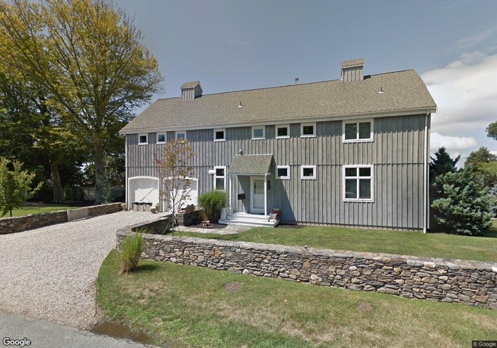
1 Odonnell Rd Middletown, RI 02842
Estimated Value: $1,468,000 - $2,089,000
2
Beds
4
Baths
2,392
Sq Ft
$778/Sq Ft
Est. Value
About This Home
This home is located at 1 Odonnell Rd, Middletown, RI 02842 and is currently estimated at $1,861,012, approximately $778 per square foot. 1 Odonnell Rd is a home located in Newport County with nearby schools including Middletown High School, St Michael's Country Day School, and St George's School.
Ownership History
Date
Name
Owned For
Owner Type
Purchase Details
Closed on
Jun 27, 2011
Sold by
Goldfarb Jason
Bought by
Goldfarb Jason and Gogg Nadine N
Current Estimated Value
Home Financials for this Owner
Home Financials are based on the most recent Mortgage that was taken out on this home.
Original Mortgage
$375,000
Interest Rate
4.63%
Create a Home Valuation Report for This Property
The Home Valuation Report is an in-depth analysis detailing your home's value as well as a comparison with similar homes in the area
Home Values in the Area
Average Home Value in this Area
Purchase History
| Date | Buyer | Sale Price | Title Company |
|---|---|---|---|
| Goldfarb Jason | -- | -- |
Source: Public Records
Mortgage History
| Date | Status | Borrower | Loan Amount |
|---|---|---|---|
| Open | Goldfarb Jason | $417,000 | |
| Closed | Goldfarb Jason | $94,000 | |
| Closed | Goldfarb Jason | $375,000 | |
| Previous Owner | Goldfarb Jason | $124,000 |
Source: Public Records
Tax History
| Year | Tax Paid | Tax Assessment Tax Assessment Total Assessment is a certain percentage of the fair market value that is determined by local assessors to be the total taxable value of land and additions on the property. | Land | Improvement |
|---|---|---|---|---|
| 2025 | $19,402 | $1,645,600 | $954,900 | $690,700 |
| 2024 | $18,529 | $1,645,600 | $954,900 | $690,700 |
| 2023 | $12,474 | $990,800 | $562,100 | $428,700 |
| 2022 | $11,482 | $955,200 | $562,100 | $393,100 |
| 2021 | $11,482 | $955,200 | $562,100 | $393,100 |
| 2020 | $11,129 | $808,800 | $470,000 | $338,800 |
| 2018 | $11,121 | $808,800 | $470,000 | $338,800 |
| 2016 | $8,166 | $529,600 | $223,300 | $306,300 |
| 2015 | $7,965 | $529,600 | $223,300 | $306,300 |
| 2014 | $8,098 | $503,900 | $203,100 | $300,800 |
| 2013 | $7,916 | $503,900 | $203,100 | $300,800 |
Source: Public Records
Map
Nearby Homes
- 11 Odonnell Rd
- 4 James St
- 140 Tuckerman Ave
- 0 Allston Ave
- 181 Center Ave
- 118 Wolcott Ave
- 206 Reservoir Rd
- 10 Oceanview Dr
- 141 Gray Craig Rd
- 129 Bliss Mine Rd
- 78 Ellery Rd
- 55 John Clarke Rd Unit 8
- 55 John Clarke Rd Unit 3
- 14 Kay Blvd
- 5 Dresser St
- 198 Gibbs Ave
- 476 Green End Ave
- 1 Oakwood Terrace Unit 7
- 10 Ocean Lawn Ln
- 4 Red Cross Ave Unit 4
- 398 Wolcott Ave Unit 9
- 398 Wolcott Ave Unit 2
- 398 Wolcott Ave Unit 5
- 398 Wolcott Ave Unit 4
- 398 Wolcott Ave Unit 7
- 398 Wolcott Ave Unit 3
- 398 Wolcott Ave Unit 8
- 398 Wolcott Ave Unit 6
- 398 Wolcott Ave
- 5 O’donnell Rd
- 313 Purgatory Rd
- 5 O'Donnell Rd
- 5 Odonnell Rd
- 5 Odonnell Rd
- 0 O'Donnell Rd Unit 539925
- 0 O'Donnell Rd Unit 995120
- 2 O'Donnell Rd
- 2 Odonnell Rd
- 412 Wolcott Ave
- 4 O'Donnell Rd
Your Personal Tour Guide
Ask me questions while you tour the home.