Estimated Value: $778,135 - $951,000
4
Beds
3
Baths
1,792
Sq Ft
$470/Sq Ft
Est. Value
About This Home
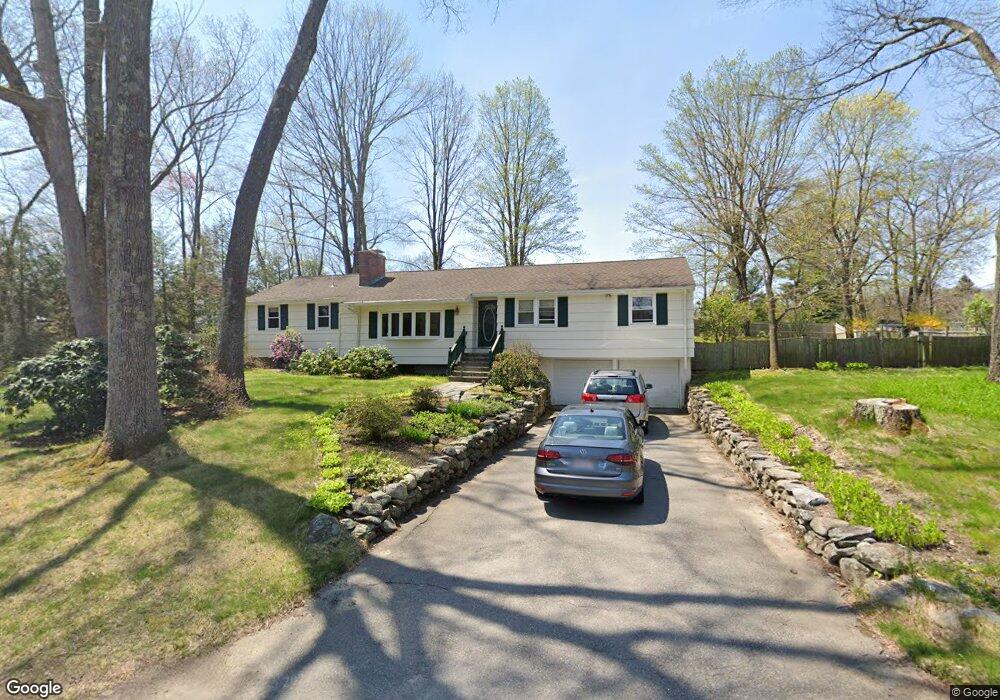
This home is located at 1 Pinewood Rd, Acton, MA 01720 and is currently estimated at $842,534, approximately $470 per square foot. 1 Pinewood Rd is a home located in Middlesex County with nearby schools including Acton-Boxborough Regional High School, Maynard Knowledge Beginnings, and The Imago School.
Ownership History
Date
Name
Owned For
Owner Type
Purchase Details
Closed on
Aug 22, 2003
Sold by
Slowick Elizabeth M
Bought by
Beldiya Elena and Petrov Sergi O
Current Estimated Value
Home Financials for this Owner
Home Financials are based on the most recent Mortgage that was taken out on this home.
Original Mortgage
$322,700
Interest Rate
5.52%
Mortgage Type
Purchase Money Mortgage
Purchase Details
Closed on
Oct 7, 1993
Sold by
Landheim Gregory K
Bought by
Slowick Elizabeth M
Home Financials for this Owner
Home Financials are based on the most recent Mortgage that was taken out on this home.
Original Mortgage
$181,400
Interest Rate
6.9%
Mortgage Type
Purchase Money Mortgage
Purchase Details
Closed on
May 11, 1990
Sold by
Thompson David M
Bought by
Landheim Gregory K
Create a Home Valuation Report for This Property
The Home Valuation Report is an in-depth analysis detailing your home's value as well as a comparison with similar homes in the area
Home Values in the Area
Average Home Value in this Area
Purchase History
| Date | Buyer | Sale Price | Title Company |
|---|---|---|---|
| Beldiya Elena | $439,000 | -- | |
| Slowick Elizabeth M | $110,187 | -- | |
| Landheim Gregory K | $225,800 | -- |
Source: Public Records
Mortgage History
| Date | Status | Borrower | Loan Amount |
|---|---|---|---|
| Open | Landheim Gregory K | $284,000 | |
| Closed | Landheim Gregory K | $294,000 | |
| Closed | Beldiya Elena | $322,700 | |
| Previous Owner | Landheim Gregory K | $228,000 | |
| Previous Owner | Landheim Gregory K | $181,400 |
Source: Public Records
Tax History Compared to Growth
Tax History
| Year | Tax Paid | Tax Assessment Tax Assessment Total Assessment is a certain percentage of the fair market value that is determined by local assessors to be the total taxable value of land and additions on the property. | Land | Improvement |
|---|---|---|---|---|
| 2025 | $11,436 | $666,800 | $315,200 | $351,600 |
| 2024 | $11,062 | $663,600 | $315,200 | $348,400 |
| 2023 | $10,562 | $601,500 | $286,600 | $314,900 |
| 2022 | $10,532 | $541,500 | $248,900 | $292,600 |
| 2021 | $10,056 | $497,100 | $230,500 | $266,600 |
| 2020 | $9,574 | $497,600 | $230,500 | $267,100 |
| 2019 | $9,083 | $468,900 | $230,500 | $238,400 |
| 2018 | $8,424 | $434,700 | $230,500 | $204,200 |
| 2017 | $8,285 | $434,700 | $230,500 | $204,200 |
| 2016 | $7,775 | $404,300 | $230,500 | $173,800 |
| 2015 | $7,618 | $399,900 | $230,500 | $169,400 |
| 2014 | $7,729 | $397,400 | $230,500 | $166,900 |
Source: Public Records
Map
Nearby Homes
- 70 River St
- 7 Kelley Rd
- 46 Taylor Rd
- 27 Forest Rd
- 246 Main St Unit 2
- 129 Main St Unit 129
- 131 Main St
- 40 High St
- 19 Railroad St Unit D2
- 19 Railroad St Unit C2
- 11 Braebrook
- 128 Parker St Unit 3B
- 132 Parker St Unit G5
- 3 Drummer Rd Unit B3
- 7 Concetta Cir
- 491 Main St
- 60 Lawsbrook Rd
- 79 Charter Rd
- 4,7,8 Crestwood Ln
- 33 Meadowbrook Rd