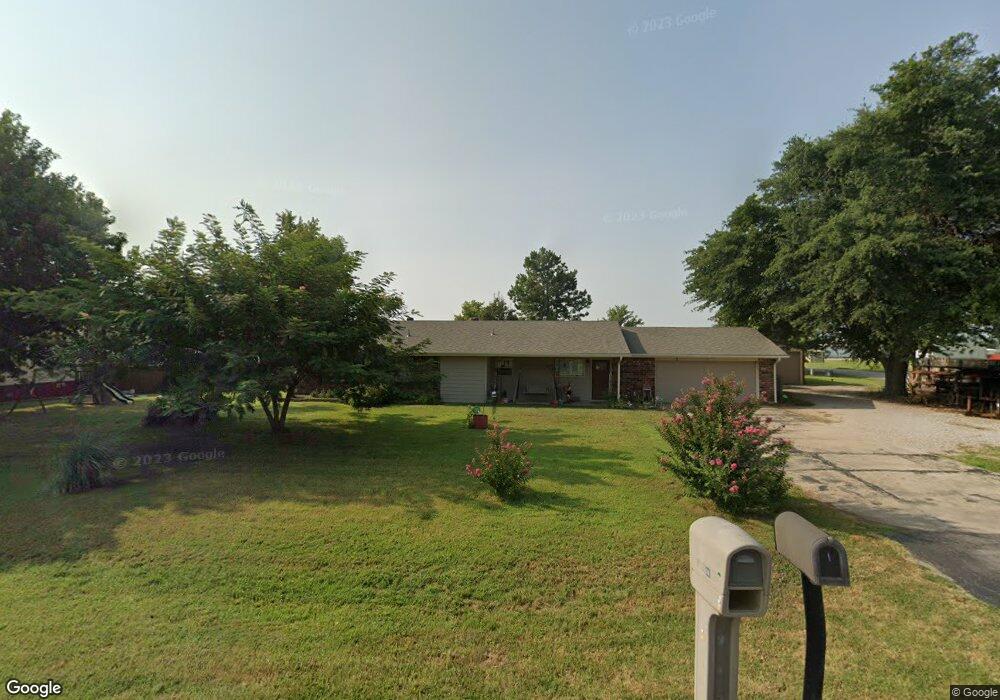
1 Robin Rd Shawnee, OK 74804
Estimated Value: $207,465 - $239,000
3
Beds
2
Baths
1,470
Sq Ft
$152/Sq Ft
Est. Value
About This Home
This home is located at 1 Robin Rd, Shawnee, OK 74804 and is currently estimated at $223,616, approximately $152 per square foot. 1 Robin Rd is a home located in Pottawatomie County with nearby schools including Dale Elementary School, Dale Middle School, and Dale High School.
Ownership History
Date
Name
Owned For
Owner Type
Purchase Details
Closed on
Jun 25, 2009
Sold by
Bryan Betty Lou and The Betty Lou Bryan 1998 Revoc
Bought by
Stone Victor Odell
Current Estimated Value
Home Financials for this Owner
Home Financials are based on the most recent Mortgage that was taken out on this home.
Original Mortgage
$127,500
Outstanding Balance
$80,167
Interest Rate
4.84%
Mortgage Type
Purchase Money Mortgage
Estimated Equity
$143,449
Create a Home Valuation Report for This Property
The Home Valuation Report is an in-depth analysis detailing your home's value as well as a comparison with similar homes in the area
Purchase History
| Date | Buyer | Sale Price | Title Company |
|---|---|---|---|
| Stone Victor Odell | $125,000 | None Available |
Source: Public Records
Mortgage History
| Date | Status | Borrower | Loan Amount |
|---|---|---|---|
| Open | Stone Victor Odell | $127,500 |
Source: Public Records
Tax History
| Year | Tax Paid | Tax Assessment Tax Assessment Total Assessment is a certain percentage of the fair market value that is determined by local assessors to be the total taxable value of land and additions on the property. | Land | Improvement |
|---|---|---|---|---|
| 2025 | $1,685 | $16,914 | $1,800 | $15,114 |
| 2024 | $1,748 | $16,422 | $1,800 | $14,622 |
| 2023 | $1,748 | $16,422 | $1,800 | $14,622 |
| 2022 | $1,584 | $16,422 | $1,800 | $14,622 |
| 2021 | $1,738 | $16,422 | $1,800 | $14,622 |
| 2020 | $1,832 | $17,257 | $1,800 | $15,457 |
| 2019 | $1,441 | $13,316 | $1,800 | $11,516 |
| 2018 | $1,465 | $13,656 | $1,800 | $11,856 |
| 2017 | $1,392 | $13,458 | $1,800 | $11,658 |
| 2016 | $1,180 | $13,065 | $1,800 | $11,265 |
| 2015 | $1,178 | $12,686 | $1,800 | $10,886 |
| 2014 | $1,178 | $12,937 | $1,800 | $11,137 |
Source: Public Records
Map
Nearby Homes
- 8 Clark Cir
- 37802 W Old Highway 270
- 36601 W 45th St
- 10667 N Kickapoo Ave
- 2700 Woodlawn Ct
- 2715 Woodlawn Ct
- 2727 Woodlawn Ct
- 38172 W 45th St
- 0 Gaddy Rd Unit OKC1215621
- 13804 Coker Rd
- 27 Willowbrook
- 129 Lake Shore Dr
- 121 Lake Shore Dr
- 36236 Prairie Ridge Ct
- 0 Coker Rd
- 36021 Prairie Rdg Rd
- 36506 Garretts Lake Rd
- 37614 W Macarthur St
- 35502 Pecan Grove Rd
- 36656 Garrett's Lake Rd
Your Personal Tour Guide
Ask me questions while you tour the home.