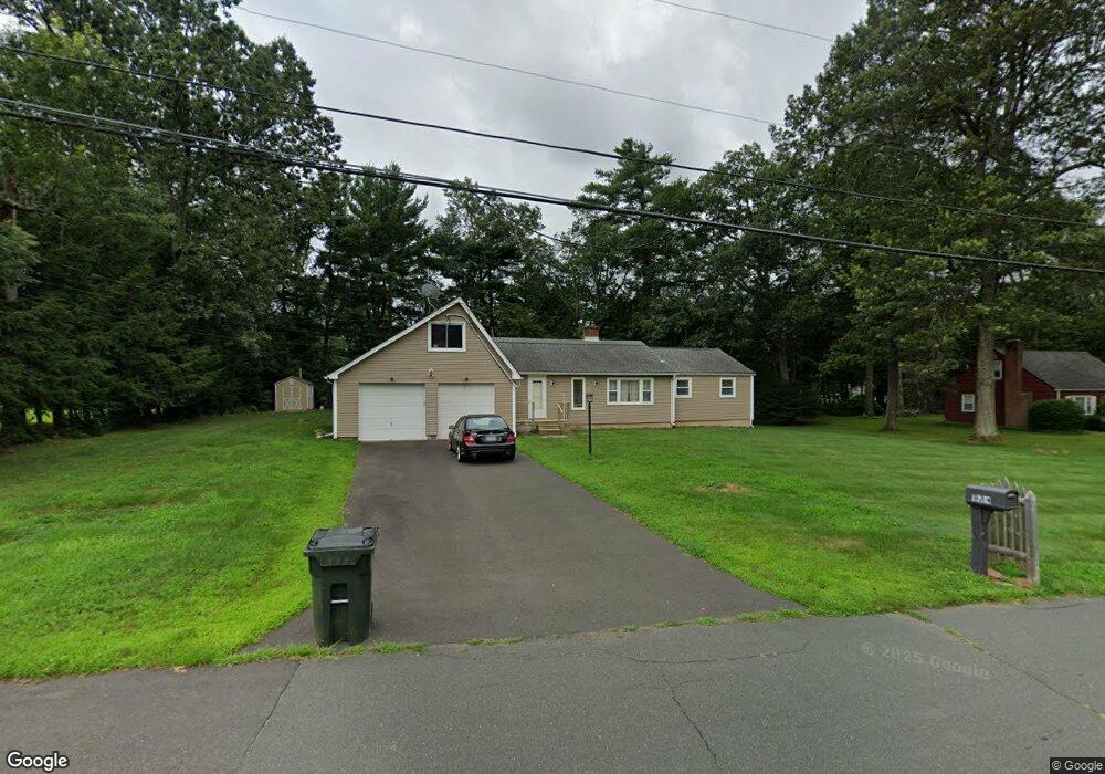
1 Robin Rd Simsbury, CT 06070
Estimated Value: $387,000 - $423,000
3
Beds
1
Bath
1,420
Sq Ft
$285/Sq Ft
Est. Value
About This Home
This home is located at 1 Robin Rd, Simsbury, CT 06070 and is currently estimated at $404,048, approximately $284 per square foot. 1 Robin Rd is a home located in Hartford County with nearby schools including Squadron Line School, Henry James Memorial School, and Simsbury High School.
Ownership History
Date
Name
Owned For
Owner Type
Purchase Details
Closed on
Jan 16, 2003
Sold by
Paine Michael R and Paine Jean V
Bought by
Kohler Daniel B
Current Estimated Value
Purchase Details
Closed on
Nov 19, 1996
Sold by
Waite Mary V
Bought by
Hatten Charles T
Purchase Details
Closed on
Oct 4, 1994
Sold by
Dornfried Robert B
Bought by
Lewandowski Mark D and Lewandowski Nancy M
Create a Home Valuation Report for This Property
The Home Valuation Report is an in-depth analysis detailing your home's value as well as a comparison with similar homes in the area
Home Values in the Area
Average Home Value in this Area
Purchase History
| Date | Buyer | Sale Price | Title Company |
|---|---|---|---|
| Kohler Daniel B | $170,000 | -- | |
| Hatten Charles T | $181,000 | -- | |
| Lewandowski Mark D | $107,000 | -- |
Source: Public Records
Mortgage History
| Date | Status | Borrower | Loan Amount |
|---|---|---|---|
| Open | Lewandowski Mark D | $202,785 | |
| Closed | Lewandowski Mark D | $217,745 |
Source: Public Records
Tax History
| Year | Tax Paid | Tax Assessment Tax Assessment Total Assessment is a certain percentage of the fair market value that is determined by local assessors to be the total taxable value of land and additions on the property. | Land | Improvement |
|---|---|---|---|---|
| 2025 | $6,578 | $192,570 | $72,800 | $119,770 |
| 2024 | $6,415 | $192,570 | $72,800 | $119,770 |
| 2023 | $6,128 | $192,570 | $72,800 | $119,770 |
| 2022 | $5,845 | $151,310 | $76,440 | $74,870 |
| 2021 | $5,845 | $151,310 | $76,440 | $74,870 |
| 2020 | $5,612 | $151,310 | $76,440 | $74,870 |
| 2019 | $5,647 | $151,310 | $76,440 | $74,870 |
| 2018 | $5,688 | $151,310 | $76,440 | $74,870 |
| 2017 | $5,520 | $142,420 | $76,440 | $65,980 |
| 2016 | $5,287 | $142,420 | $76,440 | $65,980 |
| 2015 | $5,287 | $142,420 | $76,440 | $65,980 |
| 2014 | $5,289 | $142,420 | $76,440 | $65,980 |
Source: Public Records
Map
Nearby Homes
- 7 Grimes Brook Place
- 2 Lionel Dr
- 31 Oxford Ct
- 9 1/2 E Tomstead Rd
- 21 North Dr
- 10 Massaco St Unit G
- 42 Holcomb St
- 40 Firetown Rd Unit 22
- 59 Cambridge Ct
- 42 Library Ln Unit 42
- 1 West St Unit 112
- 324 Old Farms Rd
- 30 Southbridge Ct Unit 30
- 14 Brettonwood Dr
- 48 Whitman Dr
- 2 Gillette Ct Unit D
- 24 Hunting Ridge Dr
- 32 Hemlock Rd
- 2 Meadow Ct
- 10 Pasture Ln
- 54 Chriswell Dr
- 5 Robin Rd
- 27 Grimes Ln
- 51 Chriswell Dr
- 48 Chriswell Dr
- 21 Grimes Ln
- 29 Grimes Brook Place
- 7 Robin Rd
- 19 Grimes Ln
- 56 Chriswell Dr
- 4 Robin Rd
- 45 Chriswell Dr
- 44 Chriswell Dr
- 17 Grimes Brook Place
- 57 Chriswell Dr
- 31 Grimes Brook Place
- 24 Grimes Brook Place
- 43 Chriswell Dr
- 6 Robin Rd
- 33 Grimes Brook Place
Your Personal Tour Guide
Ask me questions while you tour the home.