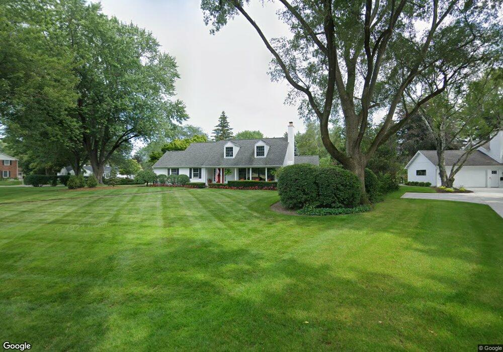
1 Rust Ln Saginaw, MI 48602
Estimated Value: $306,629 - $526,000
3
Beds
3
Baths
2,408
Sq Ft
$165/Sq Ft
Est. Value
About This Home
This home is located at 1 Rust Ln, Saginaw, MI 48602 and is currently estimated at $396,407, approximately $164 per square foot. 1 Rust Ln is a home located in Saginaw County with nearby schools including Westdale Elementary School, Arrowwood Elementary School, and White Pine Middle School.
Ownership History
Date
Name
Owned For
Owner Type
Purchase Details
Closed on
Sep 16, 2011
Sold by
Braun William A and Braun Bonnie Sue
Bought by
Burris And Katherine Smith Trust
Current Estimated Value
Home Financials for this Owner
Home Financials are based on the most recent Mortgage that was taken out on this home.
Original Mortgage
$149,000
Outstanding Balance
$13,203
Interest Rate
4.32%
Mortgage Type
Purchase Money Mortgage
Estimated Equity
$383,204
Create a Home Valuation Report for This Property
The Home Valuation Report is an in-depth analysis detailing your home's value as well as a comparison with similar homes in the area
Home Values in the Area
Average Home Value in this Area
Purchase History
| Date | Buyer | Sale Price | Title Company |
|---|---|---|---|
| Burris And Katherine Smith Trust | $249,000 | -- |
Source: Public Records
Mortgage History
| Date | Status | Borrower | Loan Amount |
|---|---|---|---|
| Open | Burris And Katherine Smith Trust | $149,000 |
Source: Public Records
Tax History
| Year | Tax Paid | Tax Assessment Tax Assessment Total Assessment is a certain percentage of the fair market value that is determined by local assessors to be the total taxable value of land and additions on the property. | Land | Improvement |
|---|---|---|---|---|
| 2025 | $2,724 | $128,200 | $0 | $0 |
| 2024 | $2,923 | $137,600 | $0 | $0 |
| 2023 | $2,798 | $131,800 | $0 | $0 |
| 2022 | $4,892 | $130,500 | $0 | $0 |
| 2021 | $4,503 | $125,600 | $0 | $0 |
| 2020 | $4,660 | $129,300 | $0 | $0 |
| 2019 | $4,523 | $131,000 | $27,300 | $103,700 |
| 2018 | $2,398 | $133,500 | $0 | $0 |
| 2017 | $4,122 | $133,400 | $0 | $0 |
| 2016 | $4,084 | $132,400 | $0 | $0 |
| 2014 | $4,034 | $139,200 | $0 | $106,200 |
| 2013 | -- | $131,300 | $0 | $0 |
Source: Public Records
Map
Nearby Homes
- 79 Davis Dr
- 27 W Hannum Blvd
- 21 W Hannum Blvd
- 4135 Green St
- 0 Gratiot Ave
- 60 Golfview Dr
- 2002 Marquette St
- 516 S Wheeler St
- 900 Stoneham Rd
- 210 Golfview Dr
- 310 S Wheeler St
- 203 Ardussi Ave
- 1416 Andrew St
- 2116 Wood St
- 202 S Wheeler St
- 359 Holbrook Ln
- 1306 S Wheeler St
- 1946 Gratiot Ave
- 16 Southlawn Ct
- 1450 Timothy St
Your Personal Tour Guide
Ask me questions while you tour the home.