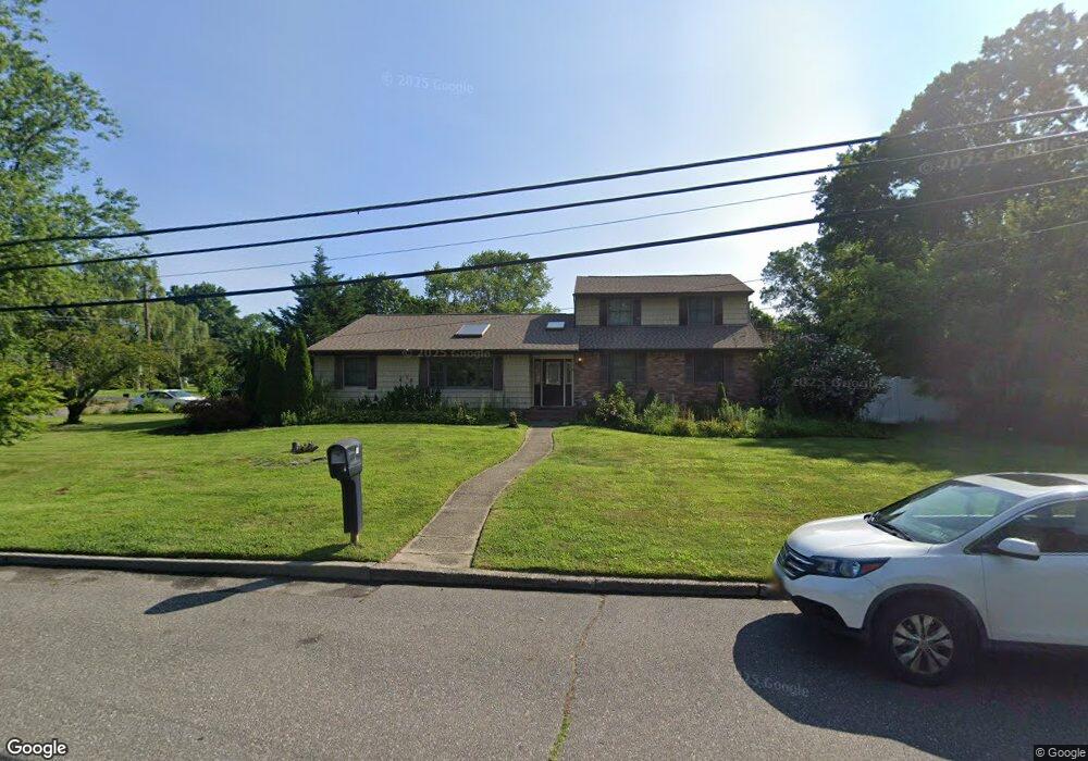
1 Sage Rd Port Jefferson Station, NY 11776
Estimated Value: $608,000 - $920,427
5
Beds
3
Baths
2,724
Sq Ft
$264/Sq Ft
Est. Value
About This Home
This home is located at 1 Sage Rd, Port Jefferson Station, NY 11776 and is currently estimated at $719,857, approximately $264 per square foot. 1 Sage Rd is a home located in Suffolk County with nearby schools including John F Kennedy Middle School and Comsewogue High School.
Ownership History
Date
Name
Owned For
Owner Type
Purchase Details
Closed on
Sep 28, 2004
Sold by
Glicksman Eugene H
Bought by
Flores Luis
Current Estimated Value
Purchase Details
Closed on
Apr 10, 2001
Sold by
Barrack Robin
Bought by
Glicksman Eugene H
Home Financials for this Owner
Home Financials are based on the most recent Mortgage that was taken out on this home.
Original Mortgage
$240,000
Interest Rate
6.9%
Mortgage Type
Purchase Money Mortgage
Purchase Details
Closed on
Dec 30, 1996
Sold by
Barrack Robin and Herman Candace
Bought by
Barrack Robin
Purchase Details
Closed on
Sep 1, 1994
Sold by
Barrack Robin
Bought by
Barrack Robin and Herman Candace
Create a Home Valuation Report for This Property
The Home Valuation Report is an in-depth analysis detailing your home's value as well as a comparison with similar homes in the area
Home Values in the Area
Average Home Value in this Area
Purchase History
| Date | Buyer | Sale Price | Title Company |
|---|---|---|---|
| Flores Luis | $310,000 | Martin Silver | |
| Glicksman Eugene H | $300,000 | Omni Title | |
| Barrack Robin | -- | First American Title Ins Co | |
| Barrack Robin | -- | First American Title Ins Co |
Source: Public Records
Mortgage History
| Date | Status | Borrower | Loan Amount |
|---|---|---|---|
| Previous Owner | Glicksman Eugene H | $240,000 |
Source: Public Records
Tax History Compared to Growth
Tax History
| Year | Tax Paid | Tax Assessment Tax Assessment Total Assessment is a certain percentage of the fair market value that is determined by local assessors to be the total taxable value of land and additions on the property. | Land | Improvement |
|---|---|---|---|---|
| 2024 | $11,704 | $2,945 | $325 | $2,620 |
| 2023 | $11,704 | $2,945 | $325 | $2,620 |
| 2022 | $10,330 | $2,945 | $325 | $2,620 |
| 2021 | $10,330 | $2,945 | $325 | $2,620 |
| 2020 | $10,588 | $2,945 | $325 | $2,620 |
| 2019 | $10,588 | $0 | $0 | $0 |
| 2018 | $10,085 | $2,945 | $325 | $2,620 |
| 2017 | $10,085 | $2,945 | $325 | $2,620 |
| 2016 | $9,998 | $2,945 | $325 | $2,620 |
| 2015 | -- | $2,945 | $325 | $2,620 |
| 2014 | -- | $2,945 | $325 | $2,620 |
Source: Public Records
Map
Nearby Homes
- 24 Kennedy Rd
- 4 Linda St
- 4 Forest Ave
- 203 Sterling St
- 26 Forest Ave
- 37 Deer Ln
- 22 Washington Ave
- 30 Bunny Ln
- 105 Commodore Cir
- 148 Captains Way
- 29 Erin Ln
- 34 Thomas Ln
- 35 Woodchuck Ln
- 460 Old Town Rd Unit 7G
- 460 Old Town Rd Unit 24E
- 460 Old Town Rd Unit 7K
- 460 Old Town Rd Unit 8H
- 460 Old Town Rd Unit 25L Upper Unit
- 460 Old Town Rd Unit 26P
- 460 Old Town Rd Unit 25M