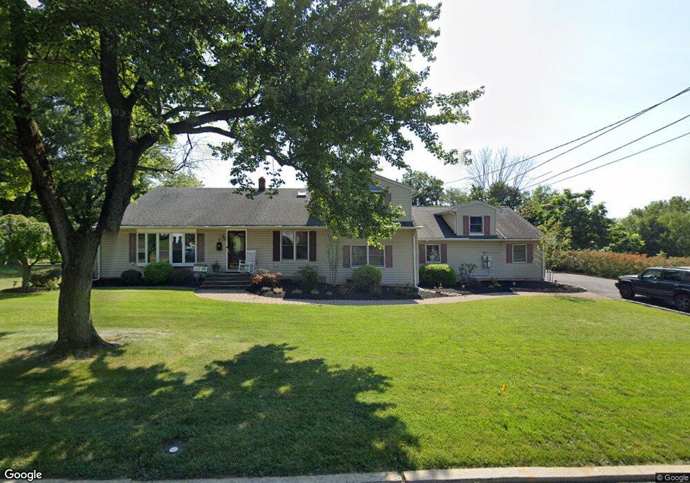
1 Shady Ln Bound Brook, NJ 08805
Estimated Value: $662,000 - $765,000
--
Bed
--
Bath
2,880
Sq Ft
$251/Sq Ft
Est. Value
About This Home
This home is located at 1 Shady Ln, Bound Brook, NJ 08805 and is currently estimated at $723,310, approximately $251 per square foot. 1 Shady Ln is a home located in Somerset County with nearby schools including Adamsville Primary School, Bridgewater-Raritan Middle School, and Hillside Intermediate School.
Ownership History
Date
Name
Owned For
Owner Type
Purchase Details
Closed on
May 17, 2004
Sold by
Maszczak Joseph
Bought by
Oram Thomas M and Oram Alison
Current Estimated Value
Home Financials for this Owner
Home Financials are based on the most recent Mortgage that was taken out on this home.
Original Mortgage
$284,000
Outstanding Balance
$138,935
Interest Rate
6.12%
Estimated Equity
$584,375
Create a Home Valuation Report for This Property
The Home Valuation Report is an in-depth analysis detailing your home's value as well as a comparison with similar homes in the area
Home Values in the Area
Average Home Value in this Area
Purchase History
| Date | Buyer | Sale Price | Title Company |
|---|---|---|---|
| Oram Thomas M | $355,000 | -- |
Source: Public Records
Mortgage History
| Date | Status | Borrower | Loan Amount |
|---|---|---|---|
| Open | Oram Thomas M | $284,000 |
Source: Public Records
Tax History Compared to Growth
Tax History
| Year | Tax Paid | Tax Assessment Tax Assessment Total Assessment is a certain percentage of the fair market value that is determined by local assessors to be the total taxable value of land and additions on the property. | Land | Improvement |
|---|---|---|---|---|
| 2025 | $11,233 | $577,900 | $231,500 | $346,400 |
| 2024 | $11,233 | $569,900 | $231,500 | $338,400 |
| 2023 | $10,065 | $501,500 | $231,500 | $270,000 |
| 2022 | $9,583 | $459,400 | $226,500 | $232,900 |
| 2021 | $8,794 | $446,100 | $226,500 | $219,600 |
| 2020 | $8,791 | $413,100 | $226,500 | $186,600 |
| 2019 | $8,794 | $409,200 | $226,500 | $182,700 |
| 2018 | $8,675 | $404,600 | $226,500 | $178,100 |
| 2017 | $8,436 | $393,100 | $226,500 | $166,600 |
| 2016 | $8,301 | $392,500 | $226,500 | $166,000 |
| 2015 | $8,230 | $389,500 | $226,500 | $163,000 |
| 2014 | $7,967 | $371,400 | $226,500 | $144,900 |
Source: Public Records
Map
Nearby Homes
- 143 Vosseller Ave
- 1740 Middlebrook Rd
- 617 Vosseller Ave
- 606 Vosseller Ave
- 601 Thompson Ave
- 745 Schoolhouse Ln
- 641 Crescent Dr
- 563 Winsor St
- 301 Stratford Place
- 307 W Union Ave
- 180 Farm Ln
- 722 Lawrence Rd
- 504 Stratford Place
- 650 Central Ave
- 520 Winsor St
- 1820 Woodland Terrace
- 102 W Franklin St
- 14 E Maple Ave
- 807 Watchung Rd
- 130 W High St Unit 132