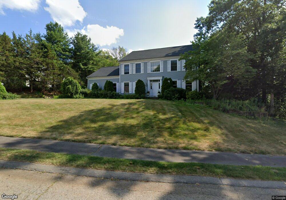
1 Skowhegan Way Natick, MA 01760
Estimated Value: $1,436,000 - $1,620,000
4
Beds
3
Baths
3,238
Sq Ft
$462/Sq Ft
Est. Value
About This Home
This home is located at 1 Skowhegan Way, Natick, MA 01760 and is currently estimated at $1,496,705, approximately $462 per square foot. 1 Skowhegan Way is a home located in Middlesex County with nearby schools including Natick High School, Lilja Elementary School, and Wilson Middle School.
Ownership History
Date
Name
Owned For
Owner Type
Purchase Details
Closed on
Jan 8, 2024
Sold by
Metzgar Elizabeth
Bought by
Elizabeth Metzgar 2024 T and Elizabeth Metzgar
Current Estimated Value
Purchase Details
Closed on
Jan 23, 2019
Sold by
Metzgar Elizabeth A and Metzgar Jeffrey A
Bought by
Metzgar Elizabeth
Home Financials for this Owner
Home Financials are based on the most recent Mortgage that was taken out on this home.
Original Mortgage
$313,600
Interest Rate
4.5%
Mortgage Type
Adjustable Rate Mortgage/ARM
Create a Home Valuation Report for This Property
The Home Valuation Report is an in-depth analysis detailing your home's value as well as a comparison with similar homes in the area
Home Values in the Area
Average Home Value in this Area
Purchase History
| Date | Buyer | Sale Price | Title Company |
|---|---|---|---|
| Elizabeth Metzgar 2024 T | -- | None Available | |
| Metzgar Elizabeth | -- | -- |
Source: Public Records
Mortgage History
| Date | Status | Borrower | Loan Amount |
|---|---|---|---|
| Previous Owner | Metzgar Elizabeth | $313,600 |
Source: Public Records
Tax History Compared to Growth
Tax History
| Year | Tax Paid | Tax Assessment Tax Assessment Total Assessment is a certain percentage of the fair market value that is determined by local assessors to be the total taxable value of land and additions on the property. | Land | Improvement |
|---|---|---|---|---|
| 2025 | $14,281 | $1,194,100 | $500,600 | $693,500 |
| 2024 | $13,877 | $1,131,900 | $474,200 | $657,700 |
| 2023 | $12,750 | $1,008,700 | $440,400 | $568,300 |
| 2022 | $12,600 | $944,500 | $396,400 | $548,100 |
| 2021 | $12,237 | $899,100 | $391,200 | $507,900 |
| 2020 | $12,023 | $883,400 | $375,500 | $507,900 |
| 2019 | $11,228 | $883,400 | $375,500 | $507,900 |
| 2018 | $10,625 | $814,200 | $362,500 | $451,700 |
| 2017 | $10,865 | $805,400 | $361,900 | $443,500 |
| 2016 | $10,871 | $801,100 | $361,900 | $439,200 |
| 2015 | $10,505 | $760,100 | $361,900 | $398,200 |
Source: Public Records
Map
Nearby Homes
- 15 Penobscot Rd
- 20 Marion St
- 18 University Dr
- 67 E Central St & 5 Union St
- 31 Marion St
- 191 E Central St
- 10 Sundance Way
- 62 E Central St Unit 305
- 11 Avon St
- 3 Vale St Unit B
- 5 Wilson St Unit 5A
- 3 Wilson St Unit 3B
- 6B Lincoln St Unit 6B
- 4B Lincoln St Unit 4B
- 9 Arbor Cir
- 94 Woodland St
- 15 Church St Unit 3
- 25 Sawin St
- 39 Davis Brook Dr
- 192 Pond Rd
- 3 Skowhegan Way
- 6 Skowhegan Way
- 2 Skowhegan Way
- 6 Skowhegan Way
- 5 Skowhegan Way
- 4 Skowhegan Way
- 1 Woronoco Dr Unit A
- 8 Skowhegan Way
- 10 Skowhegan Way
- 7 Skowhegan Way
- 12 Skowhegan Way
- 1 Penobscot Rd
- 3 Woronoco Dr
- 8 Penobscot Rd
- 5 Woronoco Dr
- 11 Woronoco Dr
- 14 Skowhegan Way
- 3 Penobscot Rd
- 9 Woronoco Dr
- 10 Penobscot Rd