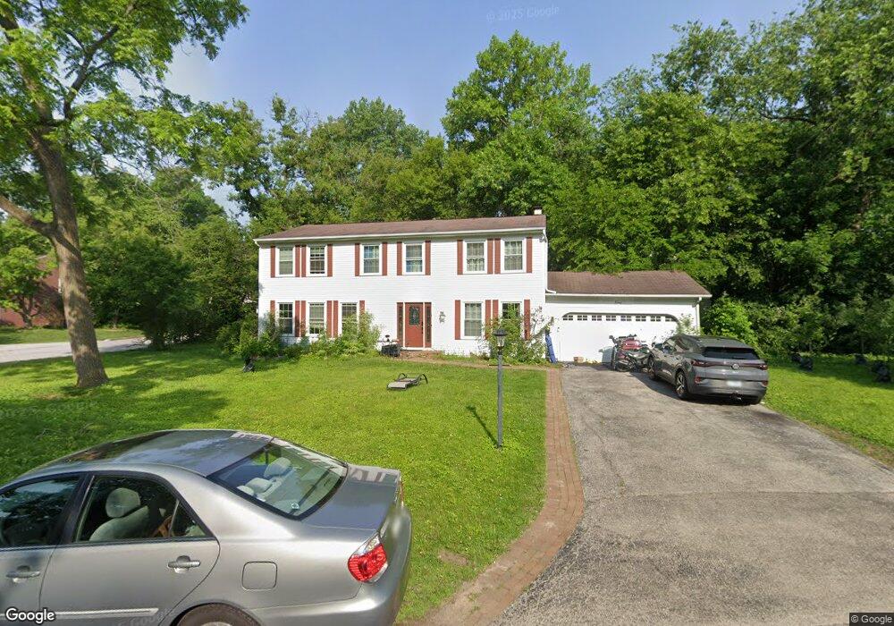
1 Stoneridge Rd Rolling Meadows, IL 60008
Creekside NeighborhoodEstimated Value: $530,000 - $676,000
5
Beds
3
Baths
2,520
Sq Ft
$248/Sq Ft
Est. Value
About This Home
This home is located at 1 Stoneridge Rd, Rolling Meadows, IL 60008 and is currently estimated at $623,752, approximately $247 per square foot. 1 Stoneridge Rd is a home located in Cook County with nearby schools including Central Road Elementary School, Plum Grove Jr High School, and William Fremd High School.
Ownership History
Date
Name
Owned For
Owner Type
Purchase Details
Closed on
Sep 26, 2007
Sold by
Csaszar Susan
Bought by
Chicago Title Land Trust Co and Trust #8002349454
Current Estimated Value
Purchase Details
Closed on
Aug 10, 2004
Sold by
Highberg Carle W
Bought by
Highberg Carle W and The Robert C Highberg Special Needs Trus
Purchase Details
Closed on
Nov 25, 1998
Sold by
Highberg Carle W and Highberg Mary C
Bought by
Highberg Carle W and Highberg Mary C
Create a Home Valuation Report for This Property
The Home Valuation Report is an in-depth analysis detailing your home's value as well as a comparison with similar homes in the area
Home Values in the Area
Average Home Value in this Area
Purchase History
| Date | Buyer | Sale Price | Title Company |
|---|---|---|---|
| Chicago Title Land Trust Co | $350,000 | First American Title | |
| Highberg Carle W | -- | -- | |
| Highberg Carle W | -- | -- |
Source: Public Records
Tax History
| Year | Tax Paid | Tax Assessment Tax Assessment Total Assessment is a certain percentage of the fair market value that is determined by local assessors to be the total taxable value of land and additions on the property. | Land | Improvement |
|---|---|---|---|---|
| 2025 | $13,476 | $59,000 | $11,668 | $47,332 |
| 2024 | $13,476 | $46,000 | $9,873 | $36,127 |
| 2023 | $12,943 | $46,000 | $9,873 | $36,127 |
| 2022 | $12,943 | $46,000 | $9,873 | $36,127 |
| 2021 | $11,821 | $37,910 | $6,282 | $31,628 |
| 2020 | $11,710 | $37,910 | $6,282 | $31,628 |
| 2019 | $11,772 | $42,358 | $6,282 | $36,076 |
| 2018 | $12,992 | $42,238 | $5,834 | $36,404 |
| 2017 | $12,745 | $42,238 | $5,834 | $36,404 |
| 2016 | $12,131 | $42,238 | $5,834 | $36,404 |
| 2015 | $11,740 | $38,606 | $5,385 | $33,221 |
| 2014 | $11,505 | $38,606 | $5,385 | $33,221 |
| 2013 | $11,203 | $38,606 | $5,385 | $33,221 |
Source: Public Records
Map
Nearby Homes
- 3 Holyoke on Auburn
- 3000 California Ave
- 2650 Brookwood Way Dr Unit 313
- 2650 Brookwood Way Dr Unit 108
- 2600 Brookwood Way Dr Unit 316
- 2600 Brookwood Way Dr Unit 305
- 304 E Tall Trees Ln
- 86 Brookdale Ln
- 399 Knollwood Ct
- 4795 Woodcliff Ln
- 3345 Kirchoff Rd Unit 5C
- 2136 Linden Ln
- 3265 Kirchoff Rd Unit 116
- 2401 Rohlwing Rd
- 3135 Town Square Dr Unit 401
- 3135 Town Square Dr Unit 104
- 1 Harrogate on Oxford
- 2 Croydon on Duxbury
- 3200 Thrush Ln
- 3100 Town Square Dr Unit 308
- 3 Stoneridge Rd
- 2 Stoneridge Rd
- 4 Stoneridge Rd
- 5 Stoneridge Rd
- 12 Rumford on Asbury
- 1 Applejack Rd
- 2 Rosewood Rd
- 3 Rumford on Asbury
- 1 Rosewood Rd Unit 4
- 3 Applejack Rd
- 1 Juniper Rd
- 10 Rumford on Asbury
- 3 Juniper Rd
- 1 Wildwood Rd
- 1 Rumford on Asbury
- 8 Rumford on Asbury
- 3008 Oaksbury Ct
- 6 Rumford on Asbury
- 3 Wildwood Rd
- 3 Pepperell on Asbury
Your Personal Tour Guide
Ask me questions while you tour the home.