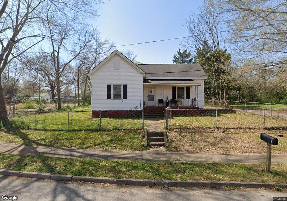
1 Thornton St Lagrange, GA 30241
Estimated Value: $92,000 - $138,000
3
Beds
1
Bath
1,530
Sq Ft
$75/Sq Ft
Est. Value
About This Home
This home is located at 1 Thornton St, Lagrange, GA 30241 and is currently estimated at $114,515, approximately $74 per square foot. 1 Thornton St is a home located in Troup County with nearby schools including Franklin Forest Elementary School, Hollis Hand Elementary School, and Ethel W. Kight Elementary School.
Ownership History
Date
Name
Owned For
Owner Type
Purchase Details
Closed on
Dec 16, 2005
Sold by
King Stephen C
Bought by
Emerson Thavin and Emerson Lisa
Current Estimated Value
Home Financials for this Owner
Home Financials are based on the most recent Mortgage that was taken out on this home.
Original Mortgage
$52,800
Outstanding Balance
$29,524
Interest Rate
6.28%
Mortgage Type
New Conventional
Estimated Equity
$84,991
Purchase Details
Closed on
Jul 20, 1999
Sold by
Pete Bryan W W
Bought by
King Stephen C
Purchase Details
Closed on
Jun 23, 1989
Sold by
Vera Nell Murphy
Bought by
Pete Bryan W W
Purchase Details
Closed on
Oct 17, 1983
Sold by
Ronnie Reece
Bought by
Vera Nell Murphy
Purchase Details
Closed on
Jan 3, 1977
Sold by
Adamson Elmer J and Adamson Willene S
Bought by
Ronnie Reece
Purchase Details
Closed on
Jan 1, 1965
Sold by
Hart Cora A and Hart Betty J
Bought by
Adamson Elmer J and Adamson Willene S
Create a Home Valuation Report for This Property
The Home Valuation Report is an in-depth analysis detailing your home's value as well as a comparison with similar homes in the area
Home Values in the Area
Average Home Value in this Area
Purchase History
| Date | Buyer | Sale Price | Title Company |
|---|---|---|---|
| Emerson Thavin | $66,000 | -- | |
| King Stephen C | $23,000 | -- | |
| Pete Bryan W W | $27,000 | -- | |
| Vera Nell Murphy | -- | -- | |
| Ronnie Reece | $11,500 | -- | |
| Adamson Elmer J | -- | -- |
Source: Public Records
Mortgage History
| Date | Status | Borrower | Loan Amount |
|---|---|---|---|
| Open | Emerson Thavin | $52,800 |
Source: Public Records
Tax History Compared to Growth
Tax History
| Year | Tax Paid | Tax Assessment Tax Assessment Total Assessment is a certain percentage of the fair market value that is determined by local assessors to be the total taxable value of land and additions on the property. | Land | Improvement |
|---|---|---|---|---|
| 2024 | $897 | $32,880 | $4,840 | $28,040 |
| 2023 | $734 | $26,920 | $4,840 | $22,080 |
| 2022 | $717 | $25,680 | $4,840 | $20,840 |
| 2021 | $648 | $21,484 | $3,280 | $18,204 |
| 2020 | $648 | $21,484 | $3,280 | $18,204 |
| 2019 | $546 | $18,120 | $3,280 | $14,840 |
| 2018 | $554 | $18,372 | $3,312 | $15,060 |
| 2017 | $554 | $18,372 | $3,312 | $15,060 |
| 2016 | $541 | $17,938 | $3,312 | $14,626 |
| 2015 | $542 | $17,938 | $3,312 | $14,626 |
| 2014 | $520 | $17,169 | $3,312 | $13,857 |
| 2013 | -- | $18,455 | $3,312 | $15,143 |
Source: Public Records
Map
Nearby Homes
- 15 Fulton St
- 5 Curran Ave
- 906 Georgia Ave
- 0 E Render St
- 902 Georgia Ave
- 130 Clara Jean Ct
- 0 N Barnard Ave
- Coleman Plan at Crossvine Village
- 0 Mill Creek Pkwy Unit PHASE 5 10313564
- Beckman Plan at Crossvine Village
- 0 Mill Creek Pkwy Unit PHASE 4 10313585
- Fairfield Plan at Crossvine Village
- Broadmoor Plan at Crossvine Village
- Dover Plan at Crossvine Village
- 113 Lenox Cir
- 121 de Groat St
- 128 Shenandoah Ln Unit A67
- 621 Arthur St
- 124 Shenandoah Ln
- 305 Lenox Cir