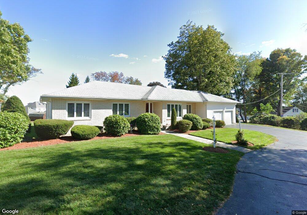
1 Upland St Auburn, MA 01501
Pakachoag NeighborhoodEstimated Value: $518,000 - $638,000
3
Beds
3
Baths
1,978
Sq Ft
$290/Sq Ft
Est. Value
About This Home
This home is located at 1 Upland St, Auburn, MA 01501 and is currently estimated at $574,337, approximately $290 per square foot. 1 Upland St is a home located in Worcester County with nearby schools including Auburn Senior High School and Shrewsbury Montessori School - Auburn Campus.
Ownership History
Date
Name
Owned For
Owner Type
Purchase Details
Closed on
Jun 30, 2015
Sold by
Sarkisian Nancy L
Bought by
Sarkisian Rt and Sarkisian Nancy L
Current Estimated Value
Purchase Details
Closed on
Feb 8, 1974
Bought by
Sarkisian Rt
Create a Home Valuation Report for This Property
The Home Valuation Report is an in-depth analysis detailing your home's value as well as a comparison with similar homes in the area
Home Values in the Area
Average Home Value in this Area
Purchase History
| Date | Buyer | Sale Price | Title Company |
|---|---|---|---|
| Sarkisian Rt | -- | -- | |
| Sarkisian Rt | -- | -- |
Source: Public Records
Mortgage History
| Date | Status | Borrower | Loan Amount |
|---|---|---|---|
| Previous Owner | Sarkisian Rt | $150,000 | |
| Previous Owner | Sarkisian Rt | $100,000 | |
| Previous Owner | Sarkisian Rt | $163,000 |
Source: Public Records
Tax History Compared to Growth
Tax History
| Year | Tax Paid | Tax Assessment Tax Assessment Total Assessment is a certain percentage of the fair market value that is determined by local assessors to be the total taxable value of land and additions on the property. | Land | Improvement |
|---|---|---|---|---|
| 2025 | $74 | $519,300 | $119,000 | $400,300 |
| 2024 | $7,649 | $512,300 | $114,500 | $397,800 |
| 2023 | $7,362 | $463,600 | $104,100 | $359,500 |
| 2022 | $6,740 | $400,700 | $104,100 | $296,600 |
| 2021 | $6,721 | $370,500 | $92,000 | $278,500 |
| 2020 | $6,662 | $370,500 | $92,000 | $278,500 |
| 2019 | $6,309 | $342,500 | $91,100 | $251,400 |
| 2018 | $3,490 | $335,100 | $85,200 | $249,900 |
| 2017 | $7,318 | $324,700 | $77,200 | $247,500 |
| 2016 | $6,287 | $316,400 | $79,600 | $236,800 |
| 2015 | $5,275 | $305,600 | $79,600 | $226,000 |
| 2014 | -- | $289,400 | $75,700 | $213,700 |
Source: Public Records
Map
Nearby Homes
- 204-212 Hampton St
- 61 Elmwood St
- 22 Lesley Ave
- 37 Elmwood St
- 6 Newton St
- 2 Breezy Bend
- 3 Lower Windbrook Dr
- 47 Washington St Unit 26
- 30 Davenport St
- 72 Sophia Dr
- 326 Pakachoag St
- 55 Tennyson St
- 2 Mystic St
- 29 Steele St
- 10 Steele St
- 557 SW Cutoff Unit 107
- 557 SW Cutoff Unit 17
- 557 SW Cutoff Unit 79
- 557 SW Cutoff Unit 35
- 31 Walsh Ave