Estimated Value: $639,000 - $732,000
4
Beds
2
Baths
1,706
Sq Ft
$412/Sq Ft
Est. Value
About This Home
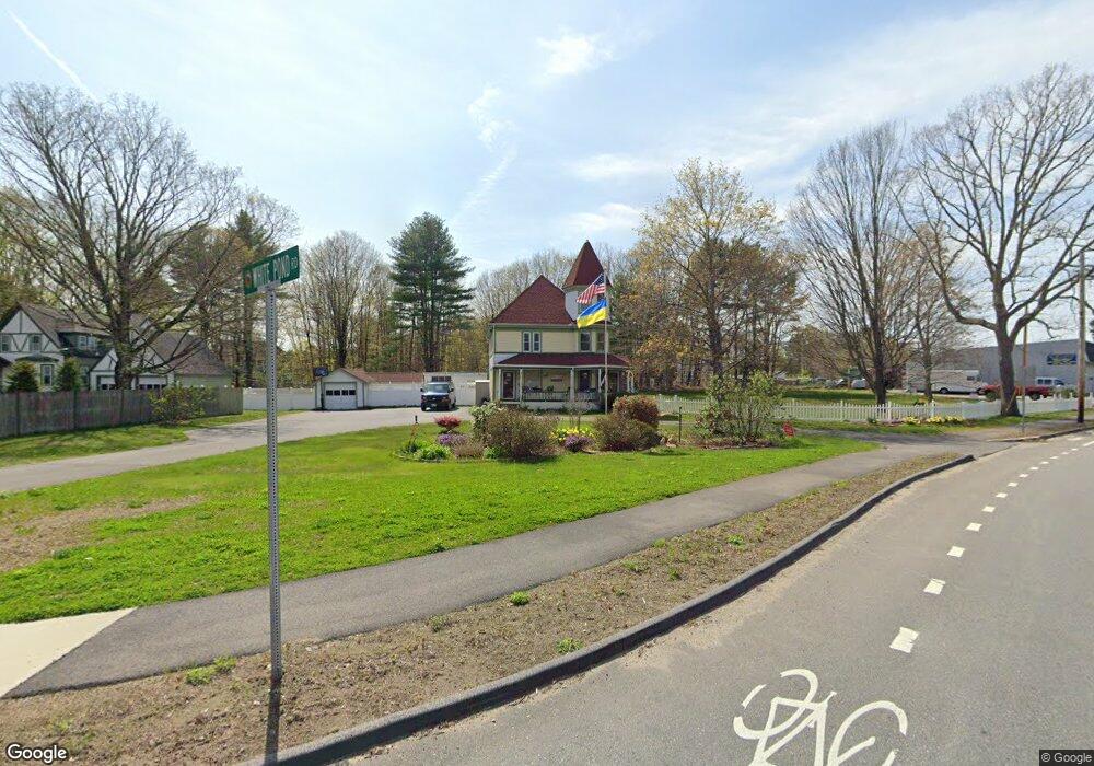
This home is located at 1 White Pond Rd, Stow, MA 01775 and is currently estimated at $703,008, approximately $412 per square foot. 1 White Pond Rd is a home located in Middlesex County with nearby schools including Center School, Hale Middle School, and Nashoba Regional High School.
Ownership History
Date
Name
Owned For
Owner Type
Purchase Details
Closed on
Sep 23, 2025
Sold by
Fisher Kathleen A
Bought by
Kathleen A Fisher T A and Kathleen Fisher
Current Estimated Value
Purchase Details
Closed on
May 13, 2004
Sold by
Huntley Emma M and Huntley Susan E
Bought by
Fisher Kathleen A
Home Financials for this Owner
Home Financials are based on the most recent Mortgage that was taken out on this home.
Original Mortgage
$320,600
Interest Rate
5.47%
Mortgage Type
Purchase Money Mortgage
Create a Home Valuation Report for This Property
The Home Valuation Report is an in-depth analysis detailing your home's value as well as a comparison with similar homes in the area
Home Values in the Area
Average Home Value in this Area
Purchase History
| Date | Buyer | Sale Price | Title Company |
|---|---|---|---|
| Kathleen A Fisher T A | -- | -- | |
| Fisher Kathleen A | $427,500 | -- | |
| Fisher Kathleen A | $427,500 | -- |
Source: Public Records
Mortgage History
| Date | Status | Borrower | Loan Amount |
|---|---|---|---|
| Previous Owner | Fisher Kathleen A | $303,000 | |
| Previous Owner | Fisher Kathleen A | $320,600 |
Source: Public Records
Tax History
| Year | Tax Paid | Tax Assessment Tax Assessment Total Assessment is a certain percentage of the fair market value that is determined by local assessors to be the total taxable value of land and additions on the property. | Land | Improvement |
|---|---|---|---|---|
| 2025 | $10,485 | $601,900 | $325,800 | $276,100 |
| 2024 | $9,751 | $574,600 | $298,500 | $276,100 |
| 2023 | $9,350 | $515,700 | $271,400 | $244,300 |
| 2022 | $9,088 | $464,600 | $226,000 | $238,600 |
| 2021 | $8,366 | $418,700 | $203,400 | $215,300 |
| 2020 | $8,050 | $390,600 | $188,100 | $202,500 |
| 2019 | $7,788 | $386,900 | $188,100 | $198,800 |
| 2018 | $7,815 | $372,500 | $188,100 | $184,400 |
| 2017 | $7,937 | $385,500 | $190,000 | $195,500 |
| 2016 | $7,742 | $387,500 | $173,900 | $213,600 |
| 2015 | $7,191 | $359,900 | $162,600 | $197,300 |
Source: Public Records
Map
Nearby Homes
- 34 Meeting House Ln Unit 208
- 153 Summer St
- 10 Mill St Unit B
- 12 S Acton Rd
- 15 Crescent St
- 40 Saw Mill Rd
- 41 Taylor Rd
- 414 Great Rd
- 30-6 Taylor Rd
- 247 W Acton Rd
- 12 Brown St
- 36 Brown St
- 280 W Acton Rd
- 63 Conant St
- 13 Arthur St Unit 15
- 22 Douglas Ave Unit 2
- 22 Douglas Ave Unit 1
- 5 Hayes St Unit 5
- 31-33 Roosevelt St
- 66 Powder Mill Rd
- 9 White Pond Rd
- 11 White Pond Rd
- 15 Heritage Ln
- 1 Pompositticut St
- 10 White Pond Rd
- 5 Red Acre Rd
- 21 Heritage Ln
- 16 Heritage Ln
- 108 Great Rd
- 25 White Pond Rd
- 25 Heritage Ln
- 9 Red Acre Rd
- 59 Great Rd
- 20 Heritage Ln
- 60 Great Rd
- 29 White Pond Rd
- 13 Red Acre Rd
- 26 Heritage Ln
- 29 Heritage Ln
- 22 Pompositticutt St
Your Personal Tour Guide
Ask me questions while you tour the home.