
Seller's Agent in 2025
Darren De Wilde
EXP Realty
(866) 201-6210
1 in this area
2 Total Sales
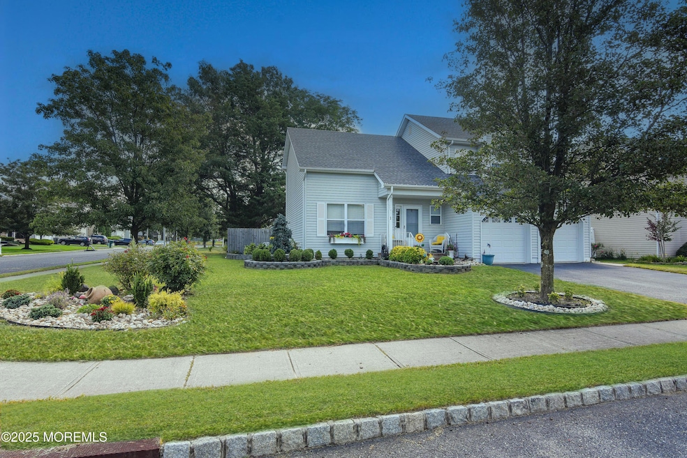


Welcome to beautiful and desirable Ramtown!
Discover this charming 3-bedroom, 2.5-bath Colonial offering the perfect blend of comfort, style, and convenience. Enjoy a formal living and dining room, plus a kitchen that opens seamlessly to the cozy family room with sliders leading to the backyard—creating an ideal layout for everyday living and entertaining. The main level features gleaming hardwood floors and an updated kitchen with modern finishes. Upstairs, you'll find three spacious bedrooms and two full baths.
Step outside to a beautifully manicured lawn with tasteful landscaping, complemented by a fully fenced, oversized backyard—perfect for gatherings, pets, or simply relaxing outdoors.
Conveniently located near the Garden State Parkway for an easy commute, this home truly has it all and more. Schedule your appointment today-you won't be disappointed!
Last Buyer's Agent
Scott Hartman
Redfin Corporation License #1433837
| Date | Type | Sale Price | Title Company |
|---|---|---|---|
| Deed | $665,000 | First American Title Insurance | |
| Deed | $33,523 | -- | |
| Deed | $171,925 | -- |
| Date | Status | Loan Amount | Loan Type |
|---|---|---|---|
| Open | $631,750 | New Conventional | |
| Previous Owner | -- | No Value Available | |
| Previous Owner | $130,000 | No Value Available |
| Date | Event | Price | List to Sale | Price per Sq Ft |
|---|---|---|---|---|
| 12/30/2025 12/30/25 | Sold | $665,000 | -1.5% | $393 / Sq Ft |
| 11/17/2025 11/17/25 | Pending | -- | -- | -- |
| 10/23/2025 10/23/25 | For Sale | $675,000 | -- | $399 / Sq Ft |
| Year | Tax Paid | Tax Assessment Tax Assessment Total Assessment is a certain percentage of the fair market value that is determined by local assessors to be the total taxable value of land and additions on the property. | Land | Improvement |
|---|---|---|---|---|
| 2025 | $9,347 | $602,800 | $261,000 | $341,800 |
| 2024 | $9,215 | $527,800 | $226,000 | $301,800 |
| 2023 | $9,215 | $495,700 | $201,000 | $294,700 |
| 2022 | $9,166 | $431,600 | $151,000 | $280,600 |
| 2021 | $9,166 | $400,600 | $151,000 | $249,600 |
| 2020 | $9,205 | $397,800 | $151,000 | $246,800 |
| 2019 | $9,281 | $393,600 | $151,000 | $242,600 |
| 2018 | $9,129 | $385,200 | $151,000 | $234,200 |
| 2017 | $8,478 | $353,700 | $121,000 | $232,700 |
| 2016 | $7,896 | $325,200 | $98,300 | $226,900 |
| 2015 | $7,666 | $312,400 | $86,000 | $226,400 |
| 2014 | $7,702 | $291,300 | $104,900 | $186,400 |
Seller's Agent in 2025
Darren De Wilde
EXP Realty
(866) 201-6210
1 in this area
2 Total Sales
S
Buyer's Agent in 2025
Scott Hartman
Redfin Corporation
Source: MOREMLS (Monmouth Ocean Regional REALTORS®)
MLS Number: 22532155
APN: 21-00003-03-00027
Disclaimer: Certain information contained herein is derived from information provided by parties other than Homes.com. All information provided is deemed reliable, but is not guaranteed to be accurate and should be independently verified.
![]() IDX information is provided exclusively for personal, non-commercial use, and may not be used for any purpose other than to identify prospective properties consumers may be interested in purchasing.
IDX information is provided exclusively for personal, non-commercial use, and may not be used for any purpose other than to identify prospective properties consumers may be interested in purchasing.
Information is deemed reliable but not guaranteed.
Ask me questions while you tour the home.