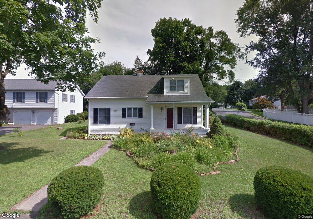
1 Wixted Ave Danbury, CT 06810
Estimated Value: $407,000 - $637,000
3
Beds
3
Baths
1,426
Sq Ft
$369/Sq Ft
Est. Value
About This Home
This home is located at 1 Wixted Ave, Danbury, CT 06810 and is currently estimated at $526,851, approximately $369 per square foot. 1 Wixted Ave is a home located in Fairfield County with nearby schools including Shelter Rock School, Rogers Park Middle School, and Danbury High School.
Ownership History
Date
Name
Owned For
Owner Type
Purchase Details
Closed on
Mar 24, 1999
Sold by
Block Lonny and Block Vanessa
Bought by
Ellis Robert J and Ellis Laura L
Current Estimated Value
Home Financials for this Owner
Home Financials are based on the most recent Mortgage that was taken out on this home.
Original Mortgage
$150,100
Interest Rate
6.78%
Purchase Details
Closed on
Oct 1, 1998
Sold by
Ramey Jeanne J
Bought by
Block Lonny P and Block Vanessa W
Home Financials for this Owner
Home Financials are based on the most recent Mortgage that was taken out on this home.
Original Mortgage
$124,000
Interest Rate
6.89%
Purchase Details
Closed on
Jul 30, 1997
Sold by
Ramey Jeane
Bought by
Brar Satwinder and Sidhu Jaspreet
Home Financials for this Owner
Home Financials are based on the most recent Mortgage that was taken out on this home.
Original Mortgage
$185,250
Interest Rate
7.55%
Mortgage Type
Unknown
Create a Home Valuation Report for This Property
The Home Valuation Report is an in-depth analysis detailing your home's value as well as a comparison with similar homes in the area
Home Values in the Area
Average Home Value in this Area
Purchase History
| Date | Buyer | Sale Price | Title Company |
|---|---|---|---|
| Ellis Robert J | $158,000 | -- | |
| Block Lonny P | $155,000 | -- | |
| Brar Satwinder | $195,000 | -- |
Source: Public Records
Mortgage History
| Date | Status | Borrower | Loan Amount |
|---|---|---|---|
| Open | Brar Satwinder | $224,000 | |
| Closed | Brar Satwinder | $150,100 | |
| Previous Owner | Brar Satwinder | $124,000 | |
| Previous Owner | Brar Satwinder | $185,250 |
Source: Public Records
Tax History
| Year | Tax Paid | Tax Assessment Tax Assessment Total Assessment is a certain percentage of the fair market value that is determined by local assessors to be the total taxable value of land and additions on the property. | Land | Improvement |
|---|---|---|---|---|
| 2025 | $7,296 | $291,970 | $61,460 | $230,510 |
| 2024 | $7,136 | $291,970 | $61,460 | $230,510 |
| 2023 | $6,812 | $291,970 | $61,460 | $230,510 |
| 2022 | $5,686 | $201,500 | $64,700 | $136,800 |
| 2021 | $5,564 | $201,600 | $64,700 | $136,900 |
| 2020 | $5,564 | $201,600 | $64,700 | $136,900 |
| 2019 | $5,564 | $201,600 | $64,700 | $136,900 |
| 2018 | $5,564 | $201,600 | $64,700 | $136,900 |
| 2017 | $5,602 | $193,500 | $61,600 | $131,900 |
| 2016 | $5,550 | $193,500 | $61,600 | $131,900 |
| 2015 | $5,468 | $193,500 | $61,600 | $131,900 |
| 2014 | $3,513 | $127,300 | $62,700 | $64,600 |
Source: Public Records
Map
Nearby Homes
- 14 Morton St
- 11 Mannions Ln Unit 11
- 10 Sampson Terrace
- 110 Coalpit Hill Rd Unit C8
- 10 South St Unit 36
- 175 South St
- 18 Hudson St Unit 21
- 26 Mountainville Rd
- 92 Woodcrest Ln
- 163 South St Unit 85
- 163 South St Unit 19
- 168 South St
- 15A Mountainville Rd
- 8 Housman St
- 126 Triangle St Unit A16
- 126 Triangle St Unit B10
- 126 Triangle St Unit B51
- 126 Triangle St Unit A32
- 14 Fleetwood Park
- 35 Taylor St
Your Personal Tour Guide
Ask me questions while you tour the home.