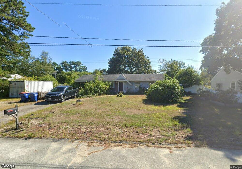
10 Acoaxet Ln West Wareham, MA 02576
Estimated Value: $434,197 - $471,000
3
Beds
1
Bath
1,201
Sq Ft
$379/Sq Ft
Est. Value
About This Home
This home is located at 10 Acoaxet Ln, West Wareham, MA 02576 and is currently estimated at $455,049, approximately $378 per square foot. 10 Acoaxet Ln is a home located in Plymouth County.
Ownership History
Date
Name
Owned For
Owner Type
Purchase Details
Closed on
Sep 22, 1999
Sold by
Triple J Rt and Hoban Jacquelyn
Bought by
Donaher Joseph R
Current Estimated Value
Purchase Details
Closed on
Jul 8, 1999
Sold by
Associates Financial
Bought by
Coll Pierre M and Sachetti Richard
Purchase Details
Closed on
Jun 30, 1999
Sold by
Halpern Aaron J
Bought by
Associates Fincl Svcs
Create a Home Valuation Report for This Property
The Home Valuation Report is an in-depth analysis detailing your home's value as well as a comparison with similar homes in the area
Home Values in the Area
Average Home Value in this Area
Purchase History
| Date | Buyer | Sale Price | Title Company |
|---|---|---|---|
| Donaher Joseph R | $110,900 | -- | |
| Donaher Joseph R | $110,900 | -- | |
| Coll Pierre M | $62,000 | -- | |
| Coll Pierre M | $62,000 | -- | |
| Associates Fincl Svcs | $75,000 | -- | |
| Associates Fincl Svcs | $75,000 | -- |
Source: Public Records
Mortgage History
| Date | Status | Borrower | Loan Amount |
|---|---|---|---|
| Open | Associates Fincl Svcs | $75,000 | |
| Closed | Associates Fincl Svcs | $94,457 |
Source: Public Records
Tax History
| Year | Tax Paid | Tax Assessment Tax Assessment Total Assessment is a certain percentage of the fair market value that is determined by local assessors to be the total taxable value of land and additions on the property. | Land | Improvement |
|---|---|---|---|---|
| 2025 | $3,574 | $343,000 | $109,800 | $233,200 |
| 2024 | $3,426 | $305,100 | $85,800 | $219,300 |
| 2023 | $3,091 | $273,200 | $78,000 | $195,200 |
| 2022 | $3,091 | $234,500 | $78,000 | $156,500 |
| 2021 | $3,057 | $227,300 | $78,000 | $149,300 |
| 2020 | $2,855 | $215,300 | $78,000 | $137,300 |
| 2019 | $2,654 | $199,700 | $75,000 | $124,700 |
| 2018 | $2,509 | $184,100 | $75,000 | $109,100 |
| 2017 | $2,326 | $172,900 | $75,000 | $97,900 |
| 2016 | $2,123 | $156,900 | $72,500 | $84,400 |
| 2015 | $2,051 | $156,900 | $72,500 | $84,400 |
| 2014 | $2,023 | $157,400 | $68,900 | $88,500 |
Source: Public Records
Map
Nearby Homes
Your Personal Tour Guide
Ask me questions while you tour the home.