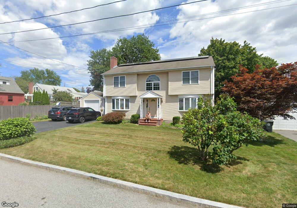
10 Ashburton Rd East Providence, RI 02914
Kent Heights NeighborhoodEstimated Value: $438,000 - $570,000
3
Beds
4
Baths
2,688
Sq Ft
$199/Sq Ft
Est. Value
About This Home
This home is located at 10 Ashburton Rd, East Providence, RI 02914 and is currently estimated at $533,902, approximately $198 per square foot. 10 Ashburton Rd is a home located in Providence County with nearby schools including East Providence High School, The Gordon School, and St Mary Academy-Bay View.
Ownership History
Date
Name
Owned For
Owner Type
Purchase Details
Closed on
Oct 29, 2024
Sold by
Edward and Edward Lillian N
Bought by
Quiroa Ernesto A and Jiminez Jenny
Current Estimated Value
Home Financials for this Owner
Home Financials are based on the most recent Mortgage that was taken out on this home.
Original Mortgage
$385,590
Outstanding Balance
$381,420
Interest Rate
6.2%
Mortgage Type
Purchase Money Mortgage
Estimated Equity
$152,482
Purchase Details
Closed on
Mar 12, 2002
Sold by
Small Glenn C and Small Elizabeth
Bought by
Batty Kristen
Purchase Details
Closed on
Dec 7, 1994
Sold by
Smail Donald Sherry and Smail Gayle
Bought by
Smail Glenn C and Smail Elizabeth
Create a Home Valuation Report for This Property
The Home Valuation Report is an in-depth analysis detailing your home's value as well as a comparison with similar homes in the area
Home Values in the Area
Average Home Value in this Area
Purchase History
| Date | Buyer | Sale Price | Title Company |
|---|---|---|---|
| Quiroa Ernesto A | $400,000 | None Available | |
| Quiroa Ernesto A | $400,000 | None Available | |
| Batty Kristen | $45,500 | -- | |
| Smail Glenn C | $125,000 | -- | |
| Batty Kristen | $45,500 | -- | |
| Smail Glenn C | $125,000 | -- |
Source: Public Records
Mortgage History
| Date | Status | Borrower | Loan Amount |
|---|---|---|---|
| Open | Quiroa Ernesto A | $385,590 | |
| Closed | Quiroa Ernesto A | $385,590 | |
| Previous Owner | Smail Glenn C | $100,000 | |
| Previous Owner | Smail Glenn C | $175,000 | |
| Previous Owner | Smail Glenn C | $44,668 |
Source: Public Records
Tax History Compared to Growth
Tax History
| Year | Tax Paid | Tax Assessment Tax Assessment Total Assessment is a certain percentage of the fair market value that is determined by local assessors to be the total taxable value of land and additions on the property. | Land | Improvement |
|---|---|---|---|---|
| 2025 | $9,111 | $697,100 | $154,600 | $542,500 |
| 2024 | $8,355 | $545,000 | $128,900 | $416,100 |
| 2023 | $8,044 | $545,000 | $128,900 | $416,100 |
| 2022 | $9,594 | $438,900 | $92,700 | $346,200 |
| 2021 | $9,436 | $438,900 | $92,700 | $346,200 |
| 2020 | $9,037 | $438,900 | $92,700 | $346,200 |
| 2019 | $8,787 | $438,900 | $92,700 | $346,200 |
| 2018 | $9,422 | $411,800 | $102,600 | $309,200 |
| 2017 | $9,212 | $411,800 | $102,600 | $309,200 |
| 2016 | $9,167 | $411,800 | $102,600 | $309,200 |
| 2015 | $8,409 | $366,400 | $52,800 | $313,600 |
| 2014 | $8,409 | $366,400 | $52,800 | $313,600 |
Source: Public Records
Map
Nearby Homes
- 53 Wampanoag Trail
- 36 Gerald St
- 10 Fairfield Ave
- 180 Grassmere Ave
- 108 Ivan Ave
- 25 Ide Ave
- 87 Vincent Ave
- 59 Merritt Rd
- 74 Brookhaven Dr
- 50 Kettle Point Ave Unit 50
- 740 Veterans Memorial Pkwy
- 1463 S Broadway
- 26 Mayflower St
- 132 S Rose St
- 75 Belmont Ave
- 14 Waterview Ave Unit 16
- 17 Brown St Unit 19
- 400 Juniper St Unit A
- 400 Juniper St Unit B
- 400 Juniper St Unit C