Estimated Value: $1,235,996 - $1,391,000
4
Beds
3
Baths
3,139
Sq Ft
$427/Sq Ft
Est. Value
About This Home
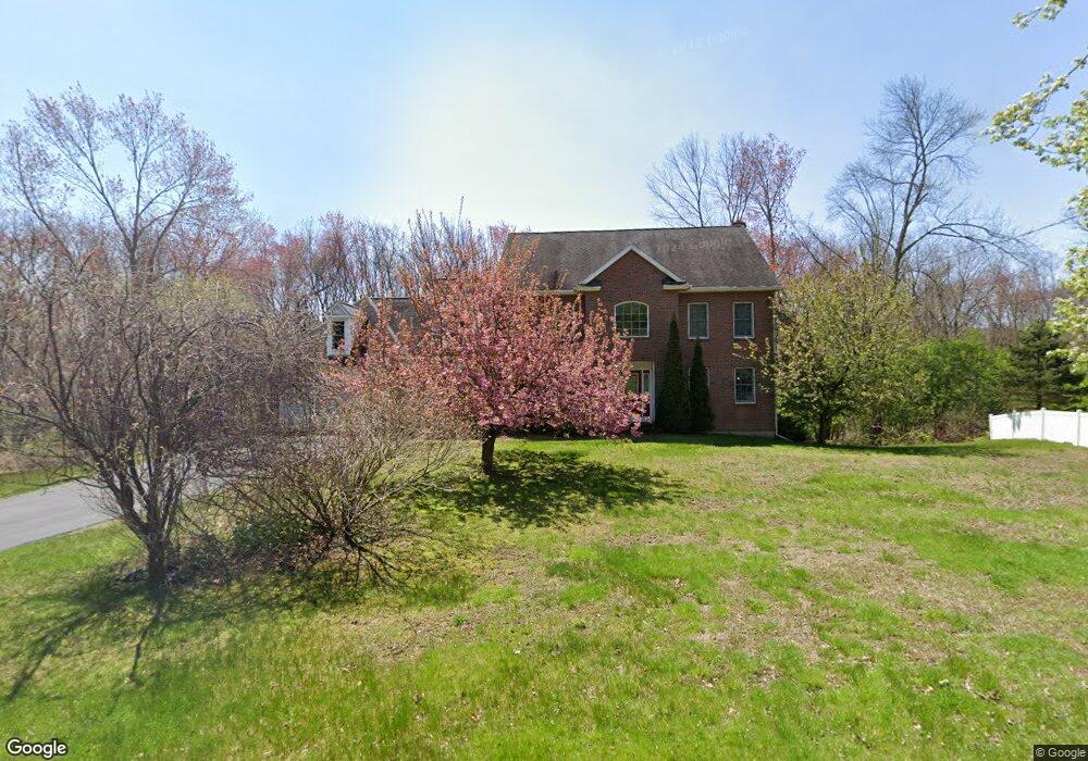
This home is located at 10 Barker Rd, Acton, MA 01720 and is currently estimated at $1,340,999, approximately $427 per square foot. 10 Barker Rd is a home located in Middlesex County with nearby schools including Acton-Boxborough Regional High School and Nashoba Brooks School.
Ownership History
Date
Name
Owned For
Owner Type
Purchase Details
Closed on
Sep 17, 2004
Sold by
Ho Jessica Yun Jo and Cai Qun
Bought by
Narasimhan Jayanthi S and Narasimhan Narayana I
Current Estimated Value
Home Financials for this Owner
Home Financials are based on the most recent Mortgage that was taken out on this home.
Original Mortgage
$614,400
Outstanding Balance
$307,228
Interest Rate
6.02%
Mortgage Type
Purchase Money Mortgage
Estimated Equity
$1,033,771
Purchase Details
Closed on
Aug 18, 1999
Sold by
Pettingell Mass Ft and Pettingell Richard G
Bought by
Cai Qun and Ho Yun-Jo
Home Financials for this Owner
Home Financials are based on the most recent Mortgage that was taken out on this home.
Original Mortgage
$111,000
Interest Rate
7.6%
Mortgage Type
Purchase Money Mortgage
Create a Home Valuation Report for This Property
The Home Valuation Report is an in-depth analysis detailing your home's value as well as a comparison with similar homes in the area
Home Values in the Area
Average Home Value in this Area
Purchase History
| Date | Buyer | Sale Price | Title Company |
|---|---|---|---|
| Narasimhan Jayanthi S | $768,000 | -- | |
| Cai Qun | $161,000 | -- |
Source: Public Records
Mortgage History
| Date | Status | Borrower | Loan Amount |
|---|---|---|---|
| Open | Cai Qun | $250,000 | |
| Closed | Cai Qun | $250,000 | |
| Open | Narasimhan Jayanthi S | $614,400 | |
| Previous Owner | Cai Qun | $191,000 | |
| Previous Owner | Cai Qun | $111,000 |
Source: Public Records
Tax History Compared to Growth
Tax History
| Year | Tax Paid | Tax Assessment Tax Assessment Total Assessment is a certain percentage of the fair market value that is determined by local assessors to be the total taxable value of land and additions on the property. | Land | Improvement |
|---|---|---|---|---|
| 2025 | $19,819 | $1,155,600 | $351,400 | $804,200 |
| 2024 | $18,409 | $1,104,300 | $351,400 | $752,900 |
| 2023 | $18,294 | $1,041,800 | $319,200 | $722,600 |
| 2022 | $17,254 | $887,100 | $277,600 | $609,500 |
| 2021 | $16,888 | $834,800 | $257,600 | $577,200 |
| 2020 | $15,906 | $826,700 | $257,600 | $569,100 |
| 2019 | $15,626 | $806,700 | $257,600 | $549,100 |
| 2018 | $15,299 | $789,400 | $257,600 | $531,800 |
| 2017 | $14,882 | $780,800 | $257,600 | $523,200 |
| 2016 | $14,976 | $778,800 | $285,600 | $493,200 |
| 2015 | $14,733 | $773,400 | $285,600 | $487,800 |
| 2014 | $14,115 | $725,700 | $285,600 | $440,100 |
Source: Public Records
Map
Nearby Homes
- 46 Taylor Rd
- 11 Braebrook
- 7 Kelley Rd
- 246 Main St Unit 2
- 491 Main St
- 33 Meadowbrook Rd
- 70 River St
- 129 Main St Unit 129
- 131 Main St
- 709 Main St
- 19 Railroad St Unit D2
- 19 Railroad St Unit C2
- 40 High St
- 524 Main St
- 187 Great Rd Unit A1
- 128 Parker St Unit 3B
- 4,7,8 Crestwood Ln
- 132 Parker St Unit G5
- 116 Windsor Ave
- 285 Central St Unit 285