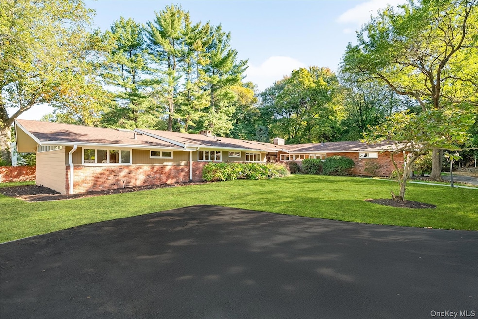
10 Barnaby Ln Hartsdale, NY 10530
Estimated payment $10,107/month
Highlights
- Eat-In Gourmet Kitchen
- Property is near public transit
- Ranch Style House
- 0.84 Acre Lot
- Private Lot
- Wood Flooring
About This Home
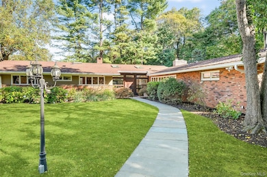
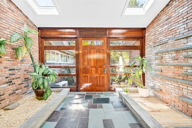
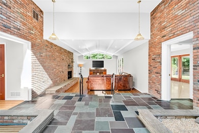
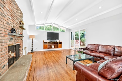
“Home in Hartsdale” Welcome to this beautifully maintained mid-century modern gem, offering privacy, space, and timeless design. Nestled on a quiet lane, this 4,300-square-foot home features five spacious bedrooms, including two en-suites, and a total of four full bathrooms — perfect for comfortable living and effortless entertaining.
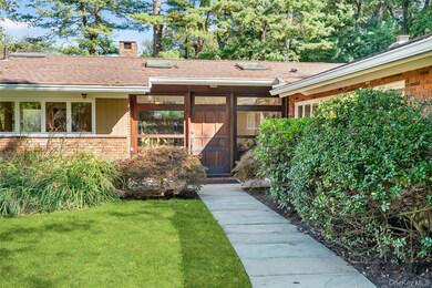
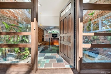
Step through the stunning front door, a true showstopper, into a unique and elegant foyer that sets the tone for the rest of the home. The large eat-in kitchen overlooks a serene, expansive backyard complete with a breathtaking bluestone patio — ideal for relaxing or hosting guests.
Two additional versatile rooms with backyard access offer endless possibilities: home office, playroom, gym, or guest suite — the choice is yours.
Located just minutes from Ridge Road Park, a variety of shops, restaurants, and all major conveniences, this home offers the perfect blend of tranquility and accessibility. Commuters will appreciate the short drive to Metro-North and other public transportation options.
If you're looking for a forever home that stands apart from the rest, look no further — 10 Barnaby Lane is ready to welcome you home.
Listing Agent
Howard Hanna Rand Realty Brokerage Phone: 845-735-3700 License #10401255461 Listed on: 10/16/2025

Co-Listing Agent
Howard Hanna Rand Realty Brokerage Phone: 845-735-3700 License #10401318678
Home Details
Home Type
- Single Family
Est. Annual Taxes
- $32,884
Year Built
- Built in 1959 | Remodeled in 2009
Lot Details
- 0.84 Acre Lot
- Wood Fence
- Landscaped
- Private Lot
- Level Lot
- Front and Back Yard Sprinklers
- Back Yard Fenced and Front Yard
Parking
- 2 Car Attached Garage
- Oversized Parking
- Heated Garage
- Garage Door Opener
- Driveway
Home Design
- Ranch Style House
- Brick Exterior Construction
- Frame Construction
- Clapboard
Interior Spaces
- 4,300 Sq Ft Home
- Built-In Features
- High Ceiling
- Recessed Lighting
- Wood Burning Fireplace
- Entrance Foyer
- Storage
Kitchen
- Eat-In Gourmet Kitchen
- Breakfast Bar
- Convection Oven
- Gas Cooktop
- Microwave
- Dishwasher
- Stainless Steel Appliances
- Granite Countertops
Flooring
- Wood
- Carpet
- Ceramic Tile
Bedrooms and Bathrooms
- 5 Bedrooms
- En-Suite Primary Bedroom
- Walk-In Closet
- Bathroom on Main Level
- 4 Full Bathrooms
Laundry
- Laundry Room
- Dryer
- Washer
Home Security
- Home Security System
- Security Lights
- Fire and Smoke Detector
Outdoor Features
- Covered Patio or Porch
- Exterior Lighting
- Rain Gutters
- Private Mailbox
Location
- Property is near public transit
- Property is near schools
- Property is near shops
- Property is near a golf course
Schools
- Lee F Jackson Elementary School
- Woodlands Middle/High School
Utilities
- Forced Air Heating and Cooling System
- Underground Utilities
- Natural Gas Connected
- Geothermal Hot Water System
- Gas Water Heater
- Septic Tank
- High Speed Internet
- Cable TV Available
Listing and Financial Details
- Assessor Parcel Number 2689-008-230-00175-000-0018
Map
Home Values in the Area
Average Home Value in this Area
Tax History
| Year | Tax Paid | Tax Assessment Tax Assessment Total Assessment is a certain percentage of the fair market value that is determined by local assessors to be the total taxable value of land and additions on the property. | Land | Improvement |
|---|---|---|---|---|
| 2024 | $26,867 | $1,204,100 | $245,800 | $958,300 |
| 2023 | $23,927 | $1,000,000 | $213,800 | $786,200 |
| 2022 | $23,054 | $955,800 | $213,800 | $742,000 |
| 2021 | $24,565 | $885,000 | $213,700 | $671,300 |
| 2020 | $24,554 | $901,500 | $267,100 | $634,400 |
| 2019 | $25,854 | $901,500 | $267,100 | $634,400 |
| 2018 | $34,286 | $885,400 | $267,100 | $618,300 |
| 2017 | $11,582 | $837,100 | $267,100 | $570,000 |
| 2016 | $425,136 | $804,900 | $267,100 | $537,800 |
| 2015 | -- | $26,900 | $4,350 | $22,550 |
| 2014 | -- | $26,900 | $4,350 | $22,550 |
| 2013 | $19,725 | $26,900 | $4,350 | $22,550 |
Property History
| Date | Event | Price | List to Sale | Price per Sq Ft |
|---|---|---|---|---|
| 11/06/2025 11/06/25 | Pending | -- | -- | -- |
| 10/16/2025 10/16/25 | For Sale | $1,395,000 | -- | $324 / Sq Ft |
Purchase History
| Date | Type | Sale Price | Title Company |
|---|---|---|---|
| Bargain Sale Deed | $887,500 | New York Title | |
| Bargain Sale Deed | $575,000 | First American Title Ins Co |
Mortgage History
| Date | Status | Loan Amount | Loan Type |
|---|---|---|---|
| Previous Owner | $375,000 | Purchase Money Mortgage |
Source: OneKey® MLS
MLS Number: 898790
APN: 2689-008-230-00175-000-0018
Disclaimer: Certain information contained herein is derived from information provided by parties other than Homes.com. All information provided is deemed reliable, but is not guaranteed to be accurate and should be independently verified.
![]() The data relating to real estate for sale or lease on this web site comes in part from OneKey® MLS. Real estate listings held by brokerage firms other than Ten-X are marked with the OneKey® MLS logo or an abbreviated logo and detailed information about them includes the name of the listing broker.
The data relating to real estate for sale or lease on this web site comes in part from OneKey® MLS. Real estate listings held by brokerage firms other than Ten-X are marked with the OneKey® MLS logo or an abbreviated logo and detailed information about them includes the name of the listing broker.
IDX information is provided exclusively for personal, non-commercial use, and may not be used for any purpose other than to identify prospective properties consumers may be interested in purchasing.
Information is deemed reliable but not guaranteed.
Copyright 2025 OneKey® MLS. All rights reserved.
- 17 Birchwood Ln
- 27 Hawthorne Way
- 6 Sunset Ln
- 46 Marion Ave
- 42 N Healy Ave
- 132 Holmes Ave
- 1 Thomas Ct
- 217 Moore St
- 372 Central Park Ave Unit 2E
- 635 Secor Rd
- 7 Secor Gln Rd
- 245 Lot 1 Secor Rd
- 245 Lot 2 Secor Rd
- 245 - Lot 4 Secor Rd
- 348 Central Park Ave Unit C15
- 348 Central Park Ave Unit C-24
- 334 Central Park Ave Unit H9
- 356 Central Park Ave Unit E 10
- 12 Jennifer Ln
- 370 Central Park Ave Unit 3D