
10 Broad St Cranford, NJ 07016
Highlights
- 0.12 Acre Lot
- Deck
- Home Office
- Cranford Sr High School Rated A-
- Wood Flooring
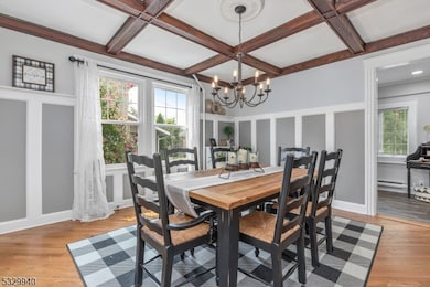
- Formal Dining Room
About This Home
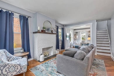
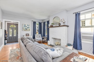
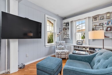
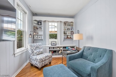
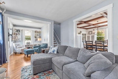
Picture-perfect single-family house rental that is pet-friendly with a fenced in yard! 1st fl. features LR, Den, Office, Formal DR, Kitchen, Powder Room. 2nd Fl. features 3 bedrooms + full bath. Basement is partially finished & furnished (see pic), laundry room with washer + dryer, & has great storage space. Backyard features deck and nice yard. 1 car detached garage and spacious driveway. Awesome location - CLOSE to downtown Cranford - train station! Tenant application, NTN background/credit check, income verification, renter's insurance all required. NO SMOKING.
Listing Agent
DIANA DOLLARD HEARNS
COLDWELL BANKER REALTY Brokerage Phone: 908-656-5940 Listed on: 11/29/2025
Home Details
Home Type
- Single Family
Est. Annual Taxes
- $9,525
Year Built
- Built in 1915
Parking
- 1 Car Detached Garage
- Paver Block
Home Design
- Tile
Interior Spaces
- 3-Story Property
- Ceiling Fan
- Window Treatments
- Entrance Foyer
- Family Room
- Living Room
- Formal Dining Room
- Home Office
- Storage Room
- Utility Room
- Wood Flooring
- Partially Finished Basement
Kitchen
- Electric Oven or Range
- Microwave
- Dishwasher
Bedrooms and Bathrooms
- 3 Bedrooms
- Primary bedroom located on second floor
- Powder Room
Laundry
- Laundry Room
- Dryer
- Washer
Home Security
- Carbon Monoxide Detectors
- Fire and Smoke Detector
Schools
- Hillside Elementary And Middle School
- Cranford High School
Utilities
- Window Unit Cooling System
- Water Tap or Transfer Fee
Additional Features
- Deck
- 5,300 Sq Ft Lot
Community Details
- Limit on the number of pets
Listing and Financial Details
- Tenant pays for cable t.v., electric, gas, hot water, maintenance-lawn, snow removal, trash removal, water
- Assessor Parcel Number 2903-00519-0000-00013-0000-
Map
Source: Garden State MLS
MLS Number: 3999637
APN: 03-00519-0000-00013
Disclaimer: Certain information contained herein is derived from information provided by parties other than Homes.com. All information provided is deemed reliable, but is not guaranteed to be accurate and should be independently verified.
![]() The data relating to real estate for sale on this website comes in part from the IDX Program of Garden State Multiple Listing Service, L.L.C. Real estate listings held by other brokerage firms are marked as IDX Listing.
The data relating to real estate for sale on this website comes in part from the IDX Program of Garden State Multiple Listing Service, L.L.C. Real estate listings held by other brokerage firms are marked as IDX Listing.
Information deemed reliable but not guaranteed.
Copyright © 2025 Garden State Multiple Listing Service, L.L.C. All rights reserved.
Notice: The dissemination of listings on this website does not constitute the consent required by N.J.A.C. 11:5.6.1 (n) for the advertisement of listings exclusively for sale by another broker. Any such consent must be obtained in writing from the listing broker.
This information is being provided for Consumers’ personal, non-commercial use and may not be used for any purpose other than to identify prospective properties Consumers may be interested in purchasing.
- 383 Lincoln Ave E
- 37 Broad St
- 166 N Lehigh Ave
- 219 Centennial Ave Unit B
- 98 Winans Ave
- 129 Thomas St
- 2 Pine St
- 36 Wall St
- 33 Wall St
- 27 Cranford Terrace
- 18 Springfield Ave Unit 2D
- 24 Oneida Place
- 127 Bryant Ave
- 30 Springfield Ave Unit A
- 28 Burnside Ave
- 10 Alan O Kell Place
- 172 Mohawk Dr
- 7 Iroquois Rd
- 217 Prospect Ave Unit 2A
- 1619 Raritan Rd
- 202 Centennial Ave
- 302 Centennial Ave
- 106 High St
- 77 Centennial Ave
- 105 Chestnut St
- 15 Myrtle St
- 7 Grove St Unit 2
- 38 North Ave E Unit 1
- 2 W South Ave
- 41 Meeker Ave
- 504 Centennial Ave
- 34 North Ave W Unit 2R
- 555 South Ave E
- 24 Springfield Ave
- 210 North Ave W
- 216 Holly St Unit A
- 106 Burnside Ave
- 750 Walnut Ave
- 8 W End Place
- 2 Beech St