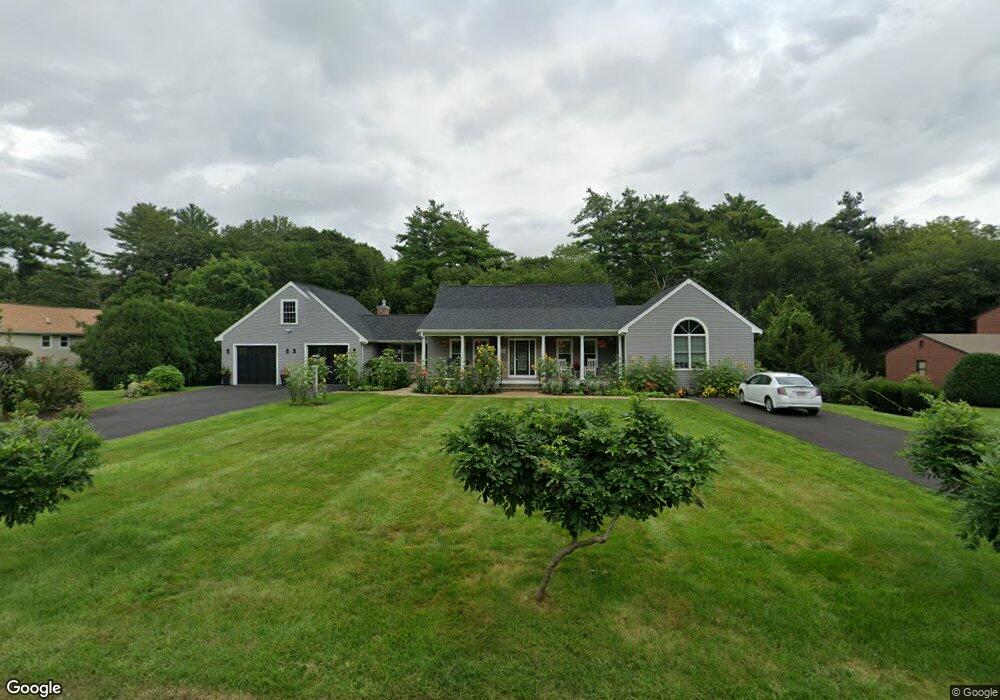
10 Brookside Ave Westport, MA 02790
North Westport NeighborhoodEstimated Value: $838,000 - $1,120,000
3
Beds
2
Baths
2,841
Sq Ft
$334/Sq Ft
Est. Value
About This Home
This home is located at 10 Brookside Ave, Westport, MA 02790 and is currently estimated at $948,282, approximately $333 per square foot. 10 Brookside Ave is a home located in Bristol County with nearby schools including Alice A. Macomber Primary School, Westport Elementary School, and Westport Middle-High School.
Ownership History
Date
Name
Owned For
Owner Type
Purchase Details
Closed on
Jul 22, 2013
Sold by
Aubin Thomas F
Bought by
Aubin Thomas F and Aubin Judith A
Current Estimated Value
Home Financials for this Owner
Home Financials are based on the most recent Mortgage that was taken out on this home.
Original Mortgage
$281,500
Outstanding Balance
$204,692
Interest Rate
3.92%
Mortgage Type
New Conventional
Estimated Equity
$743,590
Purchase Details
Closed on
Apr 24, 1998
Sold by
Germaine B Davis Nt and Citizens Union Sb
Bought by
Aubin Thomas F and Francoeur Judith A
Create a Home Valuation Report for This Property
The Home Valuation Report is an in-depth analysis detailing your home's value as well as a comparison with similar homes in the area
Home Values in the Area
Average Home Value in this Area
Purchase History
| Date | Buyer | Sale Price | Title Company |
|---|---|---|---|
| Aubin Thomas F | -- | -- | |
| Aubin Thomas F | $168,500 | -- |
Source: Public Records
Mortgage History
| Date | Status | Borrower | Loan Amount |
|---|---|---|---|
| Open | Aubin Thomas F | $281,500 | |
| Closed | Aubin Thomas F | $281,500 | |
| Previous Owner | Aubin Thomas F | $74,000 | |
| Previous Owner | Aubin Thomas F | $175,000 | |
| Previous Owner | Aubin Thomas F | $185,000 |
Source: Public Records
Tax History Compared to Growth
Tax History
| Year | Tax Paid | Tax Assessment Tax Assessment Total Assessment is a certain percentage of the fair market value that is determined by local assessors to be the total taxable value of land and additions on the property. | Land | Improvement |
|---|---|---|---|---|
| 2025 | $6,735 | $904,000 | $170,800 | $733,200 |
| 2024 | $6,064 | $784,500 | $158,300 | $626,200 |
| 2023 | $3,863 | $473,400 | $144,200 | $329,200 |
| 2022 | $3,497 | $412,400 | $131,100 | $281,300 |
| 2021 | $4,325 | $338,500 | $119,200 | $219,300 |
| 2020 | $4,126 | $333,700 | $114,400 | $219,300 |
| 2019 | $7,710 | $327,000 | $114,400 | $212,600 |
| 2018 | $7,390 | $306,300 | $114,300 | $192,000 |
| 2017 | $2,475 | $310,500 | $110,700 | $199,800 |
| 2016 | $2,360 | $298,400 | $107,000 | $191,400 |
| 2015 | $2,304 | $290,600 | $109,400 | $181,200 |
Source: Public Records
Map
Nearby Homes
- 27 Dias Ave
- 96 Forge Rd
- 16 S Berryman St
- 29 Union Ave
- 15 S Breault St
- 9 Kyle Jacob Rd
- 4 Main Rd
- 3 Roller Coaster Way Unit Lot 1
- 116 Gifford Rd
- 0 Van Buren St
- 565 Highland Ave
- 461 Reed Rd
- 56 Lakeside Ave
- 735 Reed Rd
- 20 Faulkner St
- 55 Lakeside Ave
- 771 Sanford Rd
- 818 Reed Rd
- 47 Fallon Dr
- Lot 0 Marcotte
- 14 Brookside Ave
- 6 Brookside Ave
- 5 Brookside Ave
- 2 Brookside Ave
- 15 Brookside Ave
- 19 Brookside Ave
- 20 Brookside Ave
- 71 Forsythia Ln
- 37 Mary Lou Ave
- 75 Forsythia Ln
- 23 Brookside Ave
- 81 Forsythia Ln
- 69 Forsythia Ln
- 31 Mary Lou Ave
- 40 Mary Lou Ave
- 24 Brookside Ave
- 18 Dias Ave
- 36 Mary Lou Ave
- 12 Dias Ave
- 32 Mary Lou Ave Unit WINTER RENT