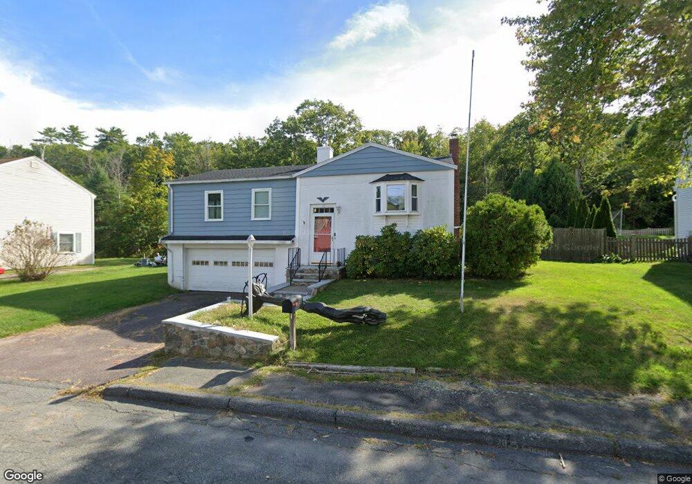
10 Cedarwood Rd Gloucester, MA 01930
West Gloucester NeighborhoodEstimated Value: $525,000 - $727,000
3
Beds
1
Bath
925
Sq Ft
$679/Sq Ft
Est. Value
About This Home
This home is located at 10 Cedarwood Rd, Gloucester, MA 01930 and is currently estimated at $627,704, approximately $678 per square foot. 10 Cedarwood Rd is a home located in Essex County with nearby schools including West Parish, Ralph B O'maley Middle School, and Gloucester High School.
Ownership History
Date
Name
Owned For
Owner Type
Purchase Details
Closed on
Jul 14, 2023
Sold by
Tarr Richard S
Bought by
Tarr Allison C and Tarr Meghan E
Current Estimated Value
Purchase Details
Closed on
Nov 9, 2018
Sold by
Tarr Eleanora T and Tarr Richard S
Bought by
Carney-Tarr Allison and Tarr Meghan E
Purchase Details
Closed on
Jul 1, 1977
Bought by
Tarr Richard S and Tarr Eleanora T
Create a Home Valuation Report for This Property
The Home Valuation Report is an in-depth analysis detailing your home's value as well as a comparison with similar homes in the area
Home Values in the Area
Average Home Value in this Area
Purchase History
| Date | Buyer | Sale Price | Title Company |
|---|---|---|---|
| Tarr Allison C | -- | None Available | |
| Carney-Tarr Allison | -- | -- | |
| Tarr Richard S | $44,800 | -- |
Source: Public Records
Mortgage History
| Date | Status | Borrower | Loan Amount |
|---|---|---|---|
| Previous Owner | Tarr Richard S | $135,000 | |
| Previous Owner | Tarr Richard S | $80,000 | |
| Previous Owner | Tarr Richard S | $25,000 | |
| Previous Owner | Tarr Richard S | $15,000 |
Source: Public Records
Tax History
| Year | Tax Paid | Tax Assessment Tax Assessment Total Assessment is a certain percentage of the fair market value that is determined by local assessors to be the total taxable value of land and additions on the property. | Land | Improvement |
|---|---|---|---|---|
| 2025 | $4,762 | $489,900 | $177,500 | $312,400 |
| 2024 | $5,007 | $514,600 | $169,100 | $345,500 |
| 2023 | $4,718 | $445,500 | $150,900 | $294,600 |
| 2022 | $4,400 | $375,100 | $131,300 | $243,800 |
| 2021 | $4,273 | $343,500 | $119,300 | $224,200 |
| 2020 | $4,001 | $324,500 | $119,300 | $205,200 |
| 2019 | $4,005 | $315,600 | $119,300 | $196,300 |
| 2018 | $3,764 | $291,100 | $119,300 | $171,800 |
| 2017 | $3,553 | $269,400 | $113,700 | $155,700 |
| 2016 | $3,518 | $258,500 | $118,600 | $139,900 |
| 2015 | $3,486 | $255,400 | $118,600 | $136,800 |
Source: Public Records
Map
Nearby Homes
- 7 Leaman Dr
- 167 Atlantic St
- 368 Essex Ave
- 178 Atlantic St
- 5 Samoset Rd Unit B
- 13 Honeysuckle Rd
- 226 Atlantic St
- 5 Lepage Ln
- 24 Cobblestone Ln Unit 603
- 587 Essex Ave
- 145 Essex Ave Unit 402
- 2 Breezy Point Rd
- 15 Lufkin Point Rd
- 3 Deacon Farm Ln
- 31 Echo Ave
- 3 Rockland St
- 6 Monroe Ct
- 15 Harvard St
- 672 Washington St
- 5 Marshfield St
Your Personal Tour Guide
Ask me questions while you tour the home.