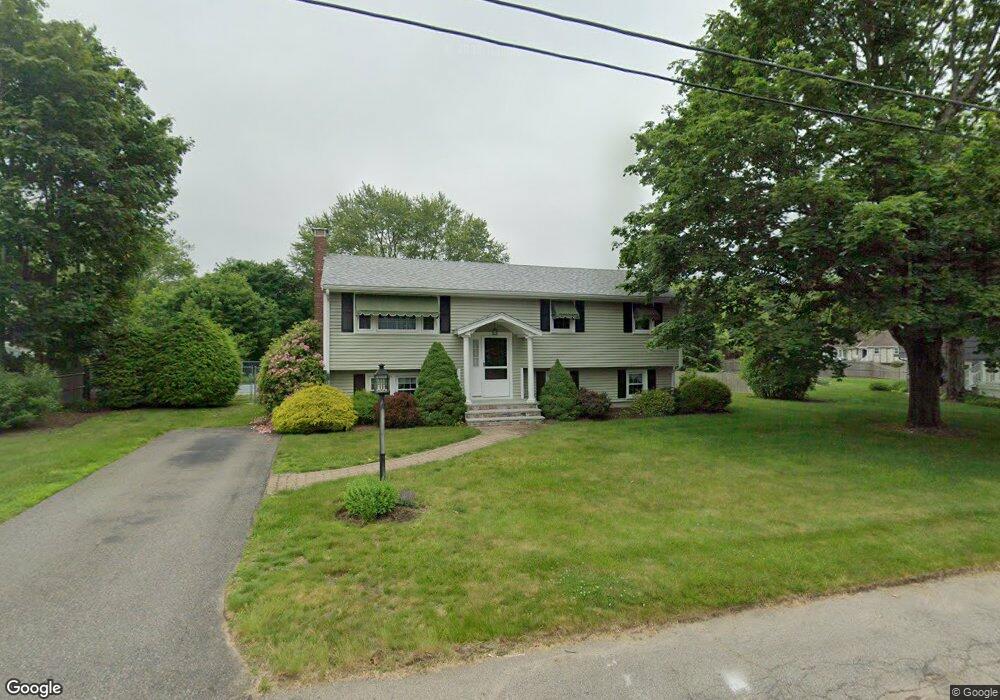
10 Chestnut Dr Brockton, MA 02301
Clifton Heights NeighborhoodEstimated Value: $561,000 - $622,000
3
Beds
2
Baths
1,792
Sq Ft
$332/Sq Ft
Est. Value
About This Home
This home is located at 10 Chestnut Dr, Brockton, MA 02301 and is currently estimated at $595,245, approximately $332 per square foot. 10 Chestnut Dr is a home located in Plymouth County with nearby schools including Gilmore Elementary School, John F. Kennedy Elementary School, and Davis K-8 School.
Ownership History
Date
Name
Owned For
Owner Type
Purchase Details
Closed on
Sep 24, 2008
Sold by
Macdonald Joseph J and Macdonald Priscilla R
Bought by
Macdonald Ft
Current Estimated Value
Home Financials for this Owner
Home Financials are based on the most recent Mortgage that was taken out on this home.
Original Mortgage
$50,000
Outstanding Balance
$33,526
Interest Rate
6.69%
Estimated Equity
$561,719
Create a Home Valuation Report for This Property
The Home Valuation Report is an in-depth analysis detailing your home's value as well as a comparison with similar homes in the area
Home Values in the Area
Average Home Value in this Area
Purchase History
| Date | Buyer | Sale Price | Title Company |
|---|---|---|---|
| Macdonald Ft | -- | -- |
Source: Public Records
Mortgage History
| Date | Status | Borrower | Loan Amount |
|---|---|---|---|
| Open | Macdonald Ft | $50,000 | |
| Previous Owner | Macdonald Ft | $25,000 |
Source: Public Records
Tax History Compared to Growth
Tax History
| Year | Tax Paid | Tax Assessment Tax Assessment Total Assessment is a certain percentage of the fair market value that is determined by local assessors to be the total taxable value of land and additions on the property. | Land | Improvement |
|---|---|---|---|---|
| 2025 | $6,466 | $533,900 | $140,500 | $393,400 |
| 2024 | $6,206 | $516,300 | $140,500 | $375,800 |
| 2023 | $5,854 | $451,000 | $106,200 | $344,800 |
| 2022 | $5,191 | $371,600 | $96,500 | $275,100 |
| 2021 | $4,772 | $329,100 | $80,600 | $248,500 |
| 2020 | $4,784 | $315,800 | $75,100 | $240,700 |
| 2019 | $4,387 | $282,300 | $73,100 | $209,200 |
| 2018 | $4,372 | $272,200 | $73,100 | $199,100 |
| 2017 | $4,096 | $254,400 | $73,100 | $181,300 |
| 2016 | $3,613 | $208,100 | $71,000 | $137,100 |
| 2015 | $3,768 | $207,600 | $71,000 | $136,600 |
| 2014 | $3,408 | $188,000 | $71,000 | $117,000 |
Source: Public Records
Map
Nearby Homes
- 422 W Chestnut St
- 20 Chestnut Dr
- 40 Chestnut Dr
- 418 W Chestnut St
- 11 Chestnut Dr
- 428 W Chestnut St
- 19 Chestnut Dr
- 412 W Chestnut St
- 423 W Chestnut St
- 50 Chestnut Dr
- 25 Chestnut Dr
- 25 Chestnut Dr Unit 2
- 25 Chestnut Dr Unit 3
- 430 W Chestnut St
- 39 Chestnut Dr
- 45 Chestnut Dr
- 396 W Chestnut St
- 443 W Chestnut St
- 27 Chestnut Dr
- 10 Alexandras Way