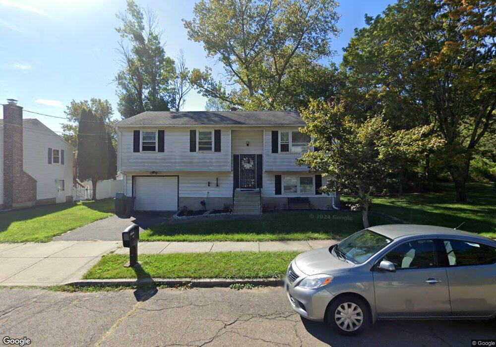
10 Chris Jon Cir West Haven, CT 06516
Allingtown NeighborhoodEstimated Value: $337,000 - $388,000
3
Beds
2
Baths
1,080
Sq Ft
$329/Sq Ft
Est. Value
About This Home
This home is located at 10 Chris Jon Cir, West Haven, CT 06516 and is currently estimated at $355,724, approximately $329 per square foot. 10 Chris Jon Cir is a home located in New Haven County with nearby schools including Carrigan 5/6 Intermediate School, Harry M. Bailey Middle School, and West Haven High School.
Ownership History
Date
Name
Owned For
Owner Type
Purchase Details
Closed on
Mar 19, 2023
Sold by
Levey Thalia
Bought by
Levey Thahilia T and Heron Mustapha
Current Estimated Value
Purchase Details
Closed on
Oct 2, 1996
Sold by
Robinson Thomas M and Robinson Earlina C
Bought by
Heron Thalia T
Create a Home Valuation Report for This Property
The Home Valuation Report is an in-depth analysis detailing your home's value as well as a comparison with similar homes in the area
Home Values in the Area
Average Home Value in this Area
Purchase History
| Date | Buyer | Sale Price | Title Company |
|---|---|---|---|
| Levey Thahilia T | -- | None Available | |
| Levey Thahilia T | -- | None Available | |
| Heron Thalia T | $100,000 | -- | |
| Heron Thalia T | $100,000 | -- |
Source: Public Records
Mortgage History
| Date | Status | Borrower | Loan Amount |
|---|---|---|---|
| Previous Owner | Heron Thalia T | $183,900 | |
| Previous Owner | Heron Thalia T | $170,000 | |
| Previous Owner | Heron Thalia T | $94,500 | |
| Previous Owner | Heron Thalia T | $75,000 |
Source: Public Records
Tax History Compared to Growth
Tax History
| Year | Tax Paid | Tax Assessment Tax Assessment Total Assessment is a certain percentage of the fair market value that is determined by local assessors to be the total taxable value of land and additions on the property. | Land | Improvement |
|---|---|---|---|---|
| 2025 | $6,899 | $202,860 | $71,540 | $131,320 |
| 2024 | $6,410 | $133,840 | $49,560 | $84,280 |
| 2023 | $6,213 | $133,840 | $49,560 | $84,280 |
| 2022 | $6,104 | $133,840 | $49,560 | $84,280 |
| 2021 | $6,106 | $133,840 | $49,560 | $84,280 |
| 2020 | $6,276 | $121,870 | $45,290 | $76,580 |
| 2019 | $6,179 | $121,870 | $45,290 | $76,580 |
| 2018 | $6,011 | $121,870 | $45,290 | $76,580 |
| 2017 | $5,823 | $121,870 | $45,290 | $76,580 |
| 2016 | $5,646 | $121,870 | $45,290 | $76,580 |
| 2015 | $5,472 | $134,470 | $50,050 | $84,420 |
| 2014 | $5,363 | $134,470 | $50,050 | $84,420 |
Source: Public Records
Map
Nearby Homes
- 50 Morris Ave
- 0 Burwell Rd
- 0 Burwell & Woodfield Rd Unit 24051262
- 36 Forest Hills Rd
- 56 Highview Ave
- 52 Highview Ave
- 29 Birch St
- 100 Yates St
- 11 Priscilla Rd
- 65 Westfield St
- 38 Chauncey St
- 60 Andrews St
- 699 Forest Rd
- 690 Forest Rd Unit 702
- 690 Forest Rd Unit 392
- 690 Forest Rd Unit 511
- 22 Bristol St
- 103 Gilbert St
- 78 Nonquit St
- 14 Homestead Ave