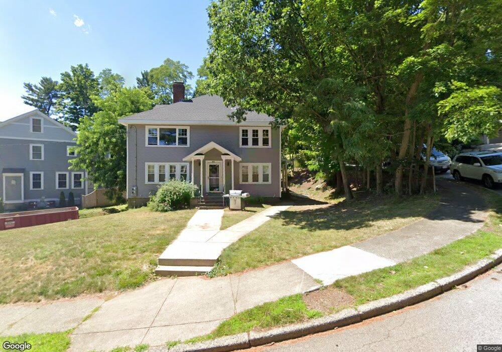
10 Craigie Terrace Unit 12 Newtonville, MA 02460
Newtonville NeighborhoodEstimated Value: $1,595,000 - $1,791,060
5
Beds
3
Baths
3,591
Sq Ft
$476/Sq Ft
Est. Value
About This Home
This home is located at 10 Craigie Terrace Unit 12, Newtonville, MA 02460 and is currently estimated at $1,710,015, approximately $476 per square foot. 10 Craigie Terrace Unit 12 is a home located in Middlesex County with nearby schools including Cabot Elementary School, F.A. Day Middle School, and Newton North High School.
Ownership History
Date
Name
Owned For
Owner Type
Purchase Details
Closed on
May 15, 2023
Sold by
Konstantopoulos Maria and Konstantopoulos Efthimios
Bought by
Konstantopoulos Maria and Tafa Erand
Current Estimated Value
Purchase Details
Closed on
Oct 30, 2020
Sold by
E & D Rt
Bought by
Konstantopoulos Maria and Konstantopoulos Efthimios
Purchase Details
Closed on
Sep 1, 2006
Sold by
Horlink Doris B and Horlink Edward
Bought by
E&D Rt and Horlink Doris B
Create a Home Valuation Report for This Property
The Home Valuation Report is an in-depth analysis detailing your home's value as well as a comparison with similar homes in the area
Home Values in the Area
Average Home Value in this Area
Purchase History
| Date | Buyer | Sale Price | Title Company |
|---|---|---|---|
| Konstantopoulos Maria | -- | None Available | |
| Konstantopoulos Maria | $1,100,000 | None Available | |
| E&D Rt | -- | -- |
Source: Public Records
Tax History Compared to Growth
Tax History
| Year | Tax Paid | Tax Assessment Tax Assessment Total Assessment is a certain percentage of the fair market value that is determined by local assessors to be the total taxable value of land and additions on the property. | Land | Improvement |
|---|---|---|---|---|
| 2025 | $14,996 | $1,530,200 | $1,059,100 | $471,100 |
| 2024 | $14,499 | $1,485,600 | $1,028,300 | $457,300 |
| 2023 | $13,363 | $1,312,700 | $827,700 | $485,000 |
| 2022 | $10,783 | $1,025,000 | $766,400 | $258,600 |
| 2021 | $10,119 | $940,400 | $703,100 | $237,300 |
| 2020 | $9,818 | $940,400 | $703,100 | $237,300 |
| 2019 | $9,185 | $878,900 | $657,100 | $221,800 |
| 2018 | $9,179 | $848,300 | $618,100 | $230,200 |
| 2017 | $8,655 | $778,300 | $567,100 | $211,200 |
| 2016 | $8,125 | $714,000 | $520,300 | $193,700 |
| 2015 | $7,747 | $667,300 | $486,300 | $181,000 |
Source: Public Records
Map
Nearby Homes
- 61 Lakeview Ave
- 308 Prince St
- 22 Walnut Place Unit 1
- 123-125 Mount Vernon St
- 123 Mount Vernon St Unit 2
- 39 Valentine Park
- 34 Morton Rd
- 887 Commonwealth Ave
- 957 Washington St Unit 1
- 935 Washington St Unit 8
- 300 Cabot St
- 318 Austin St Unit A
- 911 Washington St
- 12 Wiswall St
- 4 Wiswall St
- 3 Cedar St
- 127-129 Withington Rd Unit 1
- 27 Cross St Unit 27
- 10 Washington Park
- 10 Washington Park Unit 2
- 10 Craigie Terrace Unit 1
- 12 Craigie Terrace Unit 2
- 439 Lowell Ave Unit 441
- 441 Lowell Ave Unit 441
- 427 Lowell Ave
- 9-11 Craigie Terrace
- 9 Craigie Terrace Unit 11
- 5 Craigie Terrace
- 425 Lowell Ave
- 423 Lowell Ave
- 423 Lowell Ave Unit 425
- 423 Lowell Ave Unit 423
- 425 Lowell Ave Unit 2nd Floor
- 425 Lowell Ave Unit 425
- 444 Lowell Ave
- 444 Lowell Ave Unit 2
- 444 Lowell Ave
- 440 Lowell Ave
- 440 Lowell Ave Unit 440
- 440 Lowell Ave Unit A