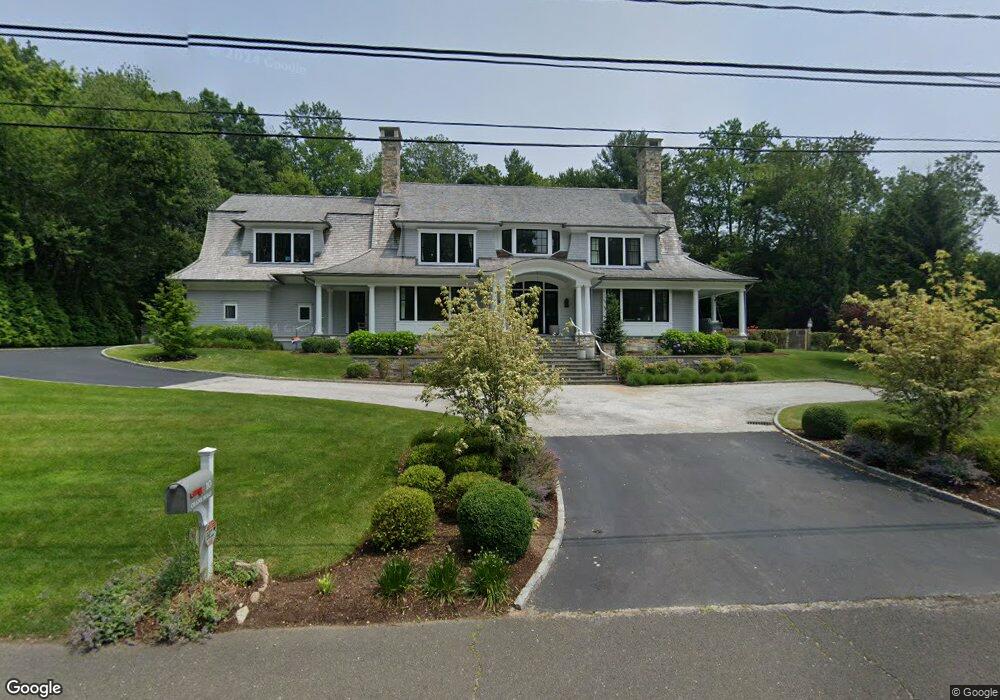
10 Crane Rd Darien, CT 06820
Estimated Value: $5,576,000 - $8,128,294
5
Beds
6
Baths
6,160
Sq Ft
$1,065/Sq Ft
Est. Value
About This Home
This home is located at 10 Crane Rd, Darien, CT 06820 and is currently estimated at $6,557,765, approximately $1,064 per square foot. 10 Crane Rd is a home located in Fairfield County with nearby schools including Tokeneke Elementary School, Middlesex Middle School, and Darien High School.
Ownership History
Date
Name
Owned For
Owner Type
Purchase Details
Closed on
Nov 2, 2015
Sold by
Criscuolo Aldo and Criscuolo Ellen
Bought by
Urban Jeffrey and Urban Diane
Current Estimated Value
Home Financials for this Owner
Home Financials are based on the most recent Mortgage that was taken out on this home.
Original Mortgage
$1,000,000
Outstanding Balance
$746,907
Interest Rate
2.38%
Mortgage Type
Adjustable Rate Mortgage/ARM
Estimated Equity
$5,810,858
Purchase Details
Closed on
Aug 25, 2000
Sold by
Schofield John and Schofield Ann P
Bought by
Criscuolo Aldo and Criscuolo Ellen
Create a Home Valuation Report for This Property
The Home Valuation Report is an in-depth analysis detailing your home's value as well as a comparison with similar homes in the area
Home Values in the Area
Average Home Value in this Area
Purchase History
| Date | Buyer | Sale Price | Title Company |
|---|---|---|---|
| Urban Jeffrey | $2,510,000 | -- | |
| Criscuolo Aldo | $1,165,000 | -- |
Source: Public Records
Mortgage History
| Date | Status | Borrower | Loan Amount |
|---|---|---|---|
| Open | Criscuolo Aldo | $1,000,000 | |
| Previous Owner | Criscuolo Aldo | $496,000 | |
| Previous Owner | Criscuolo Aldo | $708,750 | |
| Previous Owner | Criscuolo Aldo | $500,000 |
Source: Public Records
Tax History
| Year | Tax Paid | Tax Assessment Tax Assessment Total Assessment is a certain percentage of the fair market value that is determined by local assessors to be the total taxable value of land and additions on the property. | Land | Improvement |
|---|---|---|---|---|
| 2025 | $51,597 | $3,333,120 | $1,626,870 | $1,706,250 |
| 2024 | $48,964 | $3,333,120 | $1,626,870 | $1,706,250 |
| 2023 | $49,308 | $2,800,000 | $1,162,070 | $1,637,930 |
| 2022 | $48,244 | $2,800,000 | $1,162,070 | $1,637,930 |
| 2021 | $0 | $2,800,000 | $1,162,070 | $1,637,930 |
| 2020 | $49,395 | $3,019,240 | $1,162,070 | $1,857,170 |
| 2019 | $155 | $3,019,240 | $1,162,070 | $1,857,170 |
| 2018 | $44,152 | $2,745,750 | $959,140 | $1,786,610 |
| 2017 | $0 | $1,553,440 | $959,140 | $594,300 |
| 2016 | $19,532 | $1,238,580 | $959,140 | $279,440 |
| 2015 | $19,012 | $1,238,580 | $959,140 | $279,440 |
| 2014 | $18,591 | $1,238,580 | $959,140 | $279,440 |
Source: Public Records
Map
Nearby Homes
- 18 Pasture Ln
- 23 Beach Dr
- 20 Outlook Dr
- 3 Salt Box Ln E
- 7 Dora St Unit 7
- 33 Dora St
- 32 Relihan Rd
- 950 Cove Rd Unit B6
- 86 Wallacks Dr
- 85 Avery St
- 66 Stanton Rd
- 17 Contentment Island Rd
- 104 Sylvan Knoll Rd
- 12 Walmsley Rd
- 74 Palmer Ave
- 18 Tokeneke Trail
- 77 Maple St
- 163 Sylvan Knoll Rd
- 171 Sylvan Knoll Rd
- 697 Cove Rd Unit 1B
- 14 Crane Rd
- 6 Crane Rd
- 108 Long Neck Point Rd
- 120 Long Neck Point Rd
- 9 Crane Rd
- 5 Crane Rd
- 106 Long Neck Point Rd
- 15 Crane Rd
- 18 Crane Rd
- 4 Crane Rd
- 96 Long Neck Point Rd
- 100 Long Neck Point Rd
- 130 Long Neck Point Rd
- 112 Pear Tree Point Rd
- 116 Pear Tree Point Rd
- 102 Long Neck Point Rd
- 124 Pear Tree Point Rd
- 17 Crane Rd
- 78 Long Neck Point Rd
- 115 Long Neck Point Rd
Your Personal Tour Guide
Ask me questions while you tour the home.