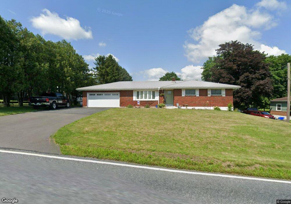
10 Dad Burnhams Rd Pine Grove, PA 17963
Estimated Value: $297,000 - $395,000
3
Beds
2
Baths
1,684
Sq Ft
$195/Sq Ft
Est. Value
About This Home
This home is located at 10 Dad Burnhams Rd, Pine Grove, PA 17963 and is currently estimated at $328,472, approximately $195 per square foot. 10 Dad Burnhams Rd is a home located in Schuylkill County with nearby schools including Pine Grove Elementary School, Pine Grove Area Middle School, and Pine Grove Area High School.
Ownership History
Date
Name
Owned For
Owner Type
Purchase Details
Closed on
Jun 4, 2018
Sold by
Butz Audrey L
Bought by
Staller Robert C and Staller Ellen L
Current Estimated Value
Purchase Details
Closed on
Jun 13, 2008
Sold by
Harris Irma M
Bought by
Butz Audrey L
Home Financials for this Owner
Home Financials are based on the most recent Mortgage that was taken out on this home.
Original Mortgage
$170,590
Outstanding Balance
$109,746
Interest Rate
6.1%
Mortgage Type
VA
Estimated Equity
$218,726
Create a Home Valuation Report for This Property
The Home Valuation Report is an in-depth analysis detailing your home's value as well as a comparison with similar homes in the area
Home Values in the Area
Average Home Value in this Area
Purchase History
| Date | Buyer | Sale Price | Title Company |
|---|---|---|---|
| Staller Robert C | -- | None Available | |
| Butz Audrey L | $167,000 | None Available |
Source: Public Records
Mortgage History
| Date | Status | Borrower | Loan Amount |
|---|---|---|---|
| Open | Butz Audrey L | $170,590 |
Source: Public Records
Tax History Compared to Growth
Tax History
| Year | Tax Paid | Tax Assessment Tax Assessment Total Assessment is a certain percentage of the fair market value that is determined by local assessors to be the total taxable value of land and additions on the property. | Land | Improvement |
|---|---|---|---|---|
| 2025 | $3,966 | $59,300 | $12,500 | $46,800 |
| 2024 | $3,595 | $59,300 | $12,500 | $46,800 |
| 2023 | $3,595 | $59,300 | $12,500 | $46,800 |
| 2022 | $3,595 | $59,300 | $12,500 | $46,800 |
| 2021 | $3,631 | $59,300 | $12,500 | $46,800 |
| 2020 | $3,631 | $59,300 | $12,500 | $46,800 |
| 2018 | $3,512 | $59,300 | $12,500 | $46,800 |
| 2017 | $3,403 | $59,300 | $12,500 | $46,800 |
| 2015 | -- | $59,300 | $12,500 | $46,800 |
| 2011 | -- | $59,300 | $0 | $0 |
Source: Public Records
Map
Nearby Homes
- 979 Deturksville Rd
- 1114 Deturksville Rd
- 234 Frieden Manor
- 651 Deturksville Rd
- 519 Birds Hill Rd
- 248 Browns Rd
- 118 Natures Rd
- 0 Beech Tree Dr
- 107 Blue Mountain Rd
- 9 Hallton Hill Rd
- 149 Pleasant Valley Rd
- 0 Camp Rd
- 0 Manor Rd
- 145 Sweet Arrow Lake Rd
- 0 Pine Hill Dr Unit PASK2023770
- 30 Meadow Brook Dr
- 59 E Pottsville St
- 57 E Pottsville St
- 204 Stanhope Rd
- 8 Carbon St
- 10 Dad Burnhams Rd
- 14 Dad Burnhams Rd
- 8 Dad Burnhams Rd
- 20 Dad Burnhams Rd
- 6 Dad Burnhams Rd
- 11 Dad Burnhams Rd
- 980 Deturksville Rd
- 970 Deturksville Rd
- 31 Dad Burnhams Rd
- 0 Rt 443 Unit 1005001712
- 0 Rt 443 Unit 1005004248
- 0 Rt 443 Unit 6707247
- 0 Rt 443 Unit 6707248
- 977 Deturksville Rd
- 946 Deturksville Rd
- 1020 Deturksville Rd
- 922 Deturksville Rd
- 945 Deturksville Rd
- 40 Harvey Dr
- 2 Harvey Dr