Estimated Value: $900,228 - $1,178,000
Studio
--
Bath
3,661
Sq Ft
$274/Sq Ft
Est. Value
About This Home
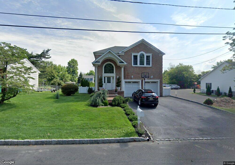
This home is located at 10 Denman Ave, Clark, NJ 07066 and is currently estimated at $1,002,057, approximately $273 per square foot. 10 Denman Ave is a home located in Union County with nearby schools including Valley Road Elementary School, Carl H. Kumpf Middle School, and Arthur L. Johnson High School.
Ownership History
Date
Name
Owned For
Owner Type
Purchase Details
Closed on
Oct 5, 2006
Sold by
Samsel John
Bought by
Costa Beata
Current Estimated Value
Purchase Details
Closed on
Jul 6, 2006
Sold by
Sottos William C
Bought by
4 Wise Men Llc
Create a Home Valuation Report for This Property
The Home Valuation Report is an in-depth analysis detailing your home's value as well as a comparison with similar homes in the area
Home Values in the Area
Average Home Value in this Area
Purchase History
| Date | Buyer | Sale Price | Title Company |
|---|---|---|---|
| Costa Beata | $270,000 | -- | |
| 4 Wise Men Llc | $197,000 | -- |
Source: Public Records
Tax History
| Year | Tax Paid | Tax Assessment Tax Assessment Total Assessment is a certain percentage of the fair market value that is determined by local assessors to be the total taxable value of land and additions on the property. | Land | Improvement |
|---|---|---|---|---|
| 2025 | $15,144 | $684,000 | $262,300 | $421,700 |
| 2024 | $14,918 | $684,000 | $262,300 | $421,700 |
| 2023 | $14,918 | $684,000 | $262,300 | $421,700 |
| 2022 | $14,487 | $684,000 | $262,300 | $421,700 |
| 2021 | $14,366 | $161,600 | $42,000 | $119,600 |
| 2020 | $14,132 | $161,600 | $42,000 | $119,600 |
| 2019 | $13,990 | $161,600 | $42,000 | $119,600 |
| 2018 | $13,822 | $161,600 | $42,000 | $119,600 |
| 2017 | $13,600 | $161,600 | $42,000 | $119,600 |
| 2016 | $13,099 | $161,600 | $42,000 | $119,600 |
| 2015 | $12,967 | $161,600 | $42,000 | $119,600 |
| 2014 | $12,694 | $161,600 | $42,000 | $119,600 |
Source: Public Records
Map
Nearby Homes
- 45 Lexington Blvd
- 272 Westfield Ave
- 30 Brant Ave
- 157 Westfield Ave
- 122 Central Ave
- 85 Fulton St
- 44 Joseph St
- 52 Broadway
- 81 Hutchinson St
- 22 Washington St
- 33 Cornell Dr
- 66 Lincoln Blvd
- 1044 Madison Hill Rd
- 262 Valley Rd
- 275 Valley Rd
- 1206 Westfield Ave
- 205 West Ln
- 302 New York Ave
- 17 Rolling Hill Way
- 814 Falesky St
- 22 Denman Ave
- 254 Westfield Ave
- 28 Denman Ave
- 27 Lexington Blvd
- 25 Lexington Blvd
- 33 Lexington Blvd
- 246 Westfield Ave
- 19 Lexington Blvd
- 35 Lexington Blvd
- 23 Denman Ave
- 15 Lexington Blvd
- 39 Lexington Blvd
- 260 Westfield Ave
- 34 Denman Ave
- 35 Denman Ave
- 266 Westfield Ave
- 49 Lexington Blvd
- 265 Westfield Ave
- 261 Westfield Ave
- 40 Denman Ave
Your Personal Tour Guide
Ask me questions while you tour the home.