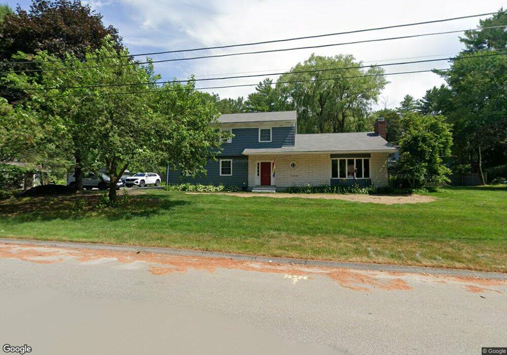
10 Eaton Dr Waterville, ME 04901
Estimated Value: $398,000 - $466,000
4
Beds
3
Baths
3,060
Sq Ft
$146/Sq Ft
Est. Value
About This Home
This home is located at 10 Eaton Dr, Waterville, ME 04901 and is currently estimated at $445,492, approximately $145 per square foot. 10 Eaton Dr is a home located in Kennebec County with nearby schools including George J. Mitchell School, Albert S. Hall School, and Waterville Junior High School.
Ownership History
Date
Name
Owned For
Owner Type
Purchase Details
Closed on
May 4, 2009
Sold by
Noland James P and Noland Sarah A
Bought by
Jackson David W and Jackson Susan E
Current Estimated Value
Home Financials for this Owner
Home Financials are based on the most recent Mortgage that was taken out on this home.
Original Mortgage
$70,000
Outstanding Balance
$43,869
Interest Rate
4.86%
Mortgage Type
Purchase Money Mortgage
Estimated Equity
$401,623
Purchase Details
Closed on
Aug 25, 2008
Sold by
Freeman Mark A and Freeman Ruvani S
Bought by
Noland James P and Noland Sarah A
Create a Home Valuation Report for This Property
The Home Valuation Report is an in-depth analysis detailing your home's value as well as a comparison with similar homes in the area
Home Values in the Area
Average Home Value in this Area
Purchase History
| Date | Buyer | Sale Price | Title Company |
|---|---|---|---|
| Jackson David W | -- | -- | |
| Noland James P | $202,000 | -- |
Source: Public Records
Mortgage History
| Date | Status | Borrower | Loan Amount |
|---|---|---|---|
| Open | Jackson David W | $70,000 |
Source: Public Records
Tax History Compared to Growth
Tax History
| Year | Tax Paid | Tax Assessment Tax Assessment Total Assessment is a certain percentage of the fair market value that is determined by local assessors to be the total taxable value of land and additions on the property. | Land | Improvement |
|---|---|---|---|---|
| 2025 | $8,036 | $472,700 | $58,400 | $414,300 |
| 2024 | $8,042 | $402,100 | $44,800 | $357,300 |
| 2023 | $8,002 | $402,100 | $44,800 | $357,300 |
| 2022 | $6,636 | $256,700 | $33,900 | $222,800 |
| 2021 | $6,546 | $256,700 | $33,900 | $222,800 |
| 2020 | $6,613 | $256,700 | $33,900 | $222,800 |
| 2019 | $3,405 | $256,700 | $33,900 | $222,800 |
| 2018 | $6,487 | $256,700 | $33,900 | $222,800 |
| 2017 | $5,989 | $256,700 | $33,900 | $222,800 |
| 2016 | $3,102 | $256,700 | $33,900 | $222,800 |
| 2015 | $5,121 | $184,200 | $34,900 | $149,300 |
| 2014 | $5,047 | $184,200 | $34,900 | $149,300 |
| 2013 | $5,047 | $184,200 | $34,900 | $149,300 |
Source: Public Records
Map
Nearby Homes
- 28 1st Rangeway
- 81 1st Rangeway
- 8 Forest Park
- 13 Lincoln Woods Ln
- 19 Sterling St
- 114 Carver St
- 21 Morgan St
- 1 Bowie Ln
- 111 Evergreen Dr
- 31 Merryfield Ave
- 104 Evergreen Dr Unit 104
- 71 Oakland St
- 28 Mathews Ave
- 11 Russell St
- 5 Collette St
- 144-146 1st Rangeway
- 122 Western Ave
- 851 Lincoln St
- 35 Oakland St
- 10 Edgewood St