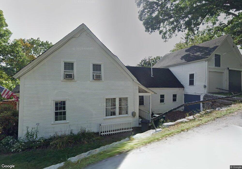
10 Edwards St Wilton, NH 03086
Estimated Value: $359,000 - $484,000
2
Beds
2
Baths
1,954
Sq Ft
$202/Sq Ft
Est. Value
About This Home
This home is located at 10 Edwards St, Wilton, NH 03086 and is currently estimated at $395,487, approximately $202 per square foot. 10 Edwards St is a home located in Hillsborough County with nearby schools including Florence Rideout Elementary School, Wilton-Lyndeborough Cooperative Middle School, and Wilton-Lyndeborough Cooperative High School.
Ownership History
Date
Name
Owned For
Owner Type
Purchase Details
Closed on
Jan 30, 2018
Sold by
Gardent Cynthia M
Bought by
Gardent Andrew B
Current Estimated Value
Purchase Details
Closed on
Dec 31, 2012
Sold by
Gardent Andrew B
Bought by
Gardent Andrew B and Gardent Cynthia M
Home Financials for this Owner
Home Financials are based on the most recent Mortgage that was taken out on this home.
Original Mortgage
$144,000
Interest Rate
3.38%
Mortgage Type
Purchase Money Mortgage
Purchase Details
Closed on
Nov 20, 2002
Sold by
Boska Susan L
Bought by
Gardent Andrew B
Home Financials for this Owner
Home Financials are based on the most recent Mortgage that was taken out on this home.
Original Mortgage
$87,000
Interest Rate
6.07%
Create a Home Valuation Report for This Property
The Home Valuation Report is an in-depth analysis detailing your home's value as well as a comparison with similar homes in the area
Home Values in the Area
Average Home Value in this Area
Purchase History
| Date | Buyer | Sale Price | Title Company |
|---|---|---|---|
| Gardent Andrew B | -- | -- | |
| Gardent Andrew B | -- | -- | |
| Gardent Andrew B | $145,000 | -- |
Source: Public Records
Mortgage History
| Date | Status | Borrower | Loan Amount |
|---|---|---|---|
| Previous Owner | Gardent Andrew B | $144,000 | |
| Previous Owner | Gardent Andrew B | $45,000 | |
| Previous Owner | Gardent Andrew B | $87,000 |
Source: Public Records
Tax History
| Year | Tax Paid | Tax Assessment Tax Assessment Total Assessment is a certain percentage of the fair market value that is determined by local assessors to be the total taxable value of land and additions on the property. | Land | Improvement |
|---|---|---|---|---|
| 2025 | $7,017 | $260,100 | $86,500 | $173,600 |
| 2024 | $6,469 | $260,100 | $86,500 | $173,600 |
| 2023 | $5,774 | $260,100 | $86,500 | $173,600 |
| 2022 | $5,374 | $260,100 | $86,500 | $173,600 |
| 2021 | $4,999 | $260,100 | $86,500 | $173,600 |
| 2020 | $5,070 | $172,500 | $64,000 | $108,500 |
| 2019 | $5,009 | $172,500 | $64,000 | $108,500 |
| 2018 | $4,961 | $172,500 | $64,000 | $108,500 |
| 2017 | $4,687 | $172,500 | $64,000 | $108,500 |
| 2016 | $4,544 | $172,500 | $64,000 | $108,500 |
| 2015 | $4,588 | $174,200 | $64,500 | $109,700 |
| 2014 | $4,494 | $174,200 | $64,500 | $109,700 |
| 2013 | $4,533 | $174,200 | $64,500 | $109,700 |
Source: Public Records
Map
Nearby Homes
- 54 Forest Rd
- 25 Burns Hill Rd
- 10 Whiting Hill Rd
- 123 Falcon Ridge Rd
- Lot 053 Holt Rd
- 82 Wilton Rd Unit A
- 82 Wilton Rd Unit B
- 82 Wilton Rd Unit A & B
- 33 Falcon Ridge Rd Unit 33
- 69 Falcon Ridge Rd
- 23 Falcon Ridge Rd Unit 23
- 24 Falcon Ridge Rd Unit 24
- 18 Richfield Way
- F-88-11 Aria Hill Dr
- F-88-12 Aria Hill Dr
- F-88-7 Aria Hill Dr
- F88-9 McGettigan Rd
- F/88-5 McGettigan Rd
- F/88-4 McGettigan Rd
- 16 Cortland Rd
Your Personal Tour Guide
Ask me questions while you tour the home.