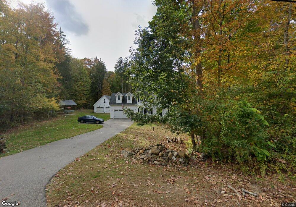
10 Flat Brook Rd East Hampton, CT 06424
Estimated Value: $511,000 - $608,000
4
Beds
7
Baths
2,132
Sq Ft
$271/Sq Ft
Est. Value
About This Home
This home is located at 10 Flat Brook Rd, East Hampton, CT 06424 and is currently estimated at $577,639, approximately $270 per square foot. 10 Flat Brook Rd is a home located in Middlesex County with nearby schools including Memorial School, Center Elementary School, and East Hampton Middle School.
Ownership History
Date
Name
Owned For
Owner Type
Purchase Details
Closed on
Apr 15, 2013
Sold by
Helming Karl R
Bought by
May Bruce D and May Dawn A
Current Estimated Value
Purchase Details
Closed on
Apr 29, 2011
Sold by
Pelletier Dev Co Llc
Bought by
Siezczkowski Mark and Siezczkowski Erin
Home Financials for this Owner
Home Financials are based on the most recent Mortgage that was taken out on this home.
Original Mortgage
$254,320
Interest Rate
4.76%
Create a Home Valuation Report for This Property
The Home Valuation Report is an in-depth analysis detailing your home's value as well as a comparison with similar homes in the area
Home Values in the Area
Average Home Value in this Area
Purchase History
| Date | Buyer | Sale Price | Title Company |
|---|---|---|---|
| May Bruce D | $50,000 | -- | |
| May Bruce D | $50,000 | -- | |
| Siezczkowski Mark | $317,900 | -- | |
| Siezczkowski Mark | $317,900 | -- |
Source: Public Records
Mortgage History
| Date | Status | Borrower | Loan Amount |
|---|---|---|---|
| Previous Owner | Siezczkowski Mark | $254,320 |
Source: Public Records
Tax History
| Year | Tax Paid | Tax Assessment Tax Assessment Total Assessment is a certain percentage of the fair market value that is determined by local assessors to be the total taxable value of land and additions on the property. | Land | Improvement |
|---|---|---|---|---|
| 2025 | $10,460 | $263,420 | $76,110 | $187,310 |
| 2024 | $10,020 | $263,420 | $76,120 | $187,300 |
| 2023 | $9,499 | $263,420 | $76,120 | $187,300 |
| 2022 | $9,130 | $263,420 | $76,120 | $187,300 |
| 2021 | $9,096 | $263,420 | $76,120 | $187,300 |
| 2020 | $6,615 | $199,610 | $11,250 | $188,360 |
| 2019 | $6,354 | $191,730 | $11,460 | $180,270 |
| 2018 | $6,005 | $191,730 | $11,460 | $180,270 |
| 2017 | $5,674 | $181,150 | $11,460 | $169,690 |
| 2016 | $5,333 | $181,150 | $11,460 | $169,690 |
| 2015 | $6,398 | $230,300 | $62,430 | $167,870 |
| 2014 | $5,566 | $230,300 | $62,430 | $167,870 |
Source: Public Records
Map
Nearby Homes
- 91-A Flatbrook Rd Unit 91
- 27 Edgerton St
- 119 Colchester Ave
- 130 Bear Swamp Rd
- 29 Watrous St
- 1 Watrous St
- 4 Watrous St
- 0002-5 Edgewater Cir
- 0002-7 Edgewater Cir
- 0002-6 Edgewater Cir
- 00023 Edgewater Cir
- 00026 Edgewater Cir
- 00025 Edgewater Cir
- 0002-3 Edgewater Cir
- 43 E High St
- 1 Steepleview Dr
- 3 Young St
- 14 Main St
- 141 E High St
- 24 N Main St
- 10 Flatbrook Rd
- Lot 10 Flatbrook
- 3 Olde Flatbrook Rd
- 6 Flat Brook Rd
- 9 Flatbrook Rd
- 9 Flatbrook Rd
- 9 Flatbrook Rd
- 9 Flatbrook Rd
- 1 Olde Flatbrook Rd
- 5 Olde Flatbrook Rd
- 131 Colchester Ave
- 9 Flatbrook Rd
- 130 Colchester Avenue(rt 16)
- 124 Colchester Ave
- 117 Colchester Ave Lots 4 & 5
- 117 Colchester Ave Lots 4 5 & 6
- 130 Colchester Ave
- 4 Olde Flatbrook Rd
- 3/89/34 Colchester Ave
- Lot 3 Colchester Ave
Your Personal Tour Guide
Ask me questions while you tour the home.